
Field Trips
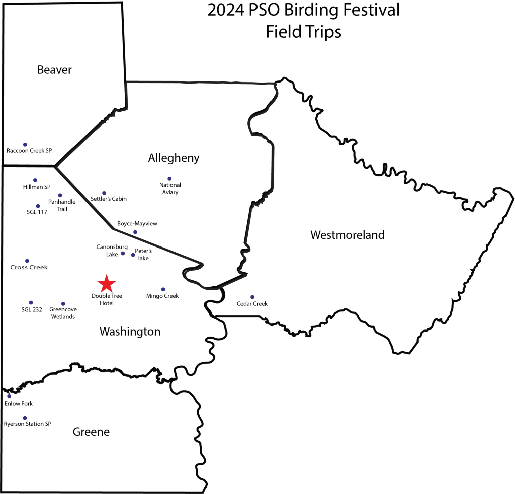
Friday, May 31, 2024
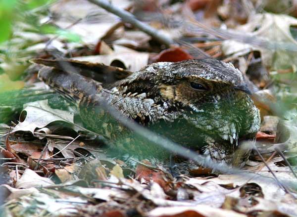
Hillman State Park – Night Birds
Led by Ryan Tomazin
Friday evening for Whip-poor-wills, Woodcocks, Moths, etc.
Meet at Hillman at these coordinates, 40.454685, -80.417683, the Five Points Extension Parking Lot.
TIME: 8:30 pm
NOTE: Limit of 10 for the Friday evening Field Trip
This is an undeveloped state park that is also a State Game Lands. The area features a variety of habitats including marshes, large ponds, pine plantations, grassland, shrub land and woods. Birding is mainly done along the gravel roads through the area. There are numerous areas to explore. Grassland access is on dirt paths. Note the area has numerous ticks, so staying on the road and trails is recommended. The trail through the grassland can be muddy if we have rain.
The evening outing on Friday will focus on listening for Eastern Whip-poor-wills and American Woodcocks that are fairly easy to find. Barred Owls and Great Horned Owls may also be heard. For those interested in moths, a lighted sheet to attract them will also be set up. You will be surprised at the variety of amazing and beautiful moths to be found.
Saturday, June 1, 2024

BOYCE-MAYVIEW PARK and WINGFIELD PINES
Led by Shannon Thompson
Saturday – Meet at the hotel at 6:30 AM.
Boyce-Mayview Park is on a former hospital property in southern Allegheny County that is now a public park in Upper St. Clair. Habitats include several ponds and wetlands, open fields and forest. Spring offers a great display of wildflowers and migrating warblers. Some rare herons have occurred at this park including Little Blue Heron and Black-crowned Night-Heron (rare in southwestern PA). Barred Owls are resident. Trails vary from wide and level to narrow and hilly, so the difficulty is moderate in some places. Trails are all dirt and may be muddy in some places.
Wingfield Pines is just across the road from Boyce-Mayview and is connected to Boyce-Mayview by Chartiers Creek. Wingfield is owned by the Allegheny Land Trust and the site was a former golf course. It’s now a nature preserve with numerous ponds and a cattail marsh. The ponds are used to treat acid mine runoff from the surrounding land. The settling ponds allow the iron oxide in the water to settle out before the water continues to flow into Chartier’s Creek. The marshes featured breeding Sora and Virginia Rail in recent years. Yellow-throated Warblers breed in the Sycamores. Both orioles and Eastern Kingbird breed here. Rarities include Black Tern, American and Least Bittern, the first county record of Snowy Egret and Prothonotary Warbler.
Restrooms are available at the center in Boyce-Mayview Park and at nearby gas stations a short distant from the park at the Bridgeville Exit of I-79.
Parking area GPS Coordinates: 40.336014, -80.111409
CROSS CREEK COUNTY PARK, WASHINGTON COUNTY
Led by Fred Kachmarik and Alyssa Nees
Saturday – Time: 6:30 am
Meet at Boat Launch 3, Google Map and Coordinates: 40.258515, -80.382666
This county park features a lake and trails through various habitats. We will be walking the lakeshore trail. Walking is easy but there may be mud if there is a lot of rain.
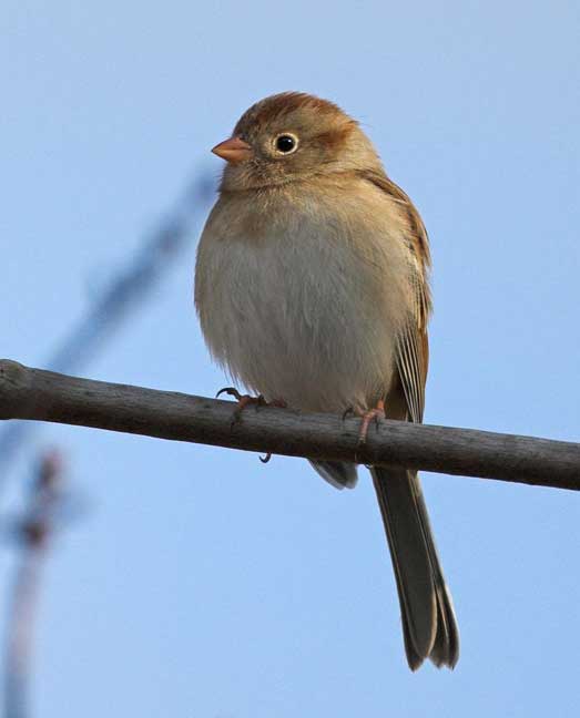
Habitats include the lake itself, there are usually Canada Geese, Mallards, and Wood Ducks along with Green and Great Blue Herons. Bald Eagles and Osprey are likely to fly over hunting for fish. We will walk along field habitat where Field Sparrows, Tree Swallows, House Wrens, Willow Flycatchers, Yellow-breasted Chats, Brown Thrashers, Northern Mockingbirds, Yellow-throated Vireos, etc. nest. We will then come to a wooded section of the trail where all your expected woodland birds also nest (we had numerous White-eyed Vireos last year and a Black-and-white Warbler the last two years). Spotted and Solitary Sandpipers are likely, as well as numerous warblers.
Composting restrooms are available at the meeting location.
ENLOW FORK, GREENE COUNTY
Led by Marjory Howard and members of the Ralph Bell Bird Club, rkbbirdclub@yahoo.com
Time: 7:30 AM
Saturday – Meet at the parking area, directions below.
Coordinates for parking area: 39.961263, -80.461824
Enlow Fork natural area is a beautiful stream valley known for the abundance of spring wildflowers and Ohio Buckeye, a rare tree in Pennsylvania. There is a brushy field near the beginning of the trail and the remainder of the valley is forested. The stream supports various amphibians including Red-spotted Newt and American Toad.
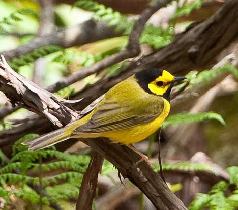
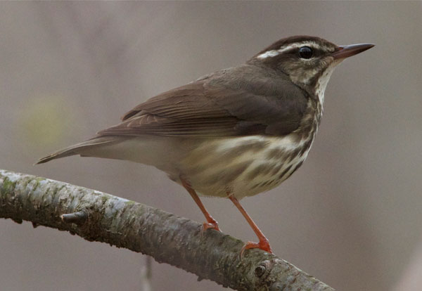
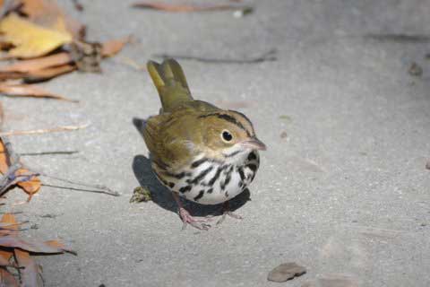
Some expected birds include Bald Eagle, Eastern Wood-Pewee, Acadian Flycatcher, White-eyed Vireo, Yellow-throated Vireo, Wood Thrush, Baltimore and Orchard Orioles, Louisiana Waterthrush, Ovenbird, Black-and-white Warbler, Cerulean Warbler, Hooded Warbler, Kentucky Warbler, Scarlet Tanager and Rose-breasted Grosbeak.
Directions:
Take I-79 south to I-70 west at Washington, Pa. Get off I-70 west onto Route 40 east. Turn right onto Franklin Farms Road just past Washington Crown Center. After a mile or so, you’ll make a right onto Route 18 south.
Follow Route 18 south through Prosperity and Old Concord into Greene County. About a mile after you enter Greene County, Route 18 makes a very sharp curve to the left at Beulah Church. Make a right onto the road where there’s a sign pointing to Ryerson Station State Park (be careful not to take the first right turn) just before the cemetery. Follow that road to Graysville (there is a point where the main road goes to the right, so be sure to stay on that).
When you come to a T in Graysville, make a right on an unnamed street and look for the signs that point to Route 21 west. Take Route 21 west for a couple miles toward Wind Ridge. Right before Wind Ridge, make a right onto Nebo Ridge Road (there is a farmhouse here on the right with stone siding on it).
Follow Nebo Ridge Road for several miles. The road will make a sweeping curve to the left and you’ll come to a group of houses (old cars and junk lying around). Turn right onto Walker Hill Road. Go about 1/8th mile, make a sharp left onto Smoky Row Lane (formerly a rugged dirt road; paved in 2014!) at the sign for the state game lands; follow that to down the hill, through an S curve at the coal mine facility, then onto Enlow Fork. Go as far as you can go till you come to a gate and parking lot. Do not stop at the first lot on the left or you’ll have a few hundred yards of walking to do.
The dirt trail is level and easy to hike. There are no restrooms at the site.
HILLMAN STATE PARK, WASHINGTON COUNTY
Led by Adrian Fenton
Saturday, 7:00 am
Meet along Steubenville Pike at: 40.435710, -80.406611
This is an undeveloped state park that is also a State Game Lands. The area features a variety of habitats including marshes, large ponds, pine plantations, grassland, shrub land and woods. Birding is mainly done along the gravel roads through the area. There are numerous areas to explore. Grassland access is on dirt paths. Note the area has numerous ticks, so staying on the road and trails is recommended. The trail through the grassland can be muddy if we have rain.
Saturday will be a driving tour of the area. Birding will primarily be along the paved and gravel roads through the park and on trails through grasslands.
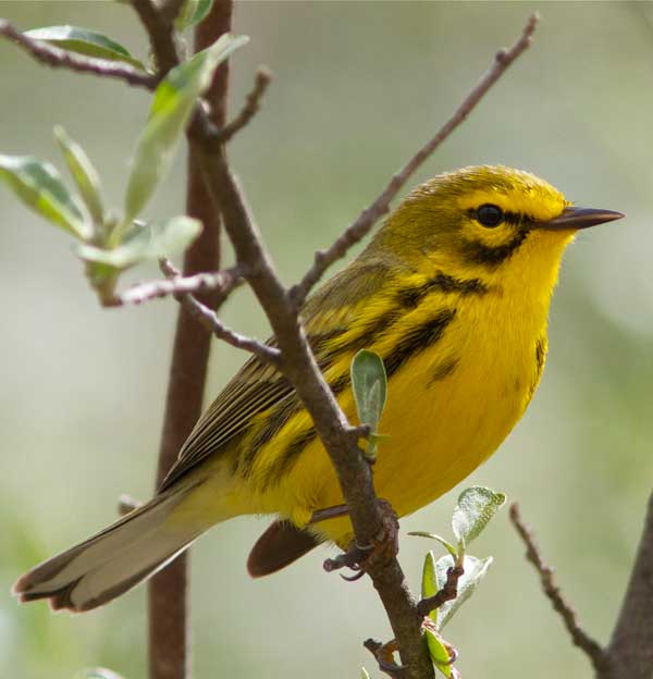
The grasslands are home to grassland sparrows, the shrub areas feature Black-billed Cuckoo, White-eyed Vireos, Blue-winged Warblers and Brown Thrashers. Prairie Warblers may be found. Typical forest birds include Wood Thrush, Scarlet Tanager, Hooded Warbler, Ovenbird, Rose-breasted Grosbeak, etc. There is a large Great Blue Heron Rookery that’s easily accessible.
Many years ago a large pine plantation was found to support breeding Red-breasted Nuthatches, Blue-headed Vireos, Hermit Thrushes and Pine Warblers. This is very unusual for a low elevation location. The pines give the feeling of being in the northern woods.
MINGO CREEK COUNTY PARK, WASHINGTON COUNTY
Led by John Flannigan
Saturday – Time: 8:00 am
Meet at Mingo Ebeneezer covered Bridge parking lot.
From Mingo Creek Road -turn onto Park View Rd. At sign -Shelters 3-4-5-6 turn onto Ebeneezer covered bridge then turn right into the parking lot.
Coordinates: 40.191977, -80.041295
Second part of the outing will begin at Mingo Observatory Parking Lot.
From Mingo Creek road turn where the metal directory sign indicates Observatory onto Mansion Hill Road until you see a log cabin with a metal roof. Park in front at the lot. Coordinates: (40.2096033,-80.0187523).
There are two sections of the park that we will bird. One is a wooded trail that passes through a pine forest, brushy habitat and crosses a creek. Next is Chapel Hill road then a deciduous forest ascending in elevation. This trail is probably 2 miles one way. It is moderately difficult with some rocky areas and exposed tree roots to navigate. Birds expected are: Yellow throated, Red-eyed and White-eyed vireos, Scarlet Tanager, Rose-breasted Grosbeak, Wood Thrush, Cerulean, Kentucky, and Hooded warblers plus possibly late migrants such as Black throated Blue and Blackpoll warblers. Location is the parking lot after passing through the Ebenezer Covered Bridge.
The second section is the Observatory which consists of a large brushy field with level pathways bisecting bushy habitat that supports Common Yellowthroat, Brown Thrasher, Field Sparrow, Yellow breasted Chat, Blue winged Warbler and possibly Prairie Warblers (bred here recently). This trail is level for the most part and maybe one mile in length. Location is off Mingo Creek Road which is the main road through the park. Turn up Mansion Hill Road just past the Henry Covered Bridge. Drive nearly all the way to the end and a parking lot will be visible shortly after passing shelter #10.
NATIONAL AVIARY, PITTSBURGH, ALLEGHENY COUNTY
700 Arch Street, Pittsburgh, PA 15212
www.aviary.org
Leader: Bob Mulvihill (Robert.Mulvihill@aviary.org)
Saturday – Meet at the Aviary (700 Arch St, Pittsburgh, PA 15212) at 9:30 AM
Cost: $17.00 per person.
This is a special tour of the National Aviary that features three exciting experiences.
1) 9:30 am National Aviary Ornithologist Robert Mulvihill will greet you before you take a special tour of the National Aviary led by either our head of Animal Programs or Animal Collections (based on their availability) that will include feedings in habitats (Wetlands, Tropical Rainforest, and Grasslands) as they give insights into our habitats and conservation work.
2) 11:00 am Habitat Heroes, a live bird show where Bald Eagles and Eurasian Eagle Owls fly overhead as audience members learn about their amazing adaptations and their importance on our shared ecosystem in our theater.
3) 11:30 am An exciting Animal Ambassador Meet and Greet in our theater.
You are welcome to tour habitats on your own after the tour, or have lunch at Atria’s café in the aviary.
PANHANDLE TRAIL, MIDWAY, BULGUR AREA, WASHINGTON COUNTY
Led by Michelle Kienholz and Dan Mendenhall
Saturday, 7:30 am
Meet at the hotel.
The Panhandle Trail is a 29 mile rails-to-trails passageway from Collier Township, PA to Collier’s WV. Between Midway and Bulgur, the trail passes by grassland and shrub habitats and is an excellent place to find flycatchers, vireos, both oriole species, mimids and grassland species including Henslow’s and Grasshopper Sparrows, Eastern Meadowlark and the featured bird of the meeting, Bobolink. Northern Harrier and Short-eared Owls are found here in winter.
This is an easy level walk along a paved trail. There is a port-a-john at the parking lot and a Valero gas station nearby in Midway. If you arrive late, simply turn right on the trail out of the parking lot and walk west until you meet the group. This is an approximately 2-3 hour out and back outing, approximately 3 miles round trip. Minimal shade, so dress for weather and bring water.
Parking lot coordinates: 40.3695523, -802924633 (Midway Mile 10.6 parking lot off Prospect Street, not off N. Main Street).
PETER’S LAKE PARK, WASHINGTON COUNTY
Led by Trip Bondi
Saturday – Time: 7:00 am
Meet at Peter’s Lake Park. Coordinates: 40.2579265, -80.1093942.
This 189-acre township park surrounds the Washington Reservoirs. The habitat is mainly woodland with the two reservoirs. Great Blue and Green herons can be expected, all five of the expected woodpeckers breed here. Other species include Hooded Warbler, Eastern Kingbird, Acadian Flycatcher, and Great Crested Flycatcher. Wood Thrushes are very common.
Walking is easy on level trails. Porta Johns are available in the park. There are options for restrooms nearby.
RACCOON CREEK STATE PARK, BEAVER COUNTY
Led by Eric Hall and Mark VanderVen
Saturday 7:00 am
Meet at the Wildflower Reserve Parking Lot along Route 30. Coordinates: 40.5071308, -80.3638852.
Raccoon Creek State Park is one of Pennsylvania’s largest state parks. It features a variety of habitats and a 101-acre lake as well as a wildflower reserve with over 700 plants on the list. The wildflower reserve is a good place to find Cerulean Warblers, Yellow-throated Warblers and Louisiana Waterthrush along Raccoon Creek. Other warblers that breed in the park include Ovenbird, Northern Parula, American Redstart, Hooded Warbler, Yellow Warbler and Blue-winged Warbler. Black-throated Green Warbler and Kentucky Warbler are possible. Osprey are often seen at the lake. Red-eyed and Yellow-throated Vireos and Wood Thrushes should be easily found. The trip leaders will try to visit as many habitats as possible during the trips.
Restrooms are available at the Wildflower Reserve and at the Park Office.
SETTLER’S CABIN PARK, ALLEGHENY COUNTY
Led by Malcolm Kurtz
Saturday – Time: 8:00 am
Meet at the Park Office just inside the entrance to the park on Ridge Road.
Coordinates 40.433105, -80.149497
Located off I-376 on 1,610 acres in the Collier, North Fayette, and Robinson Townships in Western Allegheny County, Settlers Cabin Park has a 1780 log cabin that archaeologists at Carnegie Mellon University helped identify and gives the park its name.
While some areas of the park were historically known for oil and coal mining, Settlers Cabin Park has since been reforested and has some untouched, rugged areas. The park is mostly forest with some brushy areas along the roadsides. Expect typical woodland birds. This is one of the locations in Allegheny County that has a population of breeding Ovenbirds. A Swainson’s Warbler was discovered here twice over the years.
SGL 117, WASHINGTON COUNTY
Led by Mike Fialkovich
Saturday, 7:00 am
Meet at one of the parking areas at the gamelands.
Parking lot coordinates: 40.406233, -80.383525
This extensive game lands in the northern part of Washington County features grassland, shrub habitat and forest.
A great variety of birds breed here. Specialties of this habitat include Henslow’s Sparrow, Prairie Warbler, Blue-winged Warbler, Yellow-breasted Chat, both cuckoo species, Wild Turkey, Eastern Kingbird, Orchard Oriole, Scarlet Tanager and many more.
Walking will be easy on a level gravel road with one minor slope. No restrooms at the site but there are gas stations and a McDonald’s nearby at the Imperial Exit of Route 22/30.
SGL 232, WASHINGTON COUNTY
Led by Jeff Kenney and Angela Romanczuk, 610-804-4634
Saturday – 7:00 am
Coordinates for meeting location at a roadside pull-off at the gamelands: 40.1780846, -80.4409822
This gamelands offers a variety of breeding birds. The habitat is wooded riparian hillside. Target species include Cerulean Warbler, Hooded Warbler, Yellow-throated Warbler and other forest birds.
Walking will be on a road.
There are no restrooms at the site.
Sunday, June 2, 2024
BOYCE-MAYVIEW PARK and WINGFIELD PINES
Led by Shannon Thompson
Sunday – Meet at the hotel at 6:30 AM
Boyce-Mayview Park is on a former hospital property in southern Allegheny County that is now a public park in Upper St. Clair. Habitats include several ponds and wetlands, open fields and forest. Spring offers a great display of wildflowers and migrating warblers. Some rare herons have occurred at this park including Little Blue Heron and Black-crowned Night-Heron (rare in southwestern PA). Barred Owls are resident. Trials vary from wide and level to narrow and hilly, so the difficulty is moderate in some places. Trails are all dirt and may be muddy in some places.
Wingfield Pines is just across the road from Boyce-Mayview and is connected to Boyce-Mayview by Chartiers Creek. Wingfield is owned by the Allegheny Land Trust and the site was a former golf course. It’s now a nature preserve with numerous ponds and a cattail marsh. The ponds are used to treat acid mine runoff from the surrounding land. The settling ponds allow the iron oxide in the water to settle out before the water continues to flow into Chartier’s Creek. The marshes featured breeding Sora and Virginia Rail in recent years. Yellow-throated Warblers breed in the Sycamores. Both orioles and Eastern Kingbird breed here. Rarities include Black Tern, American and Least Bittern, the first county record of Snowy Egret and Prothonotary Warbler.
Restrooms are available at the center in Boyce-Mayview Park and at nearby gas stations a short distant from the park at the Bridgeville Exit of I-79.
Parking area GPS Coordinates: 40.336014, -80.111409
CANONSBURG LAKE, WASHINGTON COUNTY
Led by Trip Bondi
Sunday – Time: 7:00 am
Meet at Canonsburg Lake. Coordinates: 40.2700066, -80.1340152.
This small lake is popular with fishermen and is well known for the Mottled Duck that spent weeks here in May 2023.
This is easy walking on grass along the lake shore. Eastern Kingbirds, swallows, Great Blue and Green herons and a Bald Eagle nest are features of this location. The eagles are accustom to people so close views are often experienced.
CEDAR CREEK PARK, WESTMORELAND COUNTY
Led by Alex Busato, 724-963-6612
Sunday – 8:00am
Meet at the lower parking lot and Great Allegheny Passage trail access (40.176282, -79.770165)
This will be an approximately 2.5 mile round trip hike with a variety of forest and meadow habitat.
We’ll first walk along the Great Allegheny Passage trail along the Youghiogheny River west toward its intersection with the Cedar Creek Gorge. Spotted Sandpiper, Common Merganser, Cedar Waxwing, and Tree Swallows are common along the Yough riverfront. We will then ascend up the Cedar Creek Gorge trail along the stream (some wet and muddy spots and moderately steep) through deciduous forests and past scenic cascades. In the forest we are likely to encounter Baltimore Orioles, Scarlet Tanager, Acadian Flycatcher, Blue-gray gnatcatcher, Rose-breasted Grosbeak, Louisiana Waterthrush, Yellow-throated Warbler, American Redstart, Warbling Vireo, and Yellow-throated Vireo, among others. From here we will ascend a short section of uneven and rough trail up to a field with a mowed path along the Mon-Valley RC Airfield. In the field we are likely to see Field Sparrows and other sparrows, Eastern Meadowlark, Eastern Bluebirds, Red-winged Blackbirds, Common Yellowthroat, and more. Lastly, we’ll make our way back down the roadway to the lower parking lot.
There are restrooms in the park.
CROSS CREEK COUNTY PARK, WASHINGTON COUNTY
Led by Fred Kachmarik and Alyssa Nees
Sunday – Time: 6:30 am
Meet at Boat Launch 3, Google Map and Coordinates: https://maps.app.goo.gl/GJpC34Q1CgMUGn3L9, 40.258515, -80.382666
This county park features a lake and trails through various habitats. We will be walking the lakeshore trail. Walking is easy but there may be mud if there is a lot of rain.
Habitats include the lake itself, there are usually Canada Geese, Mallards, and Wood Ducks along with Green and Great Blue Herons. Bald Eagles and Osprey are likely to fly over hunting for fish. We will walk along field habitat where Field Sparrows, Tree Swallows, House Wrens, Willow Flycatchers, Yellow-breasted Chats, Brown Thrashers, Northern Mockingbirds, Yellow-throated Vireos, etc. nest. We will then come to a wooded section of the trail where all your expected woodland birds also nest (we had numerous White-eyed Vireos last year and a Black-and-white Warbler the last two years). Spotted and Solitary Sandpipers are likely, as well as numerous warblers.
Composting restrooms are available at the meeting location.
ENLOW FORK, GREENE COUNTY
Led by Marjory Howard and members of the Ralph Bell Bird Club, rkbbirdclub@yahoo.com
Time: 7:30 AM
Sunday – Meet at the parking area, directions below.
Coordinates for parking area: 39.961263, -80.461824
Enlow Fork natural area is a beautiful stream valley known for the abundance of spring wildflowers and Ohio Buckeye, a rare tree in Pennsylvania. There is a brushy field near the beginning of the trail and the remainder of the valley is forested. The stream supports various amphibians including Red-spotted Newt and American Toad.
Some expected birds include Bald Eagle, Eastern Wood-Pewee, Acadian Flycatcher, White-eyed Vireo, Yellow-throated Vireo, Wood Thrush, Baltimore and Orchard Orioles, Louisiana Waterthrush, Ovenbird, Black-and-white Warbler, Cerulean Warbler, Hooded Warbler, Kentucky Warbler, Scarlet Tanager and Rose-breasted Grosbeak.
Directions:
Take I-79 south to I-70 west at Washington, Pa. Get off I-70 west onto Route 40 east. Turn right onto Franklin Farms Road just past Washington Crown Center. After a mile or so, you’ll make a right onto Route 18 south.
Follow Route 18 south through Prosperity and Old Concord into Greene County.
About a mile after you enter Greene County, Route 18 makes a very sharp curve to the left at Beulah Church. Make a right onto the road where there’s a sign pointing to Ryerson Station State Park (be careful not to take the first right turn) just before the cemetery. Follow that road to Graysville (there is a point where the main road goes to the right, so be sure to stay on that).
When you come to a T in Graysville, make a right on an unnamed street and look for the signs that point to Route 21 west. Take Route 21 west for a couple miles toward Wind Ridge. Right before Wind Ridge, make a right onto Nebo Ridge Road (there is a farmhouse here on the right with stone siding on it).
Follow Nebo Ridge Road for several miles. The road will make a sweeping curve to the left and you’ll come to a group of houses (old cars and junk lying around). Turn right onto Walker Hill Road. Go about 1/8th mile, make a sharp left onto Smoky Row Lane (formerly a rugged dirt road; paved in 2014!) at the sign for the state game lands; follow that to down the hill, through an S curve at the coal mine facility, then onto Enlow Fork. Go as far as you can go till you come to a gate and parking lot. Do not stop at the first lot on the left or you’ll have a few hundred yards of walking to do.
The dirt trail is level and easy to hike. There are no restrooms at the site.
HILLMAN STATE PARK, WASHINGTON COUNTY
Led by Adrian Fenton
Sunday, 7:00 am
Meet along Steubenville Pike at: 40.435710, -80.406611
This is an undeveloped state park that is also a State Game Lands. The area features a variety of habitats including marshes, large ponds, pine plantations, grassland, shrub land and woods. Birding is mainly done along the gravel roads through the area. There are numerous areas to explore. Grassland access is on dirt paths. Note the area has numerous ticks, so staying on the road and trails is recommended. The trail through the grassland can be muddy if we have rain.
Saturday will be a driving tour of the area. Birding will primarily be along the paved and gravel roads through the park and on trails through grasslands.
The grasslands are home to grassland sparrows, the shrub areas feature Black-billed Cuckoo, White-eyed Vireos, Blue-winged Warblers and Brown Thrashers. Prairie Warblers may be found. Typical forest birds include Wood Thrush, Scarlet Tanager, Hooded Warbler, Ovenbird, Rose-breasted Grosbeak, etc. There is a large Great Blue Heron Rookery that’s easily accessible.
Many years ago a large pine plantation was found to support breeding Red-breasted Nuthatches, Blue-headed Vireos, Hermit Thrushes and Pine Warblers. This is very unusual for a low elevation location. The pines give the feeling of being in the northern woods.
IBA 80 / GREENCOVE WETLANDS
Led by Larry Helgerman, 412-508-0321
Sunday – Meeting time: 7:15 am
Meeting Location: Historic S-Bridge parking lot on SR-221, Coordinates: 40.140717, -80.349963
I-70 South from the hotel to Exit 11 (Taylorstown Exit), head north on SR-221 approximately 9/10 of a mile to the S-Bridge parking lot on the left, lot is just past the intersection with SR-40 (blinking red light).
From the S-bridge, we will carpool 5 miles to our birding areas. We will begin birding in the upper fields of PA Game Lands 232 (1,250 ft elevation) and work our way down to Buffalo Creek (850 ft elevation). We will be carpooling through our birding route, stopping in the various habitats, walking short distances at each stop. Walking will be mostly on stone roads, some with gentle grades.
Habitats include upland fields, early successional forest, mature woodlands, riparian zones, and lowland wetlands.
Outing difficult rating: 3 or less (1 to 5 scale). Be prepared to walk with sturdy shoes/boots. Bring water and snacks if you like. There are no restrooms in the Game Lands.
Target birds include four species of swallows including Purple Martin, both species of cuckoos, Acadian and Willow Flycatchers, Brown Thrasher, Wood Thrush, White-eyed, Warbling and Yellow-throated Vireos, Warblers including Ovenbird, Louisiana Waterthrush, Blue-winged Warbler, Black-and-white Warbler, American Redstart, Cerulean Warbler, Northern Parula, Yellow-throated Warbler. Scarlet Tanager, Rose-breasted Grosbeak, Indigo Bunting, Bobolink, Eastern Meadowlark and both orioles nest in the area.
MINGO CREEK COUNTY PARK, WASHINGTON COUNTY
Meet at Mingo Ebeneezer covered Bridge parking lot.
From Mingo Creek Road -turn onto Park View Rd. At sign -Shelters 3-4-5-6 turn onto Ebeneezer covered bridge then turn right into the parking lot.
Coordinates: 40.191977, -80.041295
Second part of the outing will begin at Mingo Observatory Parking Lot.
From Mingo Creek road turn where the metal directory sign indicates Observatory onto Mansion Hill Road until you see a log cabin with a metal roof. Park in front at the lot. Coordinates: (40.2096033,-80.0187523).
There are two sections of the park that we will bird. One is a wooded trail that passes through a pine forest, brushy habitat and crosses a creek. Next is Chapel Hill road then a deciduous forest ascending in elevation. This trail is probably 2 miles one way. It is moderately difficult with some rocky areas and exposed tree roots to navigate. Birds expected are: Yellow throated, Red-eyed and White-eyed vireos, Scarlet Tanager, Rose-breasted Grosbeak, Wood Thrush, Cerulean, Kentucky, and Hooded warblers plus possibly late migrants such as Black throated Blue and Blackpoll warblers. Location is the parking lot after passing through the Ebenezer Covered Bridge.
The second section is the Observatory which consists of a large brushy field with level pathways bisecting bushy habitat that supports Common Yellowthroat, Brown Thrasher, Field Sparrow, Yellow breasted Chat, Blue winged Warbler and possibly Prairie Warblers (bred here recently). This trail is level for the most part and maybe one mile in length. Location is off Mingo Creek Road which is the main road through the park. Turn up Mansion Hill Road just past the Henry Covered Bridge. Drive nearly all the way to the end and a parking lot will be visible shortly after passing shelter #10.
PANHANDLE TRAIL, MIDWAY, BULGUR AREA, WASHINGTON COUNTY
Led by Ezra White and Michael David
Sunday – Meet at the hotel at 7:30 AM
The Panhandle Trail is a 29 mile rails-to-trails passageway from Collier Township, PA to Collier’s WV. Between Midway and Bulgur, the trail passes by grassland and shrub habitats and is an excellent place to find flycatchers, vireos, both oriole species, mimids and grassland species including Henslow’s and Grasshopper Sparrows, Eastern Meadowlark and the featured bird of the meeting, Bobolink. Northern Harrier and Short-eared Owls are found here in winter.
This is an easy level walk along a paved trail. There is a port-a-john at the parking lot and a Valero gas station nearby in Midway. If you arrive late, simply turn right on the trail out of the parking lot and walk west until you meet the group. This is an approximately 2-3 hour out and back outing, approximately 3 miles round trip. Minimal shade, so dress for weather and bring water.
Parking lot coordinates: 40.3695523, -80.292463 (Midway Mile 10.6 parking lot off Prospect Street, not off N. Main Street).
RACCOON CREEK STATE PARK, BEAVER COUNTY
Led by Kate St. John
Sunday: 7:30 am
Meet at the Wildflower Reserve Parking Lot along Route 30. Coordinates: 40.5071308,-80.3638852.
Raccoon Creek State Park is one of Pennsylvania’s largest state parks. It features a variety of habitats and a 101-acre lake as well as a wildflower reserve with over 700 plants on the list. The wildflower reserve is a good place to find Cerulean Warblers, Yellow-throated Warblers and Louisiana Waterthrush along Raccoon Creek. Other warblers that breed in the park include Ovenbird, Northern Parula, American Redstart, Hooded Warbler, Yellow Warbler and Blue-winged Warbler. Black-throated Green Warbler and Kentucky Warbler are possible. Osprey are often seen at the lake. Red-eyed and Yellow-throated Vireos and Wood Thrushes should be easily found. The trip leaders will try to visit as many habitats as possible during the trips.
Restrooms are available at the Wildflower Reserve and at the Park Office.
RYERSON STATION STATE PARK, GREENE COUNTY
Led by Brian Byrnes and Katie Fallon
Sunday: 8:00 am
Meet at the Park Office along Bristoria Road. Coordinates: 39.886335, -80.444983.
Here’s an opportunity to increase your Greene County list before heading home. This park in the extreme Southwestern part of the state offers four major habitats to explore including forest, spruce plantations, wet valley bottoms and brushy fields.
Trails are listed as easy for the most part. Restrooms are at the park office.
SETTLER’S CABIN PARK, ALLEGHENY COUNTY
Led by Malcolm Kurtz
Sunday – Time: 8:00 am
Meet at the Park Office just inside the entrance to the park on Ridge Road.
Coordinates 40.433105, -80.149497
Located off I-376 on 1,610 acres in the Collier, North Fayette, and Robinson Townships in Western Allegheny County, Settlers Cabin Park has a 1780 log cabin that archaeologists at Carnegie Mellon University helped identify and gives the park its name.
While some areas of the park were historically known for oil and coal mining, Settlers Cabin Park has since been reforested and has some untouched, rugged areas. The park is mostly forest with some brushy areas along the roadsides. Expect typical woodland birds. This is one of the locations in Allegheny County that has a population of breeding Ovenbirds. A Swainson’s Warbler was discovered here twice over the years.
SGL 117, WASHINGTON COUNTY
Led by Michelle Kienholz and Dan Mendenhall
Sunday – Meet at one of the parking areas at the gamelands a 7 AM.
Parking lot coordinates: 40.406233, -80.383525
This extensive game lands in the northern part of Washington County features grassland, shrub habitat and forest.
A great variety of birds breed here. Specialties of this habitat include Henslow’s Sparrow, Prairie Warbler, Blue-winged Warbler, Yellow-breasted Chat, both cuckoo species, Wild Turkey, Eastern Kingbird, Orchard Oriole, Scarlet Tanager and many more.
Walking will be easy on a level gravel road with one minor slope. No restrooms at the site but there are gas stations and a McDonald’s nearby at the Imperial Exit of Route 22/30.
SGL 232, WASHINGTON COUNTY
Led by Jeff Kenney and Angela Romanczuk, 610-804-4634
Sunday – 7:00 am
Coordinates for meeting location at a roadside pull-off at the gamelands: 40.1780846, -80.4409822
This gamelands offers a variety of breeding birds. The habitat is wooded riparian hillside. Target species include Cerulean Warbler, Hooded Warbler, Yellow-throated Warbler and other forest birds.
Walking will be on a road.
There are no restrooms at the site.