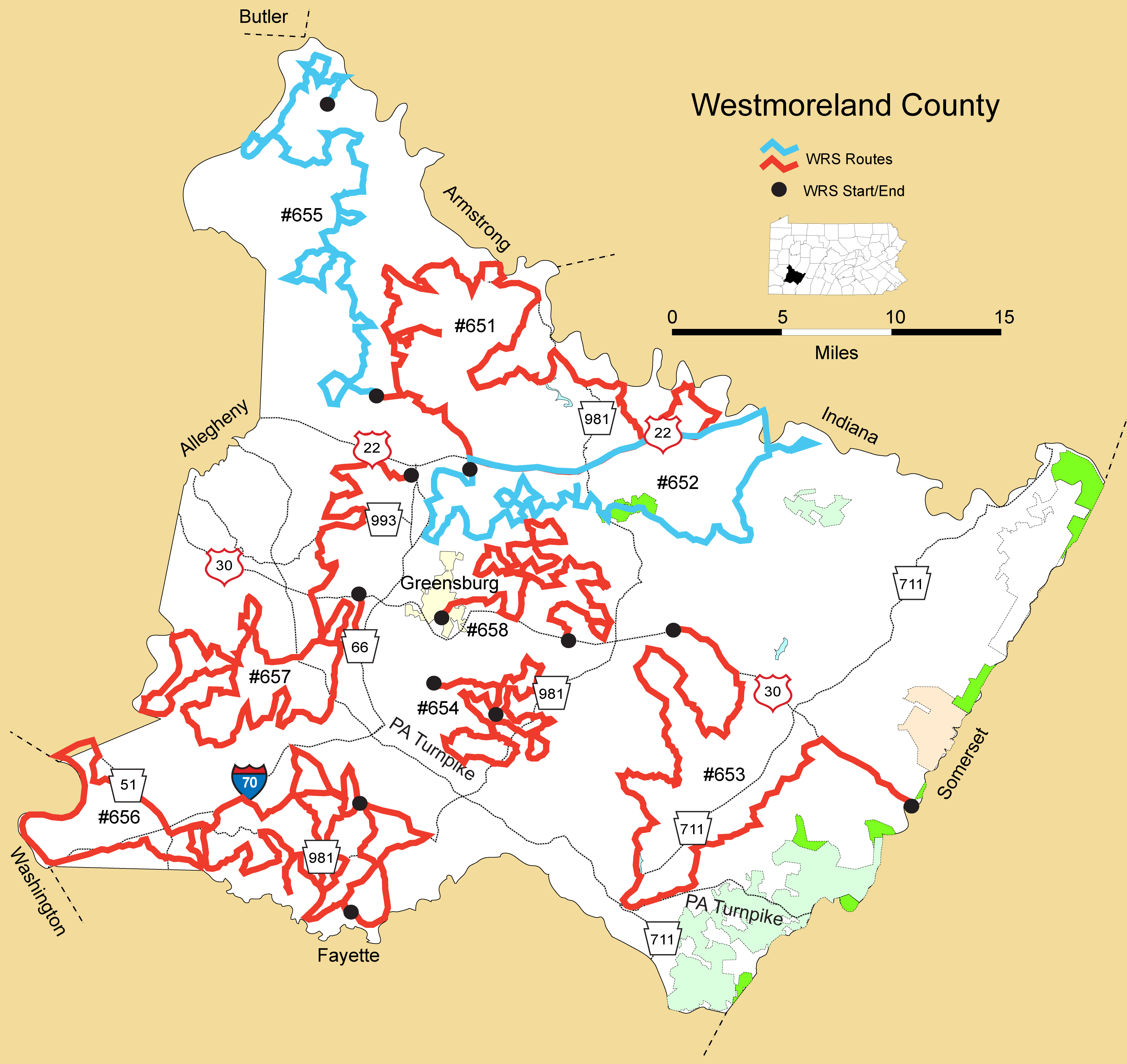
Details
Route#: 651
Route Name: Slickville
Compiler: Tom Kuehl
Directions: Start – Kuehl Property at 3615 Hilty Road
Go north on Hilty Rd
Tale the immediate right to go up the hill on Silvis to turn right to go north on PA 66
Turn right onto Turack Road and drive the circle back towards PA 66
Turn right on Mamont Road as you approach PA 66
Turn right on George as you approach PA 286
Turn left onto Evans
Turn right on PA 286 and take in over the Beaver Run Reservoir
Turn left onto Beaver Drive after crossing the water – take it to the end and turnaround
Drive west on PA 286 back to Mamont
Turn right on Mamont to go to PA 66
Go north on PA 66 and turn onto Fox Run Road at Poke Run
Drive up Fox Road (no Poke Run Church)
Drive past Young Drive on the left
Turn left on Walker Road
Bear right off Walker and onto Zubal Road to go north back to PA 66
Take right onto PA 66 and then take the immediate right onto the ramp to take PA 380 east
Drive on PA 380 to the Beaver Run Reservoir Overlook
Turn around and backtrack on PA 380 and take the first right on Beaver Run Road
Bear right on Pleasant View Drive
After crossing Beaver Run turn left at T to take Coal Hollow Road to PA 819
After a short drive south on PA 819 bear right onto Muffley Hollow Road
Turn left onto Carnahan Road and drive east towards Perryville
Turn left to take PA 819 north
Bear left onto McCreary Road
Cross over PA 819 and go due north on Bell Point Road (T 811 – per Google Maps)
At T turn right onto Larimer Road to drive through the woods to the Kiski River at Salina
Turn right onto Main Street in Salina and drive southeast to PA 981
Turn left to drive east on PA 981 and drive past PA 156 and Tony's Dog House on the left
Turn right to drive southeast on Substation Road – appears to become Waukena Road
Cross straight over PA 286 at Waukena Road (BBS route starting point). Go past Fairbanks on left
Bear to the right (don't turn left at a T) – appears that it becomes Ridge Road
Go past Steele Road to the right and then bear left (T810 – Steele Road) to go south to Main Street in Slickville
Turn right onto Main Street to drive through Slickville
Turn left to go southeast on PA 819
Go up the hill and after passing the Legion Hall turn left on Walter Road
Bear left onto Maple Lodge Road to go the bike trail parking lot east of Slickville
At the trail parking lot turn right onto Bortz Road
Turn left on Sawmill Road (conflict with Google Maps – but after turning left at a T this should turn in to Loyalhanna Dam Road, with the Dam on the right shortly after – after checking out the dam area continue down to the Eagle-Watch bridge and then continue to PA 981).
Turn right onto PA 981
For a side trip – turn left at Quary sign to drive to and backtrack from the little town on Moween Road – NOT WORTH IT SO STOPPED DOING THIS.
Otherwise continue driving in a southeast direction until going past the convenience store and turning left on Tunnelton Road.
Drive to Tunnelton Bridge and then turn right to go up the gorge on Pump Station Road
Turn left at T onto Weimer Road
Drive in southwest direction (do not turn right onto Stevenson to continue towards PA 22)
Turn left onto Number 10 School Road
At T turn left onto Livermore Road to trail parking lot
Turn right before RR tracks – to stay on Livermore Road
Drive Livermore Road in south east direction to Westinghouse Road
Turn right onto Westinghouse to go back towards PA 22
Turn right on Stark Road before reaching PA 22
Turn left onto Livermore Road and take it back to PA 22
Turn right onto PA 22
Turn right onto Rushmore Road
Go past Short-cut Road on left and continue to PA 981
Turn left onto PA 981 to go south to New Alexandria/PA 22
Turn fight to go west on PA 22
Turn right onto White Thorn Road
Turn left on Davis Road
Follow creek by bearing left – Deerfield per sign (White Thorn per Google Maps) – driving west
Turn right to drive north onto Fenneltown (Congruity) Road
Turn left onto Kaufman Road
Turn left onto PA 819 and take it to 5-Points
Turn right onto Trees Mills Road
Left onto Athena
Right onto Defrancies
Right onto Lauffer Mine Road
Right on Wee to take a right on Story Road
Left onto Thorne Run Road
Left onto PA 66 – south
Right onto Italy at Delmont Vet Hospital
Bear left to stay on Italy
Right onto Kemerer Road
Right onto Kemerer Hollow Road
Go straight at next intersection onto Hilty and back to the Kuehl starting point
Route#: 652
Route Name: Crabtree
Compiler: Tom Kuehl
Directions: Start at Intersection of PA 66 and PA 22
Go east on PA 22
Turn right onto Sauls Road – drive up the hill to check out the area and then return to PA 22
At Five-Points turn right to go south on PA 819
Turn right on Bogs Hollow Road
Turn right on Sauls Road – check out the pines on the right and then return to Boggs Hollow
Take Bog Hollow Road all the way to PA 22 – turnaround and turn right onto Jobes Road
Turn left onto Crooked Creek Road
Turn right onto Beaver Run Road
Turn left onto Greene Road
Option to turn right to go to Mcllvaine Road to check out to PA 66 – but don't continue on Mcllviane
Turn right onto Shutt Road
Turn left onto Old Forbes Trail – passing the Hempfield park on the right
Turn left on Stoney Springs Road
Turn right onto Beaver Run Road and continue to PA 819
Turn right to go south on PA 819 and continue to Forbes Road
Turn left onto Firestation Road and stay right to go around the town and follow Crabetree Creek on the right
Continue to Totteridge Golf course to Hannastown Road
Turn left at the T onto Hannastown Road
Turn right onto Helen Drive
Turn left at T to proceed on Old Hannastown Road toward Crabtree
Proceed up the hill to go up to Bardine's Smokehouse on Stevens Road
At T turn left onto Tucker Road
At T turn right on Hannastown (1055) to go past Kepple Brothers Farm
Turn right onto Hillview Drive
At T turn left onto 1022 (Tucker or Stevens) and proceed to T
Turn right onto Kemp Road
Right on Shady Lane (Note Google Maps not showing this – seems to call it Pine – T852) but worked in 2017) – Note that farm is down the hill to the right
Left onto Pine Drive (T852) and continue to PA 119 on the north end of Crabtree
Turn left to go north on PA 119 and turn right on Skyview and bear left
Turn left onto Galando Road to go to Loyalhanna Creek and follow into New Alex
Turn right onto PA 119 to PA 22
Turn right to go east PA 22
Turn right to go south on PA 381
Turn left onto Keystone State Park Road
Turn right onto Stag Road to go into the Park – Bathroom stop
Proceed through the Park and turn right back onto Keystone Park – Pittsburgh Street to New Derry
At the intersection with PA 982 in New Derry go straight to continue on Pittsburgh Street to PA 217
Turn left to go north on PA 217
Turn left onto Bergman Road
Turn right at T – Pizza Barn Road (1025) and take it north all the way to the intersection with PA 217
Turn left onto PA 217 to go north towards Blairsville, and take the first onto Torrence Road. Drive pas the hospital and then return.
Turn left to go south on PA 217 and go back on to Pizza Barn Road – a right to back up the hill
Turn right onto Derry Lane to head north back toward PA 22
Turn left onto Laughlin Farm Road
At T turn right onto Willow Run Road and drive SE to PA 982
Turn right on PA 982 to go north to PA 22
Turn left to go west on PA 22
Drive through New Alex and look for Quarry Road
Turn left onto Quarry Road
Take the sharp right onto Evergreen Road and take that to PA 819
Turn right onto PA 819 to go Five Points intersection with PA 22 – END OF ROUTE!
Route#: 653
Route Name: Ligonier Valley
Compiler: Tom Kuehl
Directions: Start – Somerset County Line on PA 30 on top of Laurel Ridge
Go west on PA 30 down Laurel Ridge towards Laughlintown
Go through Laughlintown
Turn left onto PA 381 and drive south toward Rector
Turn left after crossing Linn Run to stay on PA 381
Turn right onto Stony Lonesome Road – note that there is a 90 degree to turn to the left to stay on Stony Lonesome Road
Continue to PA 130 and turn left at T to go east on PA 130
Turn at first right onto Kregar Road
Turn left and then take the immediate right to continue south on Kregar Road
Turn right at T onto Old Franklin Road (as you approach the PA TP)
Bear right at intersection with Jones Mill/Snyder Roads to continue on Old Franklin
Then bear left to at intersection with Jones Mill Stahlstown Road to continue on Old Franklin
Continue on Old Franklin Road to PA 711
Turn right onto PA 711 to go north towards Donegal Lake / Donegal
Turn left onto Donegal Lake Road
Bear right at Y (by the Randall Reserve) to proceed on Donegal Lake Road to Four Mile Road
Turn right at T onto PA 130 and drive southeast
Take the first left turn onto (Old) Distillery Road (north and then a bend to the right to go east)
Turn left on T onto Bethel Church Road
Cross over Four Mile Run – go past Little Duquesne Lane and turn right onto Four Mile Run Road
Drive northeast on Four Mile Run and bear right at Y onto Jefferson School Road
Bear left at Y to go uphill on McDowell Road (maybe to stay on Jefferson School and not get on Darlington to the right)
Continue east on McDowell and at T turn left onto Darlington Road
At intersection turn right onto Zion Church Road – drive in a north easterly direction
At intersection with Two Mile Run Road, cross over and continue up hill on Freeman Road
Follow Freeman to PA 711 and turn right to drive south on 711
Turn right onto Slater Road, which bends left
And then turn right onto Two Mile Run Road to return to intersection Zion Church/Freeman
Proceed through intersection to continue north on Two Mile Run Road
At T turn left onto Ross Road
Turn right at T onto Darlington Road
Bear right at the end of Darlington to go east on PA 30
Exit right at Two Mile Run Road – check that out and return to cross PA 30 on short link to PA 30 West to the American Kestrel spot (maybe add a short detour to the pond behind the restaurant.
Proceed west on PA 30 to end of WRS route at the Kingston Dam.
Route#: 654
Route Name: Westmoreland Central
Compiler: Sharon Gewecke
Directions: Start: South of Greensburg PA at Rt. 819 and Albrights Lake Road
Drive south on Albrights Lake Road
Take left fork to get onto Valley Green Road
Drive through the golf course to T with Brinkerton Road
Turn right onto Brinkerton Road then after a short distance
Turn left onto Pattern Shop Road to Y-intersection with Mt. Pleasant Road
Turn right to go east on Mt. Pleasant Road
Take Y to the left to travel east on Firestone Road
Turn right onto Miscovich Road – return to Firestone after covering the habit on Miscovich Road
Turn right to continue east on Firestone Road
After a short distance turn left onto Ludwig Road
At T turn right onto Myers Road
Turn left onto Rt. 130
At the top of the hill bear right onto Clark Farm Road
At T turn left to travel north on Marguerite Lake Road (SR-2017) – after a short distance Marguerite Reservoir (drained and cattails as of 2018) will be on the right side of the road
At first intersection turn right onto Bruno Road
Bear right to continue southeasterly on Bruno Road, to continue on Coke Oven Road
At T turn right onto Marguerite Road
At first intersection turn right onto Shinsky Road (may show as T-571 per Google Maps)
At T turn left to drive south on Marguerite Lake Road (SR-2019)
At T (near Naser Foods) turn right onto Rt. 130
Take 90 Degree turn to the right to stay, and travel north on Rt. 130.
When Rt. 130 bears right, go straight/bear left to get onto Firestone Road
Take first left to drive south on Truxal Road
Merge onto Pleasant Unity Mutual Road (where it appears to turn into Beatty Road)
Take first left onto Pollins Road
Bear left to stay on Pollins Road, then bear/turn left onto Trauger Road
Turn right (to go south) at the T-intersection with Rt. 981
After a short distance turn left onto Bingham Road (may show as Trail 581 per Google Maps)
Bingham Road bends to the right, cross Sewickley Creek, a bend to the left and then a bend to the right (Google Maps may now call it Wigle Road) to come to a T
Turn right onto Hills Church Road (SR-2023) to travel in a SW direction
Turn at the first left onto Blacksmith Road (SR-2025)
Bear left at Y to stay on Blacksmith Road as you approach Mammoth Lake Park
Turn right onto County Park Road and drive through the park – go straight and bear to the right to go to the west and not immediately get onto Rt. 982. Per Google Maps the road becomes Mitkar Road and continue to the intersection with Rt. 982
Turn right to go west then north on County Road per Google Map, but may actually be Calumet/Mammoth Park Road
Take the first right turn onto Klaka Road to drive north along the border of the Park
At T turn left onto Hills Church Road
Take the first right to travel west/NW on Baker Road
Turn left at T to travel south on Rt. 981 (Mt. Pleasant Road)
After a short distance turn right onto Fairgrounds Road
Go past Sharon's home lane on right and continue to the T-intersection
Turn left at T onto Mt. Pleasant Road to drive south to Brinkerton Road
Turn left at Brinkerton Road intersection (at Post Office?) which turns into County Road/United Road to continue east to Rt. 981
Turn right to drive a short distance south on Rt. 981
Take the first left turn onto County Road/Calumet Mammoth Park Road
Take the first right turn onto Holly Place Road (SR-2023)
Drive south to go past Norvelt Golf Club to return to Rt. 981
Turn left to travel in an westerly direction on Rt. 981 South
Bear right at triangle-intersection (BP at this intersection) to go a short distance north, then
Turn left onto Hecla Road
Bear left to continue in an westerly direction on Hecla Road
Bear left again to drive south and stay on Hecla Road
At the Slovak American Club pond turn right onto SR-2010 (appears to be Hecla-Ambrust Road)
Make a 135 degree right turn to get on Udell Road
After crossing Sewickley Creek bear right onto (Ambrust)/Brinkerton Road
Take several turns to stay on Brinkerton Road all the way to continue east to the intersection with Mt. Pleasant Road
Turn lift to travel north on Mt. Pleasant Road
Take the fork to the left to get onto Greensburg Sportsman Road/becomes Freeman Road
At T turn right onto Weaver Road (Trail 573 per Google Maps)
WRS Route ends at the intersection with Mt. Pleasant Road in Mutual, Unity Township area
Route#: 655
Route Name: Westmoreland Northwest
Compiler: Tom Kuehl
Directions: Starts at Kuehl the Property, 3615 Hilty Road in Export/Murrysville and ends in the Freeport/Leechburg area
Go north on Hilty
Turn left onto Bollinger Road
Turn left at horse stables to go south on Wiestertown Road
Turn right onto Hills Church Road
At T with Windover turn right to continue on Hills Church Road
Shortly after passing Tamarack Road on the left, take the 135 degree right onto Sinan Dr, and then take the immediate left turn to proceed east on Evans Road
At first intersection you have returned to the horse stables, turn left to go north (and past the Murrysville Community Park) on Wiestertown Road
Turn left at Y to proceed north on Hilty Road
At T turn right to go east on Rt. 286 (Saltsburg Road)
Take the first left to go north on Beech Road
At T turn right to go east on Rt. 366 (Greensburg Road)
Turn left to go north on Washington Road (before reaching Rt. 66)
At T turn left to continue on Washington Road (Echo Road was closed when route was created so not an option – a future consideration to take it to Echo to Crestview and take Crestview to Utopia Road/Rt. 380)
Turn right at next Y with Woodland Park Drive to remain on Washington Road
Bear right at the next Y (Shady Lane) to remain on Washington Road
Drive in a northwest direction past several other roads, then bear right at T to take Utopia Road to proceed to Rt. 380
Turn right to go east on Rt. 380 a short distance to take the first left to go northwest on Rt. 780
Turn left onto Hunt Valley Road to drive through the Industrial Park
Turn right onto Camp Nancy Road and proceed south
Just before returning to Rt. 380 turn right onto Turkey Ridge Road
At T turn right to proceed northeast on Whitten Hollow Road
At Y bear left at Double R Lane to remain on Whitten Hollow Road
A T turn right to go east on Merwin Road (SR 4032)
At T turn left to go north on Rt. 780
Turn right onto White Cloud Road – proceed east, passing Alcoa Research then to the north after a bend to the left
At the first intersection turn right to go east on Oak Lake Road
Bear left at Y with Woodland Road and note that Oak Lake Road becomes Watson Road
Take the first left onto Willowbrook Road, and continue west to return to White Cloud Road
At T turn right to go north on White Cloud Road
Take the first right onto Markle Road to drive east to Northmoreland Park
With the lake on the right, turn left onto Air Shaft Road
Drive north on Air Shaft Road
At the T turn left to go west and proceed past Pounds Turkey Farm
Take the first right to proceed north on Shaner Road
Bear left onto Chamberlain Street and proceed to Rt. 356
Turn left before the Crossroads Inn and proceed on Shearsburg Road
Turn left onto White Cloud to drive south
Turn right onto Copeland Road and proceed to the south
At T turn right onto Melwood Road and proceed west to Rt. 56, then cross Rt. 56 to proceed on Spooky Hollow Road
Very shortly, bear right to proceed north on Hulton Road
Turn left onto Dairy Farm Road (found a pair of RS Hawks here in 2019)
At T turn left onto Garvers Ferry Road
Follow right bend on Garvers Ferry Road (a park on the left at you descend on Garvers Ferry Road)
Then turn right at Y to proceed north to take Upper Braeburn Road/Edgecliff Road towards the Allegheny River
Bear right to proceed along the Allegheny River on Lowe's Road
Bear right onto Braeburn Road and take that to the east to return to Garvers Ferry Road
Turn left to drive north east on Garvers Ferry Road
After a sharp bend to the right, turn left onto White Cloud Road
Cross over Rt. 356 and turn right onto Brown Road
Turn left onto Lucesco Road
Turn left to remain on Lucesco and then left on Crain Road to return to Rt. 356
Turn left to proceed south on Rt. 356
Turn left onto Bagdad Road and proceed east to the Kiskiminetas River, and then take the bend to the right onto Indian Hill Road and continue back to Rt. 356 for the end of the route.
Route#: 656
Route Name: Southwestern Westmoreland
Compiler: George Mike Smith
Directions: Starting point is 1481 W. Pittsburgh St. Scottdale Pa. 15683
Left on Creek Rd.
Left on Chaintown Rd.
Right on Wesley Chapel Road
Pass Wesley Chapel Church
Right on Route 981
Go straight past point where 981 turns to the left
Right on Springer Road
Left at T near Bauer Lane
Right on Drelizak Rd.
Right on Wesley Chapel Road for .2 miles
Straight on to Espey Rd.
Left on Route 981
Left on Boy Scout Camp Rd.
Go to end and retrace for 1.9 miles back to route 981
Left on 981
Go 3-4 miles to left on State Hill Rd.
Right on Mt. Etna Rd.
Left at stop sign on Barren Run Rd.
Left at 3 way to stay on Barren Run Rd.
Right on Main St. (Route 3029) in town of Jacob's Creek
Stay along Youghiogheny River to 2nd St. in Smithton
Follow 2nd St. then
Left on Route 981
Cross Yough. River and up hill on 981
Left on Van Meter Rd.
Van Meter becomes a narrower and narrower road
Hairpin switch-back on Darr Rd.
Carefully straight across 4-lane Rt. 51 onto
Todd Farm Rd.
Left on Ridge Rd.
At stop sign, slight left onto Finley Rd. (3 lanes toward Belle Vernon)
Straight thru commercial section of town
Road name changes to Broad Ave.
Road name changes to State St.
Right on route 906 along Monongahela River
Continue on 906 through Monesson
Under large golden painted bridge
Watch for right turn on Route 136
Right on route 51 South
Pass Dunkin Donuts on your left and then 2 streets later
Right on Webster Hollow Rd. (no sign there)
Left on Fellsburg Rd.
Right on route 51
Cross route I-70
Left on route 981 at a traffic light
Thru Smithton (1.1 mile route retrace)
Left on Dutch Hollow Rd. after Andy's Tire Shop sign (sign for toward I-70)
Right on Smithton Pike before I-70
Right on Charlie's Rd.
Left on Mandon Rd. at Y (no sign)
Right on route 31
Right on Stoner Rd. at a big farm
Left on Buttermore at 1st stop sign (no road sign)
Right on route 31
Right at Y (sign toward Scottdale)
Right on Adams-Bowser Rd. at a large cattle pen close to the road
Road becomes Zion Church Rd.
CAREFULLY turn left on route 981
Right at stop sign just past the school
Right on Mt. Nebo Church Rd.
Straight at stop sign onto Catalina Farm Rd.
Left at stop sign onto Chaintown Road.
Chaintown Rd. changes to West Pittsburgh St.
Right on Hornertown Rd.
Cautiously straight through intersection onto 819 North
Travel thru Scottdale on Broadway
Cross railroad and
Left on Water St. at Sunoco Station
Go a couple miles and road becomes route 981 near Southmoreland Schools
Stay on 981 then
Right on Fenton Rd.
Left on route 819
Left on Smouse Rd. at traffic light
Go to end and retrace (.5 miles) back to traffic light
Left on 819
Turn left onto ramp for route 119 North
Take exit for route 31 West
Travel 3-4 miles and turn
Right on Ruffsdale-New Stanton Rd. by Shaeffer's Market (no road sign)
Travel a couple miles then
Left on Thompson Hollow Rd.
Stay left at the Y onto Race Track Rd.
Right on route 31 by Windy Heights farm stand
Right on Pittsburgh Pike
Sharp left on Waltz Mill Rd. (Route 3037)
Stay right at Y to stay on Waltz Mill Rd.
Left on route 31 then
Quick right on Rolling Hills Rd. (still route 3037)
Right at T to stay on route 3037
Slight left on Hodges Rd. at a T intersection
Left on route 981
Left on Buttermore
Route ends when you reach Route 31
Route#: 657
Route Name: West-Central Westmoreland
Compiler: Tom Kuehl
Directions: Starting Point: King's Family Restaurant at the Delmont Rt. 22 / Rt. 66 Interchange
Proceed through the parking lot of King's to Bouquet Road
At T turn left onto Cloverleaf Drive
After a short distance turn right onto Ader Road and proceed west as it turns into Walton Road
At Intersection with Mellon Road cross over and proceed on Puckety Road into Export
Turn right onto Kennedy Avenue
At White Valley Public Park turn right onto Wilson Road
At T turn right to go down to Rt. 22
Cross Rt. 22 to drive on Mellon Road and drive past Murrysville County Club as it merges into Harrison City Export Road
Turn left onto Denmark Manor Road to drive past Manor Valley Golf Course
At Y turn right onto Claridge Road
Take the first right onto Blank Road
Turn 90 degrees to the right at the first intersection to stay on Blank Road
Proceed to Shramm's Farm Market
At the T turn left onto Harrison City Export Road
After passing Giant Eagle turn left at light onto Watt Road
Drive past Smartie Artie's and proceed through Claridge
At the far end of Claridge, turn right on Bratkovich Road
Turn right onto Claridge Elliot Road
At T turn right onto Bushy Run Road (Rt. 993) to the T with Harrison Avenue (Rt. 130)
Turn left onto Rt. 130
After a short distance turn right onto Byerly Drive
Continue south as Byerly turns into Richmond Drive
At T turn right onto Kings Road
At Brush Creek turn left onto Brush Creek Road
Upon entering Penn continue on Emma Street
Turn left onto Harrison Avenue
At the next intersection turn right on Locust Street
Proceed past DeLallo's and at T turn right onto Burrell Hill/20th Street
Cross the bridge to proceed to T with Coal Street/Penn Avenue
Turn right and proceed a short distance to the SW
Turn left onto S. Youghiogheny Street
Bear left to go up the hill as the road becomes Penn Adamsburg Road
Proceed to the Main Street Adamsburg intersection
Go straight and go under Rt. 30 on Edna Road
Continue south to the T with Rt. 136
Turn right onto Rt. 136
Continue east through Arona
In Darragh, continue straight rather than turning left to continue on Rt. 136
Turn right to travel north, then west on Buffalo Hill Road
Cross over Wendel Road to drive west on General Braddock Road
Bear right at Y to drive north on General Braddock Road
After a 90 degree bend to the left, turn right to drive north on Turkey Farm Road
Bear left at Y to continue north on Turkey Farm Road
Turn left to go west on Hahntown-Wendel Road
At light turn left onto Barnes Lake Road
After a short distance turn left onto Ipnar Road
Follow first the right, and then left 90 degree bends on Ipnar Road to T
Turn left at T onto General Braddock Road
Turn right to drive south on Reservoir Road
Take very sharp left onto Clay Pike to drive south into Herminie
After crossing Little Sewickley turn right onto Railroad Street
Then turn right to again cross the Creek to drive NW on Greenhill Road
At T turn left on Mars Hill Road
Subject to revision after re-visiting/re-running the route.
Route taken in Year One - 2021 as not scouted but option given to go this way to follow habitat
Turn right onto Guffrey Road (following signs for Grandview Nurseries - note the right turn is Dick Station Road)
Bear left at Y onto Volk Road (this was a bit shaky/deep hollow road along a creek that is making its way down hill to the Yough River, so may be best to re-route through better open habitat))
Turn sharply left onto Shaner Road (again stream hollow habitat)
At T turn right to get back on Mars Hill Road
Enter Sutersville - Got a bit confused in town before going east on 4th Street that becomes Curry Road (good habitat)
Bear right at Y to drive south on Cool Springs Road
Turn left onto Lowber Road (got us back on track to the planned route)
Original Write-up of Route in 2021:
At Yough High School turn right onto Lowber Road
Turn right on Slaughter Hollow Road
Turn left onto Wolfe Lane
At T turn right to stay on Wolfe Lane and continue to Wolfe Lane
Turn left on Mars Hill Road, which becomes 1st Street as you enter Sutersville
Turn left onto 3rd Avenue and follow the bend in the Youghiogheny River - then jump 6th Avenue to get to 2nd Avenue, which becomes Sutersville Road at it follow the Yough out of town
Turn left onto Lowber Road
Revised Route Plan for Year 2 to avoid the deep hollow, add some potential miles in good habitat and provide for some more time along the Yough (for Bald Eagles):
Continue south on Mars Hill Road past the Mars Hill Baptist Church
Turn at the next right onto Oggs Lane
Continue past a 145 degree intersection with Sulphur Springs Road
After a very short distance make a 145 degree left turn onto Guffey Road
Turn left onto Freeman Road
Follow 90 degree left bend on Freeman Road, then go straight at Y to continue on Rodebaugh Road
At T turn left to drive south on Shanner Road
Bear right at Y onto Kunkle Road
Turn right onto Mars Hill Road
As Mars Hill Road bend right to go from north to east turn right onto Slaughter Hollow Road
As you approach a creek on the left turn right onto Wolf Lane
At T turn right to continue on Wolfe Lane
Turn left to onto Mars Hill Road to drive southwest towards Sutersville
Turn left onto Cool Spring Road
At Y bear left onto Curry Road
Continue into Suterville as Curry Road becomes 4th Street
Turn right onto 8th Avenue
At T turn left onto 1st Street (note that Mars Hill Road becomes 1st Street as it enters Suttersville)
Continue toward the Youghiogheny River
Turn right onto 1st Avenue, which is the last turn before the bridge over the Yough
Continue on 1st Avenue through Suterville - the Yough River will be on the right
Continue on 1st Avenue until it bends left to intersect with 2nd Avenue/Sutersville Road
Take left at Y onto Lowber Road (just before Sewickley Creek flows into the Yough River)
Continue on route
Drive Lowber Road all the way back to Hermine (option to drive Railroad street to follow the Creek)
Note: Avoid 2021 first run error! Make sure you get all the way to the Dairy Queen and drive out of town on Herminie West Newton Road and NOT on Herminie Road (SE)
Turn Right at the Dairy Queen to drive south on Herminie - West Newton Road
Turn right onto Taylor Road
Turn right onto Ted Road
Turn left onto Carnegie Road - Go a short ways past Hildenbrand Road to cover the habitat from that point to Lowber Road - turn around available at Kavel Ag Services) upon return it will be a right turn onto Hildenbrand Road
Turn left onto Hildenbrand Road
As run in Year One 2021:
Turn left onto Apples Mill Road
Follow several bends on Apples Mill Road to continue east to Hermine West Newton Road
Turn right to drive south on Hermine West Newton Road
At T turn right left to drive north on Rt. 136 Had this wrong for 2021 year run and had to subtract miles and time before I discovered I had needed to go North, not South.
Revised Route Plan for Year 2 to add mile in expected-good habitat and provide for some crossing of Sewickley Creek - hoping for Bald Eagles:
At T with Apples Mills Road go straight to continue south on Apples Mill Road
Follow right bend, and cross Sewickley Creek on Apples Mill Road
At Y bear left to continue on Apples Mill Road
At T turn left onto Wachs Road
Follow first a right, then left 90 degrees bends on Wachs to drive south
At Y/T bear/turn left onto Plummer School Road
Shortly after crossing Parker Road go straight at the T to drive south on Sportsman Road
At T turn left onto Rt. 136
Cross Sewickley Creek and continue to drive north on Rt. 136
Continue with route as run in Year One 2021:
Turn right onto Derr Road
After the bend to the left bear left at Y onto Pierce Road
Continue north at the Y, as Pierce continues north on Whyel Road to Rt. 136
Turn right on Rt. 136 and drive to Madison
Turn right to take Main Street to the south
Take the Y to the right onto Yukon Road
In Lower Whyel turn left onto McGrogan, which bears left to NE
Cross Waltz Mills Road as McGrogan becomes Moores Grove Road
Cross over Wagner Road to Seanor Church Road
Cross over the PA Turnpike and at T turn left onto Arona Road
Take the second right onto Centerville Road
Bear left at Y and then cross Middletown Road to continue north on Whigham Road
Turn left on Rt. 136
Turn right onto Edna Road and then bear right on Possum Hollow Road
Turn right on White Rock Road
Turn right onto Beaver Road and drive south to Rt. 136
Turn right left onto Rt. 136 (error caught and so route run correctly in Year One 2021)
As T exit left from Rt. 136 onto Millersdale Road
Drive to Rt. 30 - Route end
Route#: 658
Route Name: Greensburg Latrobe
Compiler: Jim Kellam
Directions: Start: Lynch Field on Rt. 119 in Greensburg PA
Drive north on Rt. 119 – not far until
At All Saint's Brewing turn right onto Roseytown Road
Bear left at fork to drive east on Roseytown Road
Follow bend to the right (south) on Roseytown Road and drive to the T – at Holy Sacrament Cemetery
Turn left to drive NE on Donohoe Road
Turn right at intersection to drive South on Georges Station Road and to Rt. 30
Turn left to drive east on Rt. 30
Get in the left turning lane at the traffic light to turn left onto Lewis Road
At the T turn right to drive East on Donahoe right and drive just a short distance to the Twin Lake sign
Turn left to drive north on Twin Lakes Road – the next turn is just after leaving the Park grounds
Turn left at the T intersection to drive NW on McWilliams Road
Continue on McWilliams Road – Twin Lakes Park will be on the left – follow the bend to the left to continue on McWilliams Road, driving west to the T
At the T turn right to drive north on Georges Station Road, proceeding downhill to the triangle intersection
Bear left at the first fork to drive West then SW for a short distance on Bovard Luxor Road
Turn right to drive NW on Barnhart Road, then follow the bend to the left to continue on Barnhart Road to a T with Ft. 119
Turn right to drive North on Rt. 119
Turn left to drive North on Martin Road towards Historic Hanna's Town
With Historic Hanna's Town on the left, turn right to drive SE on Forbes Trail Road to return to Rt. 119
At Y with turn left on Rt. 119 North and then quickly turn right to drive South on Cameo Lane
At the Y bear left to drive NE on Bovard Luxor Road
In Luxor turn left to drive North on Tipple Row Road
Follow the fork to the right – Tipple Row Road now becomes Matt Shields Road
Drive North on Matt Shields Road
At the T turn right to drive East on Calvary Hill Road
At the intersection with Cemetery Road turn left to drive North on Cemetery Road
At the Y with Rt. 119 North turn right to drive North into Crabtree
At Crabtree Creek turn right to drive SE on Latrobe Crabtree Road
Follow Latrobe Crabtree Road around the north end of Lake Dom
Bear right at the Y with Heinnickel Road (no outlet) to continue on Latrobe Crabtree Road
Drive South SE past Butz Road on the right and then turn right to drive West on Calvary Hill Road (note no street sign so turn right before going down the hill)
Pass Jamison Farm Lane on the right
Shortly past Calvary Hill Cemetery turn left to drive South/SE on Cemetery Road
At the T/Y turn left to drive East/SE on Bovard Luxor Road
At the T turn right to drive SW on Twin Lakes Road/Mellon School Road
Not as scouted, but to include Rifle Lane –
Shortly after passing Shadowwood Gardens on the left
Turn right to drive NW on Rifle Lane to cross the trail along Little Crabtree Creek
Turn left at the T to drive SW on Bovard Luxor Road
Turn left in Luxor (at the Luxor United Methodist Church) to drive South on White Church Road
At the T turn left onto McWilliams Road to drive SE
At the T turn left to drive NE on Mellon School Road and then immediately
Turn right to drive SE on Alexander Road
Follow several 90-degree bends on Alexander Road
Turn left to drive East on Donohoe Road
At the intersection with Trongo Road turn left to drive NW on Roskovensky Road
Follow the many bends on Roskovensky Road to go generally in a NE direction
At T turn right to drive SE on Latrobe Crabtree Road
Continue on Latrobe Crabtree at it bends to drive SE into Latrobe where the road becomes Garfield Street
After a downhill bend where you can't see the Cemetery uphill to the right, turn right to drive SW on Meade Drive
At the T turn right to drive NW on St. Mary Road – continue past the Cemetery (on the right) and drive (same road) NW as it becomes Donohoe Road
Turn left at an intersection (the right turn would be Saxman Road) to drive SE on Monastery Drive (the sign is calling it McCollugh Road)
At the T at Unity Chapel turn left to drive East on Monastery/Unity Cemetery Road
Turn right at the next 4-way intersection to stay on Monastery Road to drive SE to St. Vincent Lake
At the Round-about take the second exit to drive South on St. Vincent Drive – option to drive the lane into Winnie Palmer Nature Reserve
Turn right to drive NW on Brouwers Road
At T turn right to drive East on Beatty County Road
Circle the Round-about and backtrack to drive west on Beatty County Road
At the Y bear right to drive north on Auction Barn Road
At the T turn left to drive West/NW on Trail 699/Beatty Flats Road
Good habitat, so turn right at the fork to check out Trongo Road – turn around at the gate on the right then return
Continue West on Trail 699/now Buffenmeyer Road
Bear left at the T to drive SW on Carney Road (the bridge is out so you can't continue to drive West/NW on Trail 699/Buffenmeyer Road (Fourmile Run will be on the left side of the road))
At the T turn left onto Meadow Springs Road
At the T turn right onto Beatty County Road
The WRS Route ends at the intersection with Rt. 30