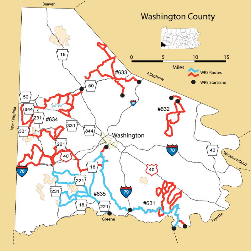
Details
Route#: 631
Route Name: SouthEast Washington
Compiler: Kathy Kern
Directions: Start at I 79 Interchange on TEN MILE ROAD and go toward Marianna (east) after village check on farm in bottom land on right
In Marianna, go to Horne's Cemetary and through ZOLLARSVILLE.
After crossing creek turn left and take next right LAUREL RIDGE ROAD (Midla farm)
At first fork take left. At T turn left. Make next right along CONRAIL old track.
Passes old PENN BOLT site. (STATION ROAD)
AT US 40 turn left and make next left (KINDER ROAD).
This comes out on STATION ROAD - make right and take next right.
At crossroads with SPRING VALLEY ROAD go straight across onto DOGWOOD ROAD.
Left on Daniels Run (south) to next left (SPRING VALLEY ROAD) to SCENERY HILL.
Turn right on US 40. Make third right at top of VAN VOORHIS HILL.
Bear right on GARRETT ROAD. Continue to BEALLSVILLE ROAD.
Turn left and go to STOP sign.
Make sharp right onto TURKEYFOOT ROAD. Take first right (BARNARDS ROAD).
At (old mill) BEALLSVILLE ROAD turn left. Take next left and make quick left again.
Continue to DEEMSTON. Turn right and take next right (HUFFMAN ROAD).
Turn left (BUCKINGHAM ROAD) and cross ridge road at top of hill. Make next left.
After schools, make left on DEEMSTON ROAD and continue until out of county.
Route#: 632
Route Name: Washington NE
Compiler: Gigi Gerben
Directions: Start point: Peterswood Park, Peters Twp. PA
Turn left on Froebe Rd.
Left on Sugar Camp
Right on Shawnee, turn around, retrace route towards Froebe, but continue straight, crossing Churchhill Rd.
Left on Trax Rd., observe from Trax parking lot, turn around, left on Trax, then left on Turkeyfoot Rd.
Left on Bebout Rd.
Right on Venetia Rd.
Left on Valleyview Rd.(can take short side-trip on Patterson, a right, turn around just past farmfields), pick up route again
Left on Sugar Run Rd.
Left on Meadowbrook
Right on Valleyview
Right on Hamton Rd.
Left on Sugar Run Rd.
Right on Venetia Rd.
Left on Churchhill Rd.
End route at Scenic Valley Golf Course.
Route#: 633
Route Name: Washington North
Compiler: Gigi Gerben
Directions: Begin at Canon Hill Farm on 980 North near Canonsburg, PA
Right turn on O'Hare Rd.
Left on Ciaffoni, multiple options for pulling over and observing along this road
Left on Vincenty
Right on 980
Left on 50
Right on Southview
Left on Primrose
Right on Baker
Cross Ft Cherry Rd (this becomes Walnut)
Turn right at T, park at open spot on left side of road at Reservoir
Turn around, head back to Walnut and make left, then left onto Ft Cherry Rd
Right on Noblestown
Left to follow Noblestown
Left on 980
Right on Donaldson Rd.
Right on North Branch
Left on Noblestown Rd.
Right on 980 North/S. McDonald St.
Left on Rte. 50
Right on Muse-Bishop Rd.
Left on McConnell Rd.
Right on Cecil-Henderson Rd.
Left on Morgan Rd.
Bear right following Morgan Rd. to National Cemetery
Left to National Cemetery of the Alleghenies
End route
Route#: 634
Route Name: Washington West
Compiler: Ryan Tomazin
Directions: No written directions submitted
Route#: 635
Route Name: SouthCentral
Compiler: Kathy Kern
Directions: Start in Clarksville at St. Thomas Church. Take Sandy Plains (Morey) road
Make left on Leonard Rd to left on Buckingham Road
Right on Huffman Rd to end.
Left on Morey Road and take next left on Hill Road
At stop go right onto Buckingham Rd
Left at Y onto Beallsville/Marianna road (Martindale Rd on map). Follow into Marianna
Stay right at Zollarsville intersection. In Marianna take left across bridge then right
onto Ten Mile Road - follow to rt. 19 and go right
Left on Hackney Station Road. Becomes Bane Town Rd. on map
Pass Mt. Herman Church / Dille Road - becomes Vista Valley Rd
Left on Alamae Lakes road then quick right onto Cove Road.
Left on Scenic Dr. around LAKE 4.
Left on Rt. 18 (south) and stay on until Rt. 221 in Prosperity
Turn right onto 221 North.
Left on Cracraft road. This flows into Sunset Road.
Left onto Valley View road.
Bear left onto Sawhill road
Left on Rte. 231 South
Left on Pleasant Grove back to 221.
Right onto Rte. 221 south to Craft Creek Road.
Right on Craft Creek and make right at top of hill onto Dunham Rd.
Left on Quaker Ridge briefly then right on Brick House Road.
Left on Willow Road and left on Templeton back to Rte. 231
Left on Rte. 231 to Rocky Road
Left on Rocky Road.
Straight at intersection onto Mt. Zion Road.
Follow back to Rte. 221.
Turn right onto 221 South.
Right on rte. 18 south.
Thru Prosperity and make left on Rte. 221 South.
At Greene County Line (sign) route is finished.