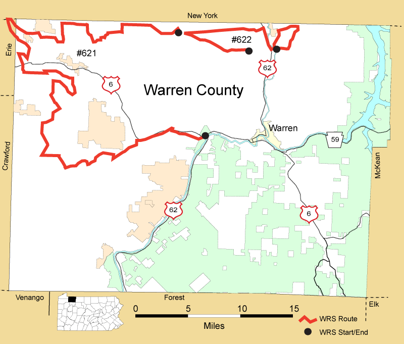
Details
Route#: 621
Route Name: NW Warren
Compiler: Scott Stoleson
Directions: Start in Sugar Grove Township at intersection of PA 957 and Sanders Road, going north
Turn left at intersection onto Dobson Road
Follow Dobson back to PA 957
Turn right onto PA 957 into Borough of Sugar Grove
Turn right (north) onto PA 69, then immediately left onto Catlin Hill Road
At first Y intersection take left onto North Road
Take left onto Forest Rd. and follow to its end at Stillwater Rd
Take right onto Stillwater and follow to its junction with Lottsville-Niobe Road
Turn left (south) onto Lottsville-Niobe Road, then take first right onto Valastiak Rd
Follow to end, turn right onto Rte 958, go north to junction with Greeley Street Extension, where take left onto Greeley St
At 1st Y, bear right onto Main Street in Bear Lake. This is called variously East Main St., Weeks Rd, and Grant Hill Rd (indecisive place, Bear Lake)
Continue westward on this schizoid road until it begins to veer northward into NY state; take left onto small gravel road called Reed Hill Rd. (stop and find resident Red-shoulder at swamp here)
Follow to its end and continue Southward on Pine Valley Road about 2/3 mile to Simmons Rd on right
Stay on Simmons through first Y (bearing right) to its end, then turn right onto Alder Bottom Rd, then take first left onto Hudson Rd
Hudson turns into Factory Rd after it crosses paved Scrambling Rd. At some random point in road it becomes Mill Rd (according to Google Map) follow to its end (checking Bald Eagle nest along creek) at Plank Rd. just below NY State line
Turn left on Plank Rd and follow to northern end of village of Columbus
Take right onto Muzzy Rd, follow Muzzy to T-intersection with Tillitson/Spencer Rd (another indecisive roadway)
Turn Left and proceed southward to US 6
Cross US 6 onto Scott Crossing Rd, continue about ¼ mile to first left (Baker Hill Rd)
Continue on Baker Hill to second left (Stony Lonesome Rd), take left then almost immediate right onto Carrier Rd
Keep going east on Carrier, which merges with and becomes Blue Eye Rd
Take right onto Old Rte 77 to intersection (again) with Blue eye Rd
Take Right onto Blue Eye
Turn Right onto Lindsey Rd
Cross Stroup Rd onto Baker Hill Rd
At 3-way intersection (all three labeled “Baker Hill” in Google Maps – inbred roads around here), turn due south (left) onto (surprise!) Baker Hill Rd
At PA 426 (Spring Creek-Corry Rd), turn left
Turn Right onto Old Rte 77
Turn Right onto PA 200
Take left onto Oil Creek Rd
Take left onto Tubbs Rd
Take left onto SR61009 (Mickle Hill Rd.)
Continue on Mickle Hill Rd to intersection with PA 27
Turn left on PA 27 and continue to village of Garland, at which turn right onto Old Garland Rd
Where Old Garland merges with Cole Hill, turn left onto continuation of Old Garland, and follow to its end at Dewey Hill Rd
Go North on Dewey Hill to intersection with PA 27, and turn left on PA 27 about 1/3 mile then veer right onto gravel Old Pittsfield Rd
Follow to US 6, turn right on US 6 to light at Railroad Street in Youngsville
Tturn right onto Railroad, then an immediate left onto Hillside Drive, which morphs into Rouse Avenue
Keep going east as Rouse merges with National Forge Road. Route ends where National Forge Rd intersects with PA 62.
Route#: 622
Route Name: North Warren
Compiler: John Fedak
Directions: Start at the intersection of PA 957 and Townline Rd.
Go west on PA 957
Go Right onto Old State Road
Go Right on Market St (PA 62)
Go Left on Aekley Rd
Go Right on Howard Road
Go Right on Norbert Road
Go Right on Cable Hollow Road
End at intersection of Aekley Road