Details
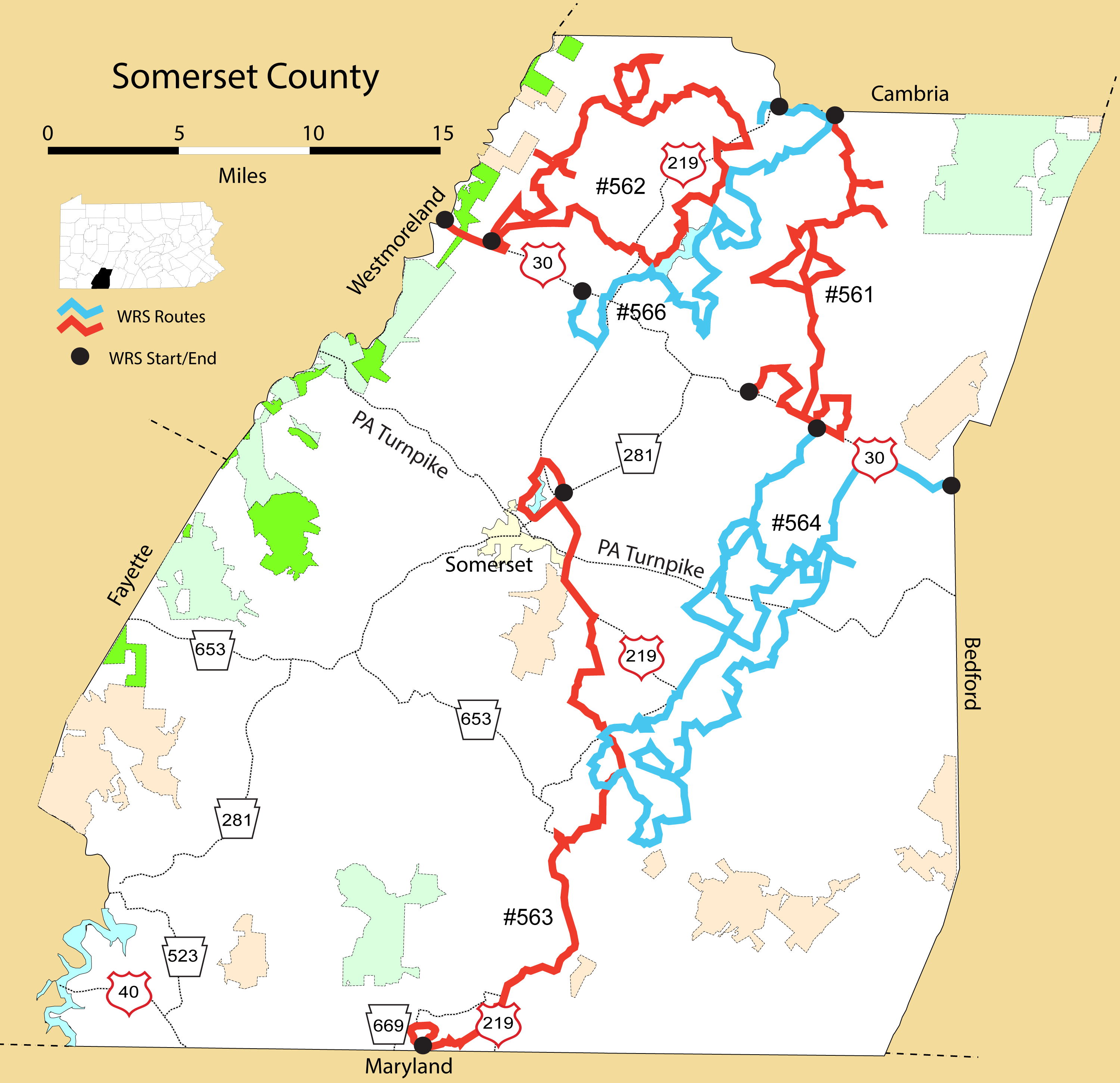
Route#: 561
Route Name: NE Somerset
Compiler: Tom Kuehl
Directions: Start at the Paint/PA 601 Exit from PA 56 in Windber (SE of Johnstown)
Go up the hill and bear left on Horn Road to Cairnbrook
Go straight across intersection onto PA 160 South
Left on Basin Road to take a look and then back to PA 160
Left down Morningland Drive for a look – turnaround at houses
Cross PA 160 onto Hillsboro Road
Left onto Berkey Road
Left (south) onto Ridge Road (SR 1025)
Right on Shade Street to go to Hooversville
In Hooversville take the 170 degree right onto Charles Street
Left to go north to repeat the route on Ridge Road
Right to repeat route on Hillsboro
Right onto Cider Press Road
Left to go east into a strip-mine area – Benny Road
Right to stay on Benny Road
Left on onto Ridge Road – SR 1025 to go south towards Buckstown
Right onto School Road – SR1021 to continue towards Rt. 30 – Buckstown
Left onto US 30 and go east
Left onto Boomer Miller Road
Right on T onto Hitchew Road
Right (south) onto Shade Church Road
Right to go west on US 30
Right at the Flight 93 Gamelands onto Johnson Bottom Road
Left onto SR 1010 – Old Forbes Road
Left onto Barta Road
End Route at US 30
Route#: 562
Route Name: NW Somerset
Compiler: Tom Kuehl
Directions: Start on US 30 on top of Laurel Ridge at the Westmoreland/Somerset County line
Left/North on Wilson Road
Left on Kline Mills Road SR4024
Bear right to stay on Klines Mill
Pull off to the right to check the strip habitat
Right on Blough Road – loop back to Klines Mill closed due to snow
Return to Klines Mill
Left (north) on Flat Run Road (SR 4047)
Right on Roaring Run/North Fork Dam Road
Right on Thomas Spory Road to US 985 (future to house and back)
US 985 turnaround
Right on Roaring Run/North Fork Dam Road
Left on Boy Scout Road to Walter E. Lohr Farm Barn and back
Spotted Red-shouldered Hawk on left
Roaring Run turns into North Fork Dam Road
Right on Saylor School Road
Left on County Club Road
Left on Hidden Valley Road
Right on SR #4029
Right to stay on Saylor School Road
Right on US 985, then immediate right on County Club Road
Left on Kaufman Hill Road
Left at Lost Valley/Swank Roads
Left on R. 985, then right on Kaefer Hill Road
Right on Weber Road
Cross to Miller Road – turns into Plender
Cross US 403 on Miller Picking Road
Right on East Campus Avenue
In Davisville turn left on US 403 South
Right on US 601
Left on Woodstown Highway
Left on Fallen Oak, which turns into Lemon Road
Turn right on Que Dam Road
Don't cross water – bear right on Pilltown Road
Left on Commonwealth SR 4037
Cross US 601 on Keyser Road
Left on Rolling Hill
Left on US 985
Right on Stemmler Road
Cross Pine Creek Camp Road – turns into Barnick Road
Left on Klines Mill Road
Right on Sliding Rock
End at US 30
Route#: 563
Route Name: S Somerset
Compiler: Linda Greble
Directions: Start at intersection of Geiger and Sechler Rd
Go N to Gilmour Rd
Turn Left on Gilmour to Wood Duck Rd
Turn Left on Wood Duck Rd to Lake Rd
Turn Left on Lake Rd to Stoystown Rd
Turn Left on Stoystown Rd to US 219 S entrance Ramp
Turn Right on US 219 S to Berlin Plank Rd
Turn Left on Berlin Plank Rd to Beachdale Rd
Turn Right on Beachdale to E Mud Pike Rd
Turn Right on E Mud Pike to Rocky Lane
Turn Left on Rocky Lane to Owl Hollow Rd
Turn Left on Owl Hollow Rd to Lichty Farm Rd
Turn Straight across into Lichty Farm Rd to Pine Hill Rd
Turn Slight right on Pine Hill Rd to Pony Farm Rd
Turn Left on Pony Farm Rd to Mason Dixon Hwy
Turn right onto Mason Dixon Highway, go .4 mi,
Turn right onto S 219 ramp , go 8.8 miles,
Turn right onto Old 219, at the south edge of the town of Salisbury, go .6 mile
Turn right on River Rd., go 4.1 miles,
Turn right on Springs Rd, go .3 miles,
Turn right on Shoemaker Hill Rd., go .7 miles,
Turn right on Niverton Rd., go 1.6 miles to intersection of River Rd,
which is the end of the route.
39 miles total route.
Route#: 564
Route Name: Somerset East-Central
Compiler: Tom Kuehl
Directions: Starting Point: Bedford County Line on Rt. 30
Proceed west on Rt. 30
Turn left onto Rt. 160 at Reels Corner
Turn left and loop Sugar Tree Road to Boone, turning right to return to Rt. 160. Note that during a scouting trip on 2/2/21 we found a Rough-legged Hawk
Go past Imgrund Mountain Road (Amish firewood)
Take the next left turn onto Suffer Run Road
Turn right on Bear Run Road to return to Rt. 160 – Huckleberry Highway Turn
Turn right to drive north on Rt. 160
This time take Imgrund Mountain Road – a right turn from Rt. 160
Take the first right onto Big Rock Road, as not able to continue to loop on Imgrund to Bluebird Lane, however travel further east into habitat on Imgrund Mountain Road and turn around to then turn left onto Big Rock.
Follow bends on Big Rock to return to Rt. 160
Turn left to drive south on Rt. 160 – cross the PA Turnpike (Downy)
Turn left onto Shipley Town Road
At T turn left onto Rt. 31 – Glades Pike
Turn at the first right onto Hickory Hollow Road, and follow two bends to the right to return to Rt. 160 – Huckleberry Highway
Turn left to drive south on Rt. 160
Turn left onto Slate Hill Road
Turn right onto White Horse Road
Turn left onto Macdonaldton Road
Follow 90 degree bend to the right on Macdonaldton Road
At T turn right onto Salco Road (note, getting a bit close to woodland habitat of the Allegheny Front, so no open habitat to the east or south to Salco)
At T turn left to drive west on Sugar Grove Road
Turn left to drive south on Rt. 160
Take the first right onto Glenmoris School Road (#653 on Google Maps) – No winter maintenance so turn around at farm at bend and return to Rt. 160
********** Revised on day after running the route, but would be good to confirm before the 2022 run to confirm all roads are open
Turn right onto Walker School Road
Turn right at T with Goodtown Road on the right
Follow the right then left bends to remain on Goodtown Road
At the Y/T turn left to drive south on Pine Hill Road
Turn at the first left onto Walker School Road
At Y bear left to stay to stay on Walker School Road
At Y/T bear right on Sawmill Road and continue east to Rt. 160
Turn right to drive south on Rt. 160
Take the second right onto Distillery Road (Note the first right is on Google Maps as #420 and per old Somerset County map may be Hays Mill Road), however may have access to it from Rt. 160)
At T if habitat good to the right (the just mentioned #420/Hays Mill Road) then investigate to the NE and then return
Turn left onto Bear Run Road
Drive south and then follow bends to the right to then drive west on Bear Run Road
At T turn right onto Maple Valley Road
Note Grange Road – short dead end on left as driving up hill
Just past Grange turn left at the top of the hill – on Google Maps it appears to be the Old Cumberland Pike, but not indicated with a road sign in 2021
Turn left onto Pine Hill Road
At Windy Hills Farm turn right onto Swampcreek Road
Follow a bend to the left and then turn right onto Crossroad School Road
At T turn left onto Lichty Farm Hill Road
At T with Rt. 219 turn right to drive north on the Mason Dixon Highway
Drive NE and past several connecting roads (including the no-maintenance in 2021 Buffalo Creek Road) to turn onto Pine Hill Road
***** End of issues with initial route planned for 2021
At the Y make a 135 degree turn to the left onto Weighleymill Road
At Y turn right onto the Mason Dixon Highway (Rt. 219) and drive into Berlin
Turn right at the Valero to drive east on Main Street
At the Firehouse Bakery turn left to drive north on Diamond Street
Continue north as Diamond Street becomes Beulah Road (RL Hawk and Harrier seen on scouting trip on 2/2/21)
Drive a long way north on Beulah to T with Rt. 31 – Glades Pike
Turn right onto Rt. 31
Turn left on Rt. 160
Take the first left on Roxbury
Turn left onto Shanksville Road (after going up and back on Pike View if good habitat)
Continue NW on Shanksville Road
Turn right onto Kimmel Road
Take Kimmel Road to Rt. 160 – Huckleberry Highway
Turn left onto Rt. 160, and then quickly turn left onto Stonybrook Road
Turn left onto Piney Run Road
Bear right at Y onto Kimmel Road
After a short drive bear right at Y onto Baltzer Bridge Road
***** Again initial 2021 route issues due to no-winter maintenance and/or could not find Yonai Road intersection with Shanksville Road so going north to Shanksville rather than south apparently missing Yonai Road
At T turn right onto Shanksville Road and drive north towards Shanksville
Bear right onto John Street to enter Shanksville
After a short distance turn left on Stutzmantown Road and drive west
Bear left at Y onto Weigle Road
At T turn right onto Sand Rock Road
Immediately turn left onto Reiman Road
Bear right at Y onto Brotherton Road
Turn left onto Willkow Road continue south on Willkow (if good habitat check out Yonai and turn around at or before reaching Peaceful Valley Road)
Go under the PA TP
At the Y bear left to drive southeast on Willkow and drive to Y with Swamp Hollow Road
If good habitat on Swamp Hollow then drive north on it, then return to drive south/southwest on Willkow Road to Rt. 31
Turn right to drive west Rt. 31 – Glades Pike (If the first right - Ringler Road has good habitat then check it out and return)
Turn right onto Brotherton Road
Cross the PA TP
***** More route designed on Google Maps, but shortened in 2021 to:
Continue north on Brothernton Road into Shanksville. Take Bridge Road north out of Shanksville, then bear right onto Buckstown Road to end route at Rt. 30 in Buckstown.
**** Likely to continue with route in future years as follows:
Go past Shady Hollow Road on the left to continue north on Brothernton Road
Bear left onto Coal Road
Turn left to drive south on Coleman Station Road
Take the first left onto Shady Hollow Road
At the T bear right onto Horse Track Road
Turn right onto Coleman Station Road
Drive north on Coleman Station Road and cross PA TP
Turn left onto Cambria Road
Follow several bends as Cambria continues north to end at the T with Stutzmantown Road and Sand Rock Road. Go straight to drive north on Stutzmantown Road
At Y bear left to drive first east then north on Sheep Ridge Road
Stay left at Y to continue northwest onto Sheep Ridge Road at Sawmill Run Road
Bear right at the double Y intersection to drive north on Sheep Ridge Road (#622) – do not go straight on Hunter School Road
Bear right at Y onto Welsh Hill Road
Turn right to drive south on Ross Road, although go a bit farther and turn around on Welsh Hill Road if excellent habitat
Drive south on Ross Road, go past T with Saw Mill Run Road and continue to T with Stutzmantown Road
Turn left onto Stutzmantown Road
At intersection turn left to drive north on Coleman Station Road
Go north past Welch Hill Road to turn right onto Green Brier Road
Bear left at Y onto Beagle Road
Bear right onto Coleman Station Road
Turn right onto Coleman Road
At T turn left onto Green Brier Road
At T turn left onto Pompey Hill Road
At intersection turn right onto Brownstown Hill
Turn right onto Fritz Road to return to Pompey Hill Road to drive east
At T turn left onto to go north on Lambertsville Road, then right onto Old Lincoln Road, then south on Cemetery Road
Turn left to drive south on Lambertsville into towards Shanksville
Turn left onto Buckstown Road and drive north to end at Duppstadt's Country Store on Rt. 30
Route#: 566
Route Name: East Quemahoning
Compiler: Linda Greble
Directions:
Start at intersection of Dickey Hill Rd and Carpenters Park Rd., Davidsville, PA.
Travel South on Carpenters Park Rd. to Walnut Hill Rd.
Slight right on Walnut Hill Rd., continue as it turns into Kaufman Ch. Rd.
Continue on Kaufman Ch Rd to end.
Left on Miller-Picking Rd.
Right on E Campus.
Left on Hickory St as you enter town of Davidsville, take Hickory St to end.
Left on 403, which is S Main St. at this point
Right on Woodstown Highway immediately after going under 219 overpass.
Continue on Woodstown Hwy until you meet Route 601, (Penn Ave) turn left.
Right on Abex Rd, take it to the end.
Left on Janidlo Rd.
Left on Naugle Rd.
Take Naugle Rd to dead end.
Turn around and backtrack on Naugle Rd to Janidlo Rd.
Left on Janidlo Rd, continue to crossroads of Koontz, Janidlo, and Uphouse Hill Rd.
Left on Koontz Rd.
Travel on Koontz Rd approx 1 mile, turn around before top of steep hill, backtrack on Koontz, continuing on Koontz all way to Plank Rd.
Left on Plank Rd.
Left on Hooversville Rd
Slight right onto Bassett Road to the end.
Left on Plank Rd into Stoystown.
Right on Somerset St.
Continue on Somerset St, crossing Main St, Somerset St soon becomes Bicycle Rd.
Continue on Bicycle Rd until Horner Ch Rd.
Right on Horner Ch Rd, to the end.
Right on Route 30. (Lincoln Hwy)
Left on Slagle Hill Rd.
Left on Green Bridge Rd, stop at Pilltown Rd.
End of Route.
Route length: 31 miles.
Route#: 567
Route Name: SW Somerset
Compiler: Sandy Cline
Directions: Starting at Laurel Hill State Park Visitor Center
Right out of parking lot and then left on Copper Kettle Hwy.
Right on Harvest Dr
Bear left on Shaff Rd
Right on Cassellman Rd.
Left on Turkeyfoot Trail Rd.
Right on Markleton School Rd.
Left on Rt. 281
Left on Colflesh Rd.
Right on Hogback Rd.
Right on 281
Bear left on Humbert Rd.
Left on 281
Left at Whipkey Dam Rd.
Left on Rt. 653
Right on Covered Bridge Rd.
Left on Ream Rd.
Left on Lyons Rd.
Right on Barron Church Rd.
Left on Copper Kettle Hwy.
Right into Laurel Hill State Park