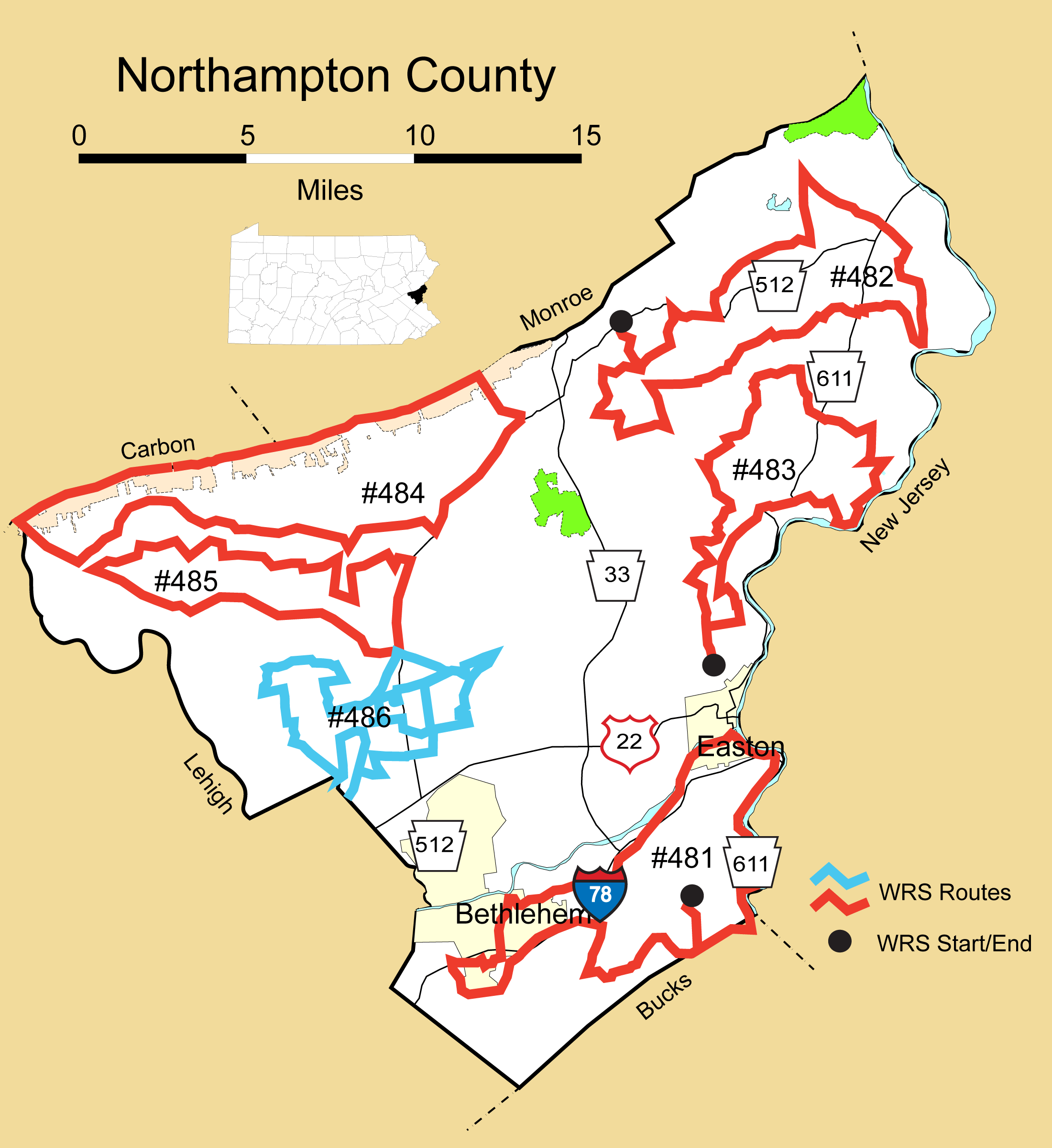
Details
Route#: 481
Route Name: South Northampton
Compiler: Arlene Koch
Directions: Start at 1375 RAUBSVILLE RD (west of Easton)
Left (west) onto Raubsville Road
Left at Durham Road
Left on County Line
Right at Sunnyside
Left at Hill Road
Left on PA 611 north, travel 611 all the way up to the Third Street bridge in Easton, go left under railroad overpass and take immediate right onto Canal Street, continue past Glendon Bridge to a right at Island Park Road (parallels the river)
Left at Lower Saucon Road
Right on Applebutter Road
Left on Shimersville
Left onto PA 412 into Hellertown
Go past I 78 and take a right at light with Crossroads Hotel on the left (don't know the road's name), cross creek, go right on Seidersville Rd (Lehigh's Stabler arena and ball fields here)
Left onto Mountain Drive
Left onto Friedensville
Left onto Main Street in Hellertown
Take immediate right slant onto Easton Road
Right onto Lower Saucon
Left onto Wassergass
Right onto Steely Hill
Left onto County Line
Left onto Durham Road
Right onto Coffeetown
Left at PA 611
Left at Royal Manor
Left at Ridge Road
Right at Kressman
Left at Raubsville back to my driveway.
Route#: 482
Route Name: NE Northampton
Compiler: Robin & Dan Zmoda
Directions: Start at Pen Argyl Rd and Main St in Pen Argyl.
south to Delabole Rd right, then right again on Grand central Rd, follow to end
left on Mack to end
right on Delabole to Church Rd and left
left on Knitters Mill to end
right, then right again on Heimer to end
left on Benders Church, follow to end
left on Pen Argyl Rd, then right on Mill Rd. Follow to end
left on PA 191 and bear right on Flicksville
at first intersection left, then first right on Springfield follow to end
right on Jacktown, then left on Bangor - Richmond Rd, crossing five points and progressing on Sunset.
left on Centerville Dr to end
left on PA 611 then right on Stone Church Rd
keep right as SC turns into Hartzells Ferry Rd, follow to end
left then left again on Shady Ln follow to end
right on Potomac and follow to PA 611
cross PA 611 onto Million Dollar Hwy and follow to Totts Gap Rd
left on Totts Gap and follow to Ridge Rd
right on Ridge and follow to end at Main St
left on Main to PA 512
right on PA 512 and follow to American Bangor Rd
left on American Bangor to Delabole Rd
right on Delabole to Pen Argyl Rd
right on Pen Argyl Rd and return to Main St starting spot.
Route#: 483
Route Name: East Northampton
Compiler: Robin & Dan Zmoda
Directions: Start at intersection of Meco and Richmond Rds
Go north on Richmond
Turn right on Newlins
Turn left on Broadway
Turn left on Frutchey Hill Rd
Turn right on Richmond, follow into Martins Creek and continue straight onto PA 611
Continue straight on Belvidere Rd (PA 611 bears hard left)
go out and back on Hillandale, De Haven and De Pues Ferry Rds
Turn right off De Pues Ferry, back onto Belvidere
Quick left on Richmond
Turn left on Miller
Continue straight across PA 611 onto Jacktown Rd
Turn left on Heinson Hill Rd and continue until Heinson turns into Brodt
Follow Brodt until it turns into Johnson Rd, which turns into Nagy Hill which turns into Labar Rd
Turn left then immediate right onto Mack Rd
Turn left on Franklin Hill
Turn right on Klauz
Turn left on Upper Mud Run
Turn right on Richard Garr
Turn left on Klein
Turn left on Ayers to end
Turn right on Uhler
Turn left on Glover to end
Turn right on Richmond and follow back to Meco at end of route
Route#: 484
Route Name: NNW Northampton
Compiler: Rick Gaeta
Directions: No directions submitted, but here is a description of the area.
West Boundary PA 248
South Boundary PA 946
East Boundary PA 512
North boundary Blue Mountain - Appalachian Trail
Route#: 485
Route Name: WNW Northampton
Compiler: Rick Gaeta
Directions: No directions submitted, but here is a description of the area.
West Boundary Intersection of PA 946 and PA 248
South Boundary PA 248
East Boundary PA 512
North Boundary PA 946
******************************************************************************
Route#: 486
Route Name: West Central Northampton
Compiler: Todd A. Watkins
Directions: 1. Start at Old Airport Rd @ Weaversville Rd, N to First Responders Park
2. L into First Responders Park, loop, R on exit
3. R on First Responders Dr to Airport Rd
4. R on Airport Rd to Snowdrift Rd
5. L on Snowdrift Rd to fork w/Colony Dr
6. At fork stay R on Snowdrift Rd to Dogwood Rd
7. L on Dogwood Rd to Hanover St
8. L on Hanover St to Bicentennial Park
9. L on Liberto Ln into Bicentennial Park, loop, R on exit to Weaversville Rd
10. R on Weaversville Rd to Walnut St
11. R on Walnut St to N Bath Blvd (329)
12. L on 329 to New Seemsville Rd
13. R on New Seemsville Rd to Mud Ln
14. L on Mud Ln to School Rd
15. R on School Rd to Old Carriage Rd
16. R on Old Carriage Rd to Snyders Church Rd
17. R on Snyders Church Rd to Cricket Rd
18. R on Cricket Rd to Green Meadow Rd
19. R on Green Meadow Rd to Driftwood Rd
20. L on Driftwood Rd.to Nor Bath Blvd (329)
21. L on Nor Bath Blvd (329) to Jacksonville Rd fork; check RCN towers
22. Stay L on 329/987 at Jacksonville Rd fork, to Mill St.
23. R on Mill St to Horner St
24. R on Horner St to Allen St
25. L on Allen St & stay to R around Wolf School to Keim St
26. R on Keim St to Broad St
27. L on Broad St to E Main St
28. R on E Main St/Newburg Rd to Silver Crest Rd
29. R on Silver Crest Rd to 512
30. L on 512 to School Rd
31. R on School Rd to Jacksonville Rd
32 L on Jacksonville Rd to Arrowhead Ln
33. L on Arrowhead Ln to Locust Rd; check W. Locust Dr
34. L on Arrowhead Ln to Jacksonville Rd
35. R on 512 to Regency Blvd
36. R on Regency Blvd to Steuben Rd
37. R on Steuben Rd to Township Line Rd
38. L on Township Line Rd to Nathaniel Dr
39. R on Nathaniel Dr to Silver Crest Rd
40. L on Silver Crest Rd to Newburg Rd
41. R on Newberg Rd to Gun Club Rd
42. L on Gun Club Rd to Blossom Hill Rd
43. R on Blossom Hill Rd to Georgetown Rd
44. R on Georgetown Rd to Dogwood Ln
45. R on Dogwood Ln to Oakland Ln
46. R on Oakland Ln to Georgetown Rd
47. R on Georgetown Rd to Surrey Park
48. L into Surrey Park, loop, R on exit to Steuben Rd; check Dutch Springs towers
49. L on Steuben Rd to Township Line Rd
50. L on Township Line Rd to Jaindl Blvd
51. R on Jaindl Blvd to 512
52. L on 512 to Hanoverville Rd
53. R on Hanoverville Rd to Monocacy Park
54. R into Monocacy Park, loop, R on exit to Jacksonville Rd
55. L on Jacksonville Rd to Orchard Ln
56. R on Orchard Ln to Airport Rd
57. End at Airport Rd
******************************************************************************