Details
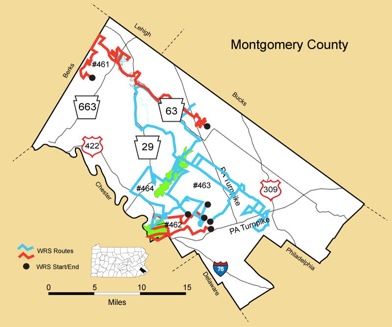
Route#: 461
Route Name: North Montgomery
Compiler: August Mirabella
Directions: Start at the intersection of Wambold Rd. & Allentown Rd. and continue on Wambold and go RIGHT on Schoolhouse Rd. (We go on industrial driveways off Schoolhouse Rd. to get better views-Asher's Chocolate-redtail nest on left, former Heavener, Hagey's, etc).
RIGHT on Nice Rd. to welding company and reverse back to Schoolhouse.
Then RIGHT on Souder Rd. Go into rendering plant to get better view(Due to COVID19 barricades and no trespassing signs prevented this in 2021). Reverse back to Schoolhouse.
Go LEFT on Skippack Creek Rd. (OPTIONAL) and reverse back to Roberts Rd. & go LEFT.
Go LEFT on Cassell Rd. and reverse at the turnpike and go back Cassell to Schoolhouse Rd.
Go RIGHT & then go LEFT on Foreman Rd. Go RIGHT on Hagey Rd. (industrial park road) and back to Foreman.
Cross Foreman & go on the new section of Hagey Rd. and reverse.
Continue and turn LEFT on Lower Rd.
Continue to new Souderton High School (go into school road as far as the bend and reverse back to Lower Rd.) and backtrack to Schoolhouse Rd. on Lower & Foreman.
Go RIGHT on Schoolhouse & cross PA 113(Harleysville Pike) and make a RIGHT on Indian Creek Rd.
Continue to Clemmens Rd and go LEFT and then LEFT on Hunsicker Rd.
Then RIGHT on Fell Rd.
At Morwood go left to double dogleg. Stop at 2nd dogleg and scan.
Reverse on Morwood to Ruth Rd. on LEFT.
LEFT on Ruth Rd. to RIGHT on Long Mill Rd.
Go to Sumneytown Pike (Bald Eagle nest along creek 2017). Due to bridge closure, route change here Go RIGHT on Sumneytown Pike and then RIGHT on Thompson Rd,
RIGHT on Moyer Rd. and go LEFT on Cressman Rd. (This change may be reversed in 2022 as bridge is now being rebuilt & can take Moyer Rd directly to Cressman Rd).
Go Right at first road which is Morwood Rd (?) per map but road sign says Camp Rd. and check preserved farm then reverse back past Cressman on Morwood (?)/Camp Rd..
Continue to small development on LEFT, which is Farview Drive (dead end). This has a good view.
Now go back and go LEFT and then LEFT on PA 563 (Ridge Rd.).
Continue on PA 563 to PA63 (Sumneytown Pike) and go RIGHT and then RIGHT on PA 29. If needed stop at the rest rooms at the mini-mart at this intersection.
Continue on PA 29 and go RIGHT on McLeans Sta. Rd all the way into golf course stopping where the road doglegs near a big house & driveway.
Reverse at end of road and turn RIGHT on Buck Rd. to LEFT on Campbell Rd.
Turn RIGHT on PA 29 and check the first field on the right near Walters Rd. on left.
Now reverse on PA 29 and then RIGHT on Knight Rd.
Continue to PA 663.
TURN RIGHT ON PA663 AND BARE RIGHT ON OAK RD. TO MONTGOMERY AVE.
TURN RIGHT ON MONTGOMERY AVE. AND GO TO WALT RD. AND TURN RIGHT.
Continue to the park entrance AND DRIVE THE PARK ROADS. Bathroom
stop if needed.
Reverse back to Montgomery Ave. and turn LEFT into Mensch Dam Rd.to the sewer plant and reverse back to Montgomery Ave.
Cross back over PA663 to Schoolhouse Rd. AND TURN LEFT ON LANDIS RD. AND GO TO CHURCH RD.
TURN LEFT ON CHURCH RD AND THEN RIGHT ON BUCK RD., LEFT ON MACK RD., AND LEFT ON HOCK RD. TO CHURCH RD. CROSS OVER INTO CHURCH RD. BIRD SANCTUARY LOT TO SCAN AREA (GOOD SPOT TO EAT LUNCH). ROUTE CHANGE HERE:
Leave Bird Sanctuary going LEFT on Church Rd. TO KUTZTOWN RD.
GO RIGHT TO FRUITVILLE RD, GO RIGHT TO CLOSED BRIDGE & REVERSE. THEN RIGHT ON KUTZTOWN RD. TO BETHESDA CHURCH RD. AND TURN RIGHT. THEN TURN LEFT ON ADAMS RD. AND THEN LEFT ON COUNTY LINE RD.
GO LEFT AT KUTZTOWN TO GET BETTER VIEW OF LEFT SIDE OF ROAD (OPTIONAL) BUT TURN AROUND AT BETHESDA CHURCH RD. AND GO BACK TO COUNTY LINE AND GO LEFT. County Line Rd. may now be called Schwenkenfelder Rd.
Then go LEFT on Gehnman Rd. Then RIGHT on Miller Rd. (sign says Wentlings School House Rd on the left).
Then continue on Miller to LEFT on Niantic Rd. and immediately RIGHT on Miller Rd.
CONTINUE TO MOSER RD. AND GO LEFT TO CONGO-NIATIC RD. AND TURN AROUND BACK TO MILLER RD.
GO LEFT on Miller Rd. Continue to LEFT on Hoffmansville Rd. Shortly there is a long old chicken house converted to businesses. You drive to the back of it to get better look at fields. Then back to Hoffmansville Rd and go LEFT.
Then LEFT on Congo-Niantic Rd. and then RIGHT on Hoffman Rd.
END ROUTE at intersection with Green Hill Rd.
Route#: 462
Route Name: Valley Forge
Compiler: Barbara Hiebsch
Directions: Start at the Elmwood Park Zoo & Park area in Norristown
Go west on Sterigere Street, past a part of the Norristown State Hosp. and the Norristown Farm Park
Go left on Whitehall Road to Schuylkill Avenue in Jeffersonville, passing by the Westover Country Club to the Schuylkill River where a hike and bike trail overlooks it from a parking lot
Go right on Port Indian Road passing the opposite side of the golf course.
Go left on Egypt Road to Trooper Road to the Betzwood Bridge area.
This Schuylkill River area also included the" Lofts"(condos).
Go south US 422 to Valley Forge State Park
Drive all of the roads in the park staying on the Montgomery Co. edge with Phoenixville.
Also Quarry Road on the edge of the park.
Take Valley Forge Road to Beidler Road, passing thru Abrams by the Norfolk/Southern Railroad.
Go left on PA 23 East, to US 202 N.
Stop at the parking lot at the Bridgeport Dam.
Continuing on US 202 to Lafayette Street in Norristown to Ford Street.
Route#: 463
Route Name: Central Montgomery
Compiler: Barbara Hiebsch
Directions: Start in Norristown on Old Arch Road
Turn notheast on Old Arch Road
Turn left on Jolly, passing the Mermaid Lake & Golf Club
Turn right on Wentz Road
Turn right on Skippack Pike (PA 73)
Turn left on Cathcart Road passing the Montco-community college.
Turn right on Township Line Road
Turn right on Plymouth Road
Turn left on Morris Road by Upper Dublin.
Turn right on Sheaff Lane
Turn left on PA 73
Turn right on Militia Hill Road and go into Fort Washington State Park. (Drive all roads thru park).
Exit on the Joshua Road side. (Check out the Quarry there - a known vulture roost)
Turn left on Stenton Road
Turn left on Cricket Road
Turn straight on Valley Green Road
Turn left on Bethlehem Pike
Turn left on Lafayette Avenue
Turn right on Skippack Pike
Turn left Butler Pike
Turn right on Norristown Road
Turn right on Narcissa Road past Wings Field then the parking lot at Prophecy Creek
Turn left on PA 73
Turn left on Butler Pike
Turn left on Morris Road
Turn left on Wentz-church Road then backtrack to Morris Road
Turn left on Morris Road
Turn left on Bustard Road
Turn right on PA 73
Turn right on Forty Foot Road
Turn left on PA 63
Turn right on PA 113 to Franconia
Backtrack to PA 63 and go right
Turn left on PA 29 to Zeiglersville.
Turn through Spring Mount over to PA 113 and go right
Turn right on PA 113
Turn left on PA 73 and backtrack to starting point.
Route#: 464
Route Name: Evansburg
Compiler: Barbara Hiebsch
Directions: Start at Germantown Pike @ the Norristown Farm park entrance
Drive the single long Road that goes through the heart of the park
Exited on the Sterigere Street side of the Norristown State Hospital (only 1 Road @ Hospital)
Turn left on Sterigere Street
Turn right on Buttonwood Street
Turn right Main Street
Turn left on South Montgomery Avenue which leads into the Riverside Cemetery.(drove throughout cemetery)
Turn back out South Montgomery Avenue, cross Main Street
Turn left on Marshall Street
Turn right on Whitehall Road covering a part previous not done.
From Whitehall, I made a left following Germantown Pike
Turn left on Park Avenue
Turn left into a condo area (good overlook) on Clark Hill Road and parked at the intersection with Archer Court
Continued back with a left on Park Avenue (crossing Ridge Pike)
Turn left on Crawford Road
Turn right on Egypt Road past the George Washington Golf course
Turn left on Pawlings Road
Turn right into the parking lot of Mill Grove (Audubon) Park
Exit by a right on Pawlings Road a short distance to St. Gabriels Hall parking lot (this area is filled with fields)
Turn left on Pawlings Road
Turn right on Lyan Road to Egypt Road, parking along the couple entrances for the Lower Perkiomenville Park (New Mill Road is the main entrance.)
Continue straight across the road on Cider Mill Road (this gives you a look at both sides along the Schuylkill River under
the US 422 bypass. Didn't go on it.)
This drops into Arcola Road (at the split ) continue on the left side. (not over the bridge)
A good spot for lunch as there is a Wegmans here surrounded by fields.
Continue to the left where Arcola becomes Mennonite Road
Turn right on Trappe Road (PA 113)
Turn right on PA 29 south
Turn left on Main Street
Briefly pull into the old Collegeville Inn (closed Restaurant) overlooking the Perkiomenville Creek
Cross the road at the split that goes towards Germantown Pike
Immediately go left on River Road (again following creek.)
Turn right on Township Line Road
Turn left on Evansburg Road
Turn right on Wayland Road (this area had a rough-legged hawk last winter)
Turn left on Skippack Creek Road
Enter the Evansburg State Park. I drove through all of the roads, including one that led to hunting area.
Turn right on Evansburg Road
Turn left on Hallman Avenue
Reversed back to Evansburg onto Kratz Road to Anders, to Stump Hall Road ( this area in Worcester gives a great overlook over all open fields)
To Green Hill Road past Worcester Golf Course.
Reverse Road till Green Hill becomes Grange Avenue N
Turn right on Ridge Pike a short distance
Turn left on Fern Ave parking here
Turn right on Ridge Pike (heading back) to the Jeffersonville Golf course, ending route at Schuylkill Ave S and Main Street (ridge pike).