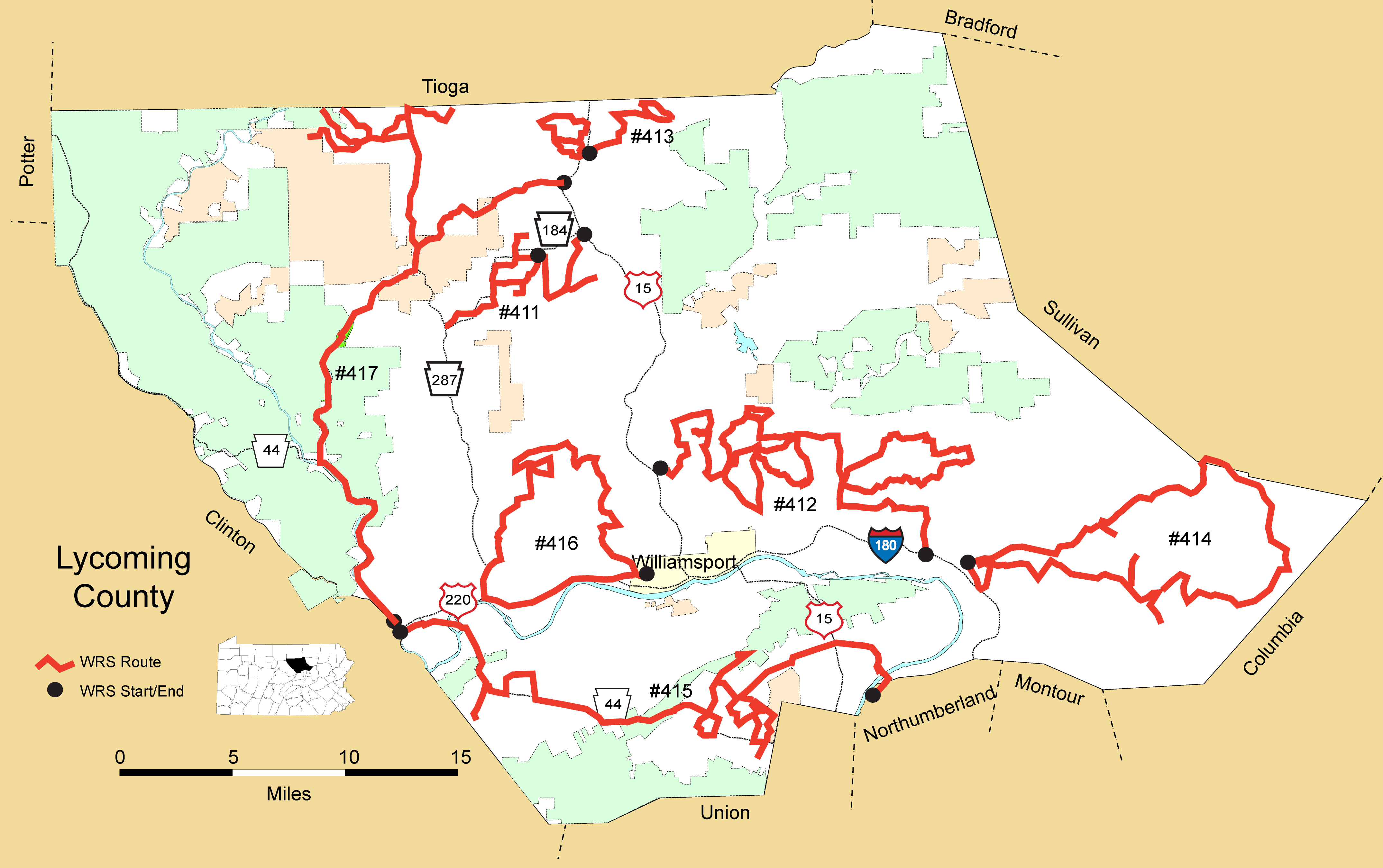
Details
Route#: 411
Route Name: Cogan House Twp
Compiler: Dave Ferry
Directions: Start off the new Cogan House Exit off of US 15
Take Steam Valley Rd to PA 184
Turn left on Cogan House Rd to Green Mountain Rd (just go up a mile to big fields and turn around)
Back to Cogan House Rd
Turn right on Cemetery Rd
Turn left on PA 184.
Turn left on Taylor Rd to Caldwell Rd
Turn Left on Blair Rd
Turn right on Stryker to top of hill
Turn around and back to Blair and Caldwell
Go left back on Caldwell to left on PA 184
Take PA 184 West all the way through White Pine
Turn right on Frenchtown Rd to PA 287
Retrace route back to PA 184 and pickup route again on PA 184 at Caldwell Rd and follow PA 184 (Left on Post Rd) continue on PA 184 and end route at Taylor Rd
Route#: 412
Route Name: Lycoming Central
Compiler: David Rothrock
Directions: Start: Hepburnville
973 East
SR 2020 (Elkard Road) North
Beach Road North
Pleasant Hill Road East
SR 1001 (Rose Valley Road) South
Spook Hollow Road West to dead end
Return to SR 1001- continue South on SR 1001 (Rose Valley Road)
973 West
SR 2023 South
SR 2024 East
Smokey Corners Road North
Bruchlacher Road Northeast
Pleasant Valley Road East
SR 2029 (Northway Road) South
Ridge Top Road to Bruchlacher Road
Return to SR 2029 (Northway Road) – continue South on SR 2029 (Northway Road)
973 East
Bush Hill Road Southwest
Lick Run Road West
SR 2029 (Northway Road) North
Quaker Hill Road West
Smokey Corner Road South
SR 2024 South
SR 2029 (Northway Road) North
Harvey Road South (becomes Winner Road)
Loudenslager Road East
SR 2031 (Lick Run Road) East
SR 2039 (Warrensville Road) North
973 East
87 South
Careys Hill Road Northeast
SR 2041 North
SR 2030 (Reeder Road) East
SR 2032 (Kehrer Hill Road) Northeast
864 West
87 South
SR 2028 East
Mall Road South
Stop: @ I-180 (220)
Route#: 413
Route Name: Jackson Twp
Compiler: Dave Ferry
Directions: Start at Covered Bridge Rd and Knipe Rd
Covered Bridge Rd to Laurel Hill Rd
Left on Williamson Trail Rd
LEFT on Mountain Run Rd
RIGHT on Mountain School Rd /Williamson Trail Rd
RIGHT on Marshall Rd
LEFT on Roaring Branch Rd
RIGHT on Forman Hollow Rd
and Kehler School Rd
turn around and back to Roaring Branch Rd
LEFT on Cross Rd
END back at intersection with Marshall Rd
Second leg:
Begin route at intersection of Knipe Rd. and Brion Rd....travel NE going counter clockwise....Rt onto Loundenslager...go about 1/4 mile and return to Brion. Rt. onto Route Rd. Left on Milk Plant Rd. Left on Artley to Raker to Zeafla Hill Rd. to Lt. on Blacks Creek Rd. continue on Black Creek to Left on Bower back to left on Raker. Left on Brion return to start.
Route#: 414
Route Name: SE Lycoming
Compiler: Evan Houston
Directions: From US 220 N in Pennsdale, turn right on Middle Rd, follow to stop sign
Left on East Lime Bluff Rd, go .2 mile
Left onto Beacon Light Rd, go 1 mile
Left onto Narber Fry Rd, follow to stop sign on US 220
Right on US 220 N
Right on Beacon Light Rd
Left on Ellis Artley Rd
Right on Lime Bluff Rd
Left on PA 405 N to second light in Hughesville
Right on PA 118 E. follow this road into Moreland Twp
Right on Stoney Batter Rd; go .5 mile, turning around and returning to PA 118 E
before coming into Lairdsville, turn right on Dairy farm Rd, to Tome Rd, then turn around and return back to PA 118 E
In Lairdsville, turn right on Funston Rd, folowing to stop sign
Left on Moreland Baptist Rd
Right on Salem Schoolhouse Rd
Left on PA 42 N to intersection of PA 118
Go straight through on PA 42 N to stop sign at PA 239
Left on PA 42 N, into Sullivan Co (not on our route) SR10 marker; returning back to our route on Beaver Lake Rd, at the Lake; stay on Beaver Lake Rd , to Frantz Rd, turning left.
Go 1 mile, turn around and return back to Beaver Lake Rd.
Follow into Hughesville.
Get back onto US 220 S to Pennsdale, finishing route.
Route#: 415
Route Name: SW Lycoming
Compiler: Joe Yoder
Directions: Start on PA 44 at the western boundary of Lycoming-Clinton counties
Take PA 44 south to PA 880
Take PA 880 south to Davidson Road and then backtrack to PA 44
Continue on PA 44 South to Coldwatertown Road
Left onto Coldwater Town Road
Coldwater Town Road to Pearson Road
Right on Pearson and return to PA 44
Continue on PA 44 South to Elimsport
Right onto Gap Road
Right onto Leisure Acres Road
Right onto Ireland Road
Continue straight onto Bower Road
Left onto Sulphur Springs Road and proceed to the top of North White Deer Ridge
Turn around and go back down Sulphur Springs Road
Left onto Spring Creek Road
Left onto Elimsport Road
Left onto Bud Drick Road
Left onto Pikes Peak Road (SR 2003)
Right onto Cooley Road
Left onto PA 44
Left onto Bob Drick Road
Turn around at the bridge and return to PA 44
Left onto Mill Road and proceed to Alvira Road
Left onto Alvira Road
Left onto Gibson Road, which loops to Pikes Peak Road and back to Alvira Road
Left onto Alvira Road and proceed to Elimsport Road
Right onto Elimsport Road
Take Elimsport Road to Us 15 and continue straight (the road is now known as PA 54)
Continue on PA 54 through Montgomery, taking the bridge over the Susquehanna River
Right onto River Road
End at Fogelman's Road
Route#: 416
Route Name: West-Central Lycoming
Compiler: Joe Yoder
Directions: Start on West Fourth Street, Williamsport, near Williamsport Area High School.
Right on Dougerty's Run Road
Left on Bottle Run Road
Left on Bower Road
Left on Almost Country Road
Right on Maple Spring Road
Left on Beauty Road
Right on Grove Road
Left on Mill Hill Road
Roght on Dougherty's Run Road
Right on Paulhamus Road
Left on PA 973
Right on Windy Ridge Road
Left on Bruce Road
Right on Quenshukeny Road
Left on Chestnut Ridge Road
Stay straight onto Picnic Woods Road
Becomes Pine Run Road
Seely Run Road
Right on Devil's Elbow Road
Left at Larryville Road
Left to PA 287 South
Proceed south to US 220 North
Turn left to US 220
End at West Fourth Street exit of US 220, Williamsport.
Route#: 417
Route Name: West Lycoming
Compiler: David Rothrock
Directions: Start at US 15 and Knipe Rd
West on Knipe Rd
Right on Brion Rd.(before going right on Brion go left for about 1 mile and turn around)
Right on Bower Rd
Straight on Zeafla Hill Rd
Left on Blacks Hill Rd
Right on Raker Rd
Right on Ten Point Rd.