Details
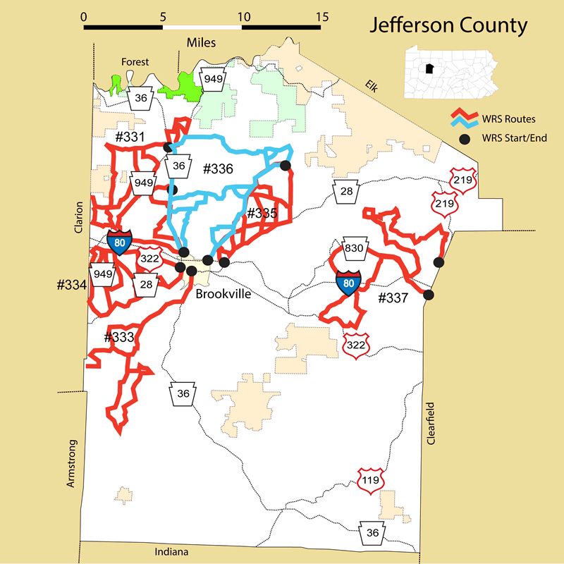
Route#: 331
Route Name: NW Jefferson
Compiler: Pat Conway
Directions: Starting at Sigel go East on PA 949.
Left on Miller Rd.
Right on Shaffer Rd.
Left on 949 to Shaffer Rd.
Right on Wolford Rd.
Left on Beers Rd and back to Fisher Rd.
Fisher Rd to Sharp Road.
Right on Sharp Road.
Left on PA 36 to Iron Bridge Rd.
Left on Fisher Rd.
Right on McCutchen Rd.
Right on Snyder Rd.
Left on Aaron Rd.
Aaron back to Wishart Rd.
Left to Clinger Rd.
Left on Howe Rd.
Right to Snyder Rd.
Right to Blair Road
Right to O'Donnel Rd.
back to Fisher Rd.
Catholic Church Rd. to PA 949.
Right on PA 949 to George Rd.
Left on George Rd.
Left on Winters Rd.
Left on Maplevale Rd.
Left on PA 36 N towards Sigel.
Left on Turner Rd
Right on Dug Hill Rd.
Right on Ferguson Rd.
to PA 36 N.
Left onto McManigle Rd.
Right to Park Rd.
Back to PA 36 N.
Route#: 333
Route Name: Ohl Area
Compiler: Pat Conway
Directions: Starting at Brookville take PA 36 South to Sheep Farm Road
Right onto Sheep Farm Road
Follow Sheep Farm Road South onto Mt. Pleasant Rd, Weaver Rd, Pansey Hollow Rd, Trayer Rd, Copenhaver, Bodorf, Heathville, Smith Rd, Cunningham, Heathville-Ohl Rd. and back up around to Roller Coaster Rd.
This area entails Worthville, Pansy, Langville, Heathville, Ohl, Summerville and Coder Station in Rose Township.
Route#: 334
Route Name: Corsica Area
Compiler: Pat Conway
Directions: No directions submitted, but here is an outline of the area covered.
Starting at Brookville take US 322 East to Corsica
Starting at Brookville take PA 28 S towards Summerville
This area entails everything in between these two roads.
It makes a triangle bordering the Clarion County Line on the West.
Route#: 335
Route Name: North Central Jefferson
Compiler: Pat Conway
Directions: Starting NE of Brookville just past the I 80 bridge on PA 28, turn left onto Davis Road.
Crisscross back roads between PA 968 (Richardsville Rd.) and PA 28 (Road to Hazen/Brockway).
Roads to include: Butler Cemetary Rd., Uplinger Rd., Milliron Rd., Gravel Rd., Greenawalt Rd., Kings Rd., Mays Rd., Brocious Rd., Richardsville Rd., Shaffer Rd., to Hump Back Rd. (Hump Back Rd. is not maintained in the winter.)
This area forms a triangle beginning at the I 80 bridge North of Brookville and ending at Hump Back Road east of Richardsville.
Route#: 336
Route Name: Brookville
Compiler: Pat Conway
Directions: Start at Huhey Road, just off of PA 36 in Brookville, PA (Near the Brookville Area High School)
The west border of this route is PA 36 North from Brookville, PA to PA 949 North past Sigel, PA, Spring Creek Road.
The East border of this route is PA 968 North from Brookville, PA to Dixon Road past Richardsville, PA.
The roads traveled include:
Hughey Rd.
Mineweaser Rd.
Stone Rd.
Greeley Rd.
Moore Bridge Rd.
Barber Rd.
Richardsville Rd.
Burcher Rd.
Dixon Rd.
Chamberlin Rd.
End at Ace Hardware, in Brookville, PA at the intersection of US 322 and PA 968 North
Route#: 337
Route Name: ENE Jefferson
Compiler: Dan Richards
Directions: Start at the intersection of Old Grade Road and US 219 north of Falls Creek
Old Grade Road to Harvey's Run Road; turn right
Harvey's Run Road to Woods Road; turn left
Woods Road to Wilson Road; turn left
Wilson Road to Beechtree Road; turn right
Beechtree Road to Beechwood Road; turn left
Beechwood Road to Ridge Road; turn left
Ridge Road to Patton Road; turn right
Patton Road to Westville Road; turn left
Westville Road to Beechton Road; turn right
Beechton Road to Woodbury road; turn left
Woodbury Road to Coal Glen Road; continue straight ahead
Coal Glen Road to Bushley Road; turn right
Bushley Road to Cyphert Road; turn left
Cyphert Road to Sugar Hill Road; turn left
Sugar Hill Road to Coal Glen Road; turn left
Coal Glen Road to Ridge Road; turn right
Ridge Road to Stevenson Hill Road; turn right
Stevenson Hill Road to Beechwood Road; turn left
Beechwood Road to Beechtree Road; turn right
Beechtree Road to Airport Road (SR 830); turn right
Airport Road to Stevenson Hill Road; turn left
Stevenson Hill Road to Hormtown Road; turn right
Hormtown Road to US 322; turn left (Hormtown Road is both TR 1003 and 3042)
US 322 (east) to Vo Tech Road; turn left
Vo Tech Road (T575) to SR 950; turn left
SR 950 to Sandy Valley Road; turn left
Sandy Valley Road to Pardus Road; bear right
Pardus Road to Sensor Road to SR 830 (Airport Road); continue straight ahead and follow SR 830 to Clearfield County line in Falls Creek