Details
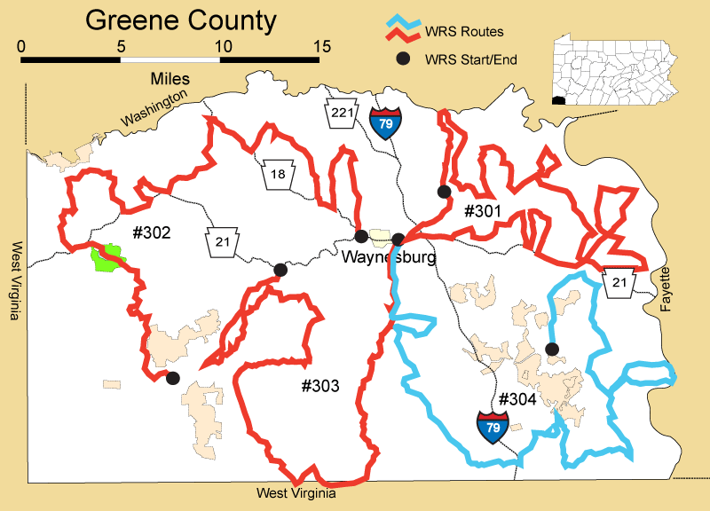
Route#: 301
Route Name: NE Greene
Compiler: Kathy Kern
Directions: START: From 322 Kennel Road turn left out of driveway onto Kennel road.
Proceed thru covered bridge and cross route 221 onto Woodies Road.
Continue onto Piper RIDGE (becomes Castile RIDGE Road) turn right onto Castile RUN Road.
Make right turn onto Meadowbrook Road.
Left onto St. Rt. 221 (Lippenncott Road).
Left onto Country Club Road (Twp Rte 585).
Returns to Jefferson Road (SR. 188) - make left (east).
Make next left onto Brown's Run Road, then take second right onto Pyle Road.
Continue straight through first "Y". Bear right at second "Y" onto Piper Ridge Road.
Make right onto Center School Road.
Bear right on Clarksville Road. Proceed into Jefferson and turn left onto Route 188 (east).
Follow Rt. 188 and make first left onto Goslin Road.
Turn left onto St. Rt. 88 (north).
Make first left onto Clarksville Road.
Make first left onto Adamik Road.
Return to Goslin Road and turn right (west).
Make left on SR. 188 (east) and follow to second right onto Shortcut Road.
Make right onto SR. 88 (south- toward Carmichaels).
Just before entering Carmichaels, turn right onto Green Valley road which sort of makes a left but on the map continues as Green Valley Road (SR 1019).
Follow Green Valley (makes a sharp left) to SR 21 East - Roy Furman Highway.
Make left onto route 21 toward Paisley. Turn left onto Glades Run Road.
At STOP turn right on route 88. At Rutter's Lane make left. SR 1027.
Follow straight thru intersection onto Wahula (on map Walter Drive then Wahula).
Left on Nemacolin Rd.
Right on Thomas. At STOP sign turn left onto Browns Ferry Road into Carmichaels.
At STOP make right onto Market St. Follow North Market St. through the town square.
Make right onto Hill Road. At top of hill turn right on Hathaway.
Right on Air Shaft Road (at STOP sign cross Crucible road and continue on Air Shaft road).
Right on Jacob's Ferry road. At STOP turn right on Crucible Road and back into Carmichaels.
Follow West George St. thru square. Straight at stoplight and continue on East George St.
At next stoplight turn right onto rte. 21 west.
Right onto Kovalchecks Road.
Make left at Reynolds Drive and then left on Bruckner Road (west).
At STOP continue Left onto Haver's Hill (south).
Turn right on route 21 west to Eaton Run (next right).
Turn left onto Ridge Road.
Follow to McNeely road and turn right.
Make next left on Bedilion Road.
Right on Route 21 west and follow into Waynesburg. At Sheetz stop light make right on Route 188 – Jefferson Road . In 3 miles make left onto Kennel Road.
Route#: 302
Route Name: NW Greene
Compiler: Marjorie Howard
Directions: Begin at intersection of PA 18 North & PA 21 West
Right on Water Dam Rd. (SR4035)
Left on Garner Run (SR4033)
Right on Browns Creek Rd. (PA 18)
Right on WWRailroad Rd (SR4029) Sycamore
Left on Quarry Road, at the + make
Right on Centennial School Road
Left on Deerlick Station
Right on Browns Creek Road
Left on Webster Road
Right on Stringtown Road
Right on Ackley Creek Road
Left on Sawmill Road
Right on PA 21
Right on Nebo Ridge
Left on Majorsville Road
Right on Wheeling Creek Road
Left on PA 21
Right on Bristoria Road
Right on Long Run Road
Right on Behm Road
Left on Whipkey Ridge
Left on Higbee Road
Right on Long Run Road
Stop at Cemetary
Follow Long Run Road
Left on PA 18
END
Route#: 303
Route Name: SW Greene
Compiler: Marjorie Howard
Directions: Begin at US 19 and Sugar Run Road just east of Waynesburg
Go south on Sugar Run Rd
Right on Higgins Road
Straight on Foly Road
At intersection, go straight on Drift Ridge
Right on Bowlby Hill Road
Check Lake Wilma
Right and then Left across RR tracks
Right at Stop sign and follow PA 7 to Brave and then follow SR3013 to Tom's Run (SR3009)
Right on Hargus Creek Road
Right on Bluff Ridge
Left on Oak Forest Road
Left on Willow Road – at intersection bear left
Right on Hargus Creek
Left on Center Highlands
Follow Grinnage Run
Right on PA 21
END
Route#: 304
Route Name: SE Greene
Compiler: Kathy Kern
Directions: From Waynesburg take Sugar Run Road
Make left onto Woodside Road (bottom of hill)
Turn right onto rt. 19 south
Quick right onto Pitcock Run and follow back to Sugar Run
Then take Patterson to Kirby road
Right on Kirby and thru mine onto Big Shannon Run. Follow into Mt. Morris.
Go past Rt 79 to left onto Gas Company road.
At STOP make right onto Steele Hill
At Davistown make right on Pigeon Hole Road SR 2019
Make right on Bald Hill Church road SR 2021. Bear left at church /cemetery to stay on SR. 2021.
Left on Taylorstown Road SR 2004
Right onto BIG FOOT road and left on SR 2011 (Bobtown Road)
Follow to Hunting Hills road (right then quick left)
At STOP go straight on to SR 2016 thru village of Mapletown.
At flashing stop light cross route 88 onto SR 2014 to Glassworks/Greensboro.
Make left at Duquesne Street. At STOP turn left and stop at gravel road entrance to coal company. Scan straight ahead for Eagle nest. Reverse back thru flashing stop light cross route 88 to SR 2016. Continue thru village of Mapletown then road makes sweeping right turn up hill
Go thru Willow Tree and Headlee Heights
Right on Ceylon Road
Left on Ulery Road
Left on SR 2017 (Carmichaels Road) - follow back to Garards Fort road and follow back to town.