Details
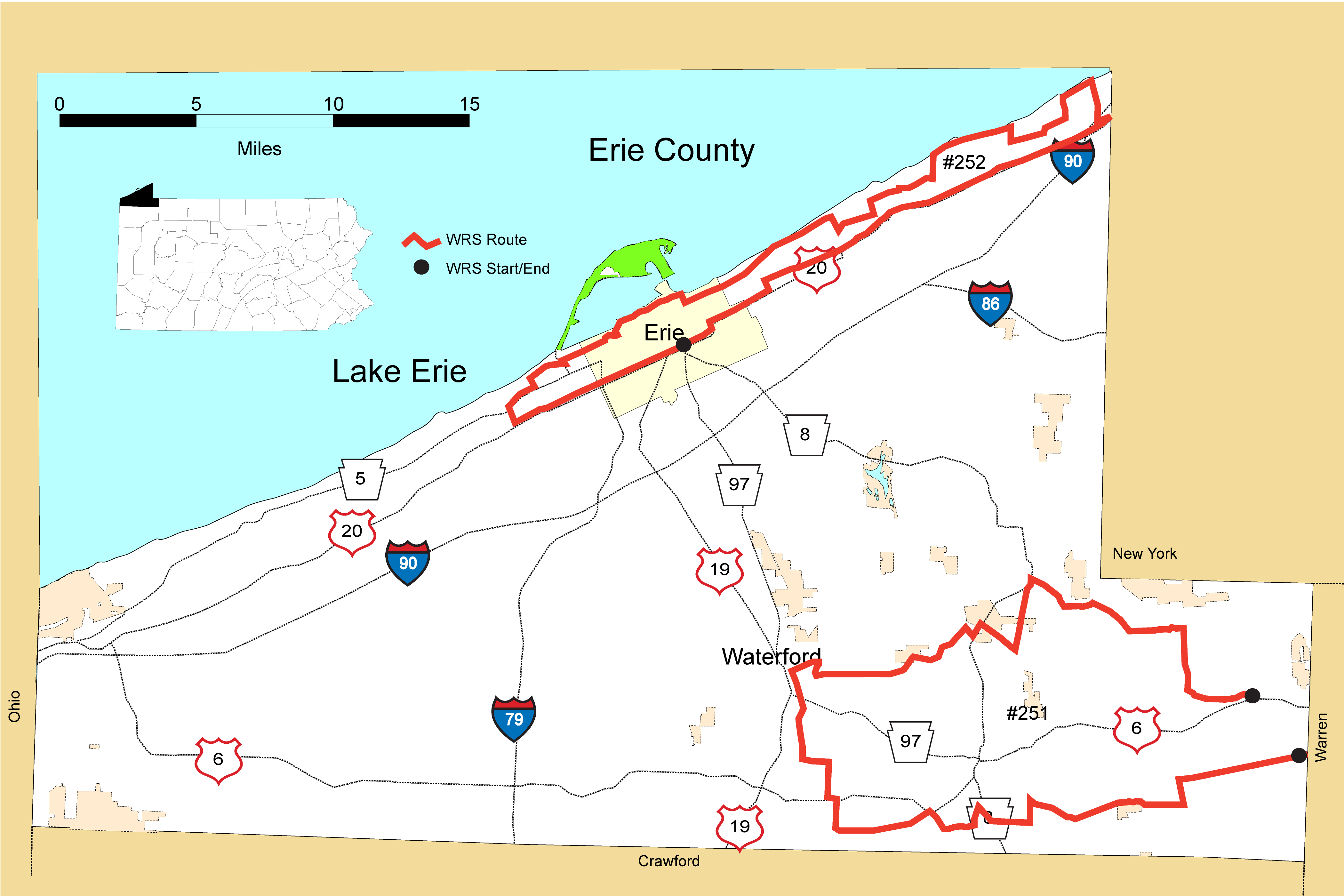
Route#: 251
Route Name: Erie SE
Compiler: Scott Stoleson
Directions: Route starts at county line on Stewart Rd, SE of Corry, PA.
Proceed west on Stewart to end.
Turn Left (South) on PA 89.
Turn right on Ormsbee Rd.
At 4-way intersection, take half-Left onto Nash Hill Rd.
At end of Nash Hill, turn Right onto Concord Rd.
At 1.8 miles, turn Left (S) onto Wilson Rd, proceed 0.8 miles to Holden Rd on left.
At end of Holden, take Right onto PA 8 for 0.1 mi, then quickly left onto Cooper Rd.
At end of Cooper, take hard Left onto Lincolnville Rd.
Turn Right at first opportunity (0.75 mi) onto Shreve Rd.
At end of Shreve, turn Right onto Old Valley Rd. Follow 0.86 miles to crossroads
Turn Left onto Old Meadville Rd, proceed 3.2 miles to Holmes Rd on Right
Take Holmes Rd north to end @ US 6. Turn left onto US 6,
Take first Right (at 0.3 mi.) onto Gourly Rd. and proceed N.
At end of Gourly turn Left onto Stone Quarry Rd.
At end, turn Right (N) onto Flats Rd, follow 3 miles into Waterford.
Turn Right onto East 3rd Street [aka Depot Rd] and continue east to T-intersection.
Turn Right onto Donation Rd, then a quick Left onto Hood Rd.
At end of Hood, turn Left onto Wattsburg-Waterville Rd, and follow east.
Cross Arbuckle Rd onto Hatch Hollow Rd and follow to PA 8 intersection.
Turn Left onto PA 8, then at 0.5 miles turn Right onto Casler Rd.
At end of Casler turn Left onto Old Wattsburg and follow NE to Lyons Rd.
Turn Left onto Lyons, go 0.15 mi. to end with PA 8. Turn Right on PA 8, then immediate Right onto PA 89.
Proceed SE on PA 89 1.5 miles to Hayes road on Left; follow Hayes to end.
Turn Left onto Follett Rd., follow to end.
Turn hard Right onto Buffalo Rd, follow to end.
Turn Left onto Turnpike Rd. Follow to end at US 6 in Corry – END ROUTE
Route#: 252
Route Name: Lake Erie Shore
Compiler: Mary Birdsong
Directions: Start at Intersection of US Route 20 and PA Route 8 (East 26th St and Parade St)
West on US Route 20 to Asbury Rd to PA Rt 5 (W 12th St)
PA Rt 5 east to Chelsea Ave. North to Alt PA Rt 5 (West Lake Rd) to PA 832 (Peninsula Dr.)
North to W. 6th St.
East on W 6th (which merges with Cherokee Dr for a bit!) to Cranberry St.
North on Cranberry St to Bayfront Parkway
East on Bayfront Pkwy to State St.
State St north -loop around Dobbins Landing
Bayfront Pkwy east to Ore Dock Rd.
Ore Dock Rd loop
Bayfront Pkwy east to Port Access Rd.
Port Access Rd loop
E Bay Dr to East Ave
East Ave Boat Ramp loop
South on East Ave to E 6th St
East on E 6th St becoming E Lake Rd (Alt 5) to Bartlett Rd
(Note: At Franklin Ave 12th Street in Erie PA Rt 5 turns north on Franklin Ave and meets up with Alt 5 and East Lake Rd is PA Rt 5 [no Alt] after that.)
South on Bartlett to Dutton Rd
East on Dutton Rd to Highmeyer Rd.
North on Highmeyer Rd to Lewis Rd
East on Lewis Rd to Moorheadville Rd.
North on Moorheadville Rd to Leet Rd
East on Leet Rd becoming W Middle Rd to Catholic Cemetery Rd
North on Catholic Cemetery Rd to Rt 5 (E Lake Rd)
East on Rt 5 to PA 89 (Freeport Rd)
Freeport Rd Loop (north)
South on PA 89 (Freeport Rd) to Middle Rd.
East on Middle Rd to Dewey Rd
North on Dewey Rd to Rt 5 (E Lake Rd)
East on Rt 5 to North East Marina
North East Marina Loop (north)
East on PA Rt 5 to Gay Rd
(sometimes we take Gay Rd north for a very short loop and back on to Rt 5)
South on Gay Rd to Stinson.
East on Stinson Rd to US 20 (this is right near the NY state line)
West on 20 (Buffalo Rd) to Intersection with Iroquois Ave PA 955
West on PA 955 to Nagle Rd.
South on Nagle Rd to US 20 (Buffalo Rd)
West on US 20 (Buffalo Rd) to Broad St where it turns south for a bit. Broad St becomes E 26th St. (still US 20)
West to the intersection of of US Route 20 and PA Route 8 (East 26th St and Parade St)
End
Route#: 253
Route Name: Erie NW
Compiler: Janet Price
Directions: Start at the Rice Ave (PA 18) and US 20 in Girard and go east On US 20.
Right on Daggett Rd.
Left on Barker Rd.
ight on Dobler Rd.
Right on Franklin Rd.
Left on PA 832 (Sterrettania RD).
Right on PA 98.
Left on Van Camp Rd.
Right on Eureka Rd.
Right on Stancliff Rd.
Left on PA 98.
Left on Old State Rd.
Right on Silverthorn Rd.
Right on Crane Rd.
Left on West Rd.
Right on Reservoir Rd.
Reservoir Rd goes right again.
Left on US 6.
Left on PA 226.
Right on Randell Rd.
Left on Akerly Rd to PA 226, then turn around and go back north on Akerly Rd.
Right on Cherry Hill Rd.
Left on PA 215.
Right on Old Albion Rd.
Left on Lexington Rd.
Right on Springfield Rd.
Right on Peach St.
Continue straight on Creek Rd.
Right on Francis Rd.
Left on Gudgeonville Rd.
Right on Beckman Rd.
Left on Franklin Rd.
Left on PA 832 (Sterrettania RD).
Right on Tannery Rd.
Right on US 20.
End at the Rice Ave.