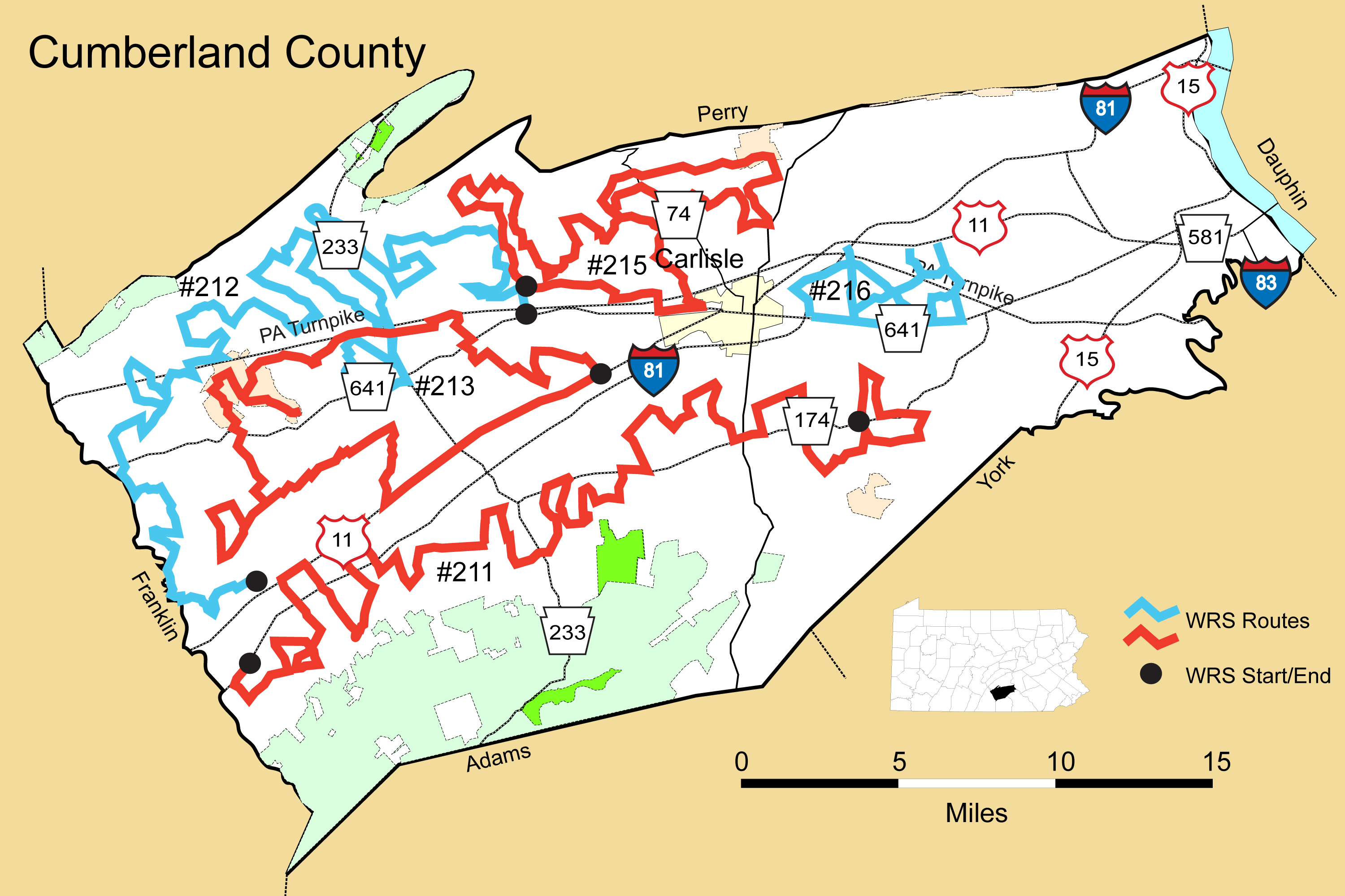
Details
Route#: 211
Route Name: Shippensburg to Boiling Springs
Compiler: Vernon Gauthier
Directions: Start in Shippensburg on Baltimore Road just south of Giant Food Plaza and northwest of I 81.
Go SE on Baltimore Rd.
Turn Right on Peiper at intersection with Baltimore (just after I-81)
Turn left on Cherry Grove
Turn left on McCulloch
Turn left on Baltimore
Turn Right on Cleversburg
Turn left on Neil
Turn Right on Airport
Turn Right on Whitmer
Turn Right on Walnutdale
Turn Right on Gilbert
Straight on High
Turn left on Goodhart,
Turn Right on US 11
Turn left on Foltz
Turn Right on PA 533
Turn Right on Brown
Turn Right on US 11
Turn left on Kline
Straight on Strohm
Turn left on Chestnut Grove,
Straight on Naugle
Turn left on Rehobeth
Straight on Hammond
Straight on Koser
Turn Right on Springfield
Turn Right on Oakville
Turn Right on US 11
Turn left on Fire House
Turn left on PA 174
Turn left on Water
Straight on Stoughstown
Turn Right on McCullough
Straight on Quarry Hill
Turn Right on PA 174
Turn left on High Mountain
Turn left on Mountain View
Turn Right on Pine
Turn left on Farm
Turn Right on PA 174 Walnut Bottom
Turn Right on Station
Turn left on Pine
Turn Right on Beetem Hollow
Turn left on Southside
Straight on Leeds (bear left at junction with Point Drive)
Turn Right on Pine
Turn left on Lebo
Turn left on Church
Turn left on Shank
Turn Right on PA 174 Walnut Bottom
Turn Right on Lebo Road
Turn left on Schaeffer
Turn left on Pine
Turn left on Encks Mill
@ T Junction Turn Right on Montsera (No sign)
Turn left on W. Yellow Breeches
Turn left on Stuart
Turn Right on PA 174 W Old York
Turn left on North Dickinson School
Turn Right on PA 465 Walnut Bottom
Turn Right on Burnt House
Turn left on Adams
Straight on Oak School
Turn Right on Rockledge
Turn left on PA 174
Turn Right on Zion (After intersection with PA 34),
Turn left on Park Drive
Turn Right on Petersburg
Turn left on Tanger
Turn left on Mountain
Turn Right on Leidigh
Turn left on Lutztown (Continue across PA 174)
Turn Right on Myers
Turn left on PA 74
Turn left on South Ridge
Turn Right on PA 174
Turn left on Front St.@ End – Boiling Springs Pond @Children's Pond parking lot
Route#: 212
Route Name: Newville North
Compiler: Vernon Gauthier
Directions: Start Intersection of PA 641 and Grahams Woods Road east of Newville at Saylors Market
Route 641 to (L) Grahams Woods (at intersection with Route 641)
(L) Creek
(R) Bloserville
(R) Potato
Potato Circles back around / @ Frytown go (R) (55+ Community)
(L) Grahams Woods (L) Kiss Me
(L) Wildwood
(L) Baughman into Bloserville
(S) 944 Enola – (R) Hoot Owl – Circle back to 944
(L) Buttermilk (Do not turn off on Mohawk or Brick Church before reaching Buttermilk)
(L) Rock Run
(L) Brick Church (TA)
(R) Mohawk
(R) Hunters
(S) McCrea (across 944)
(L) 233, (R) McCrea
(L) Pipeline, (L) Shed
(L) 997, (R) 233 Doubling Gap to Sheetz. (Pit Stop)
South on 233 (.7 miles already covered)
(L) Nealy Road
(R) Big Spring Road
(L) Route 533
(R) Fry Road
(S) Stamy Road
(L) Steelstown, (R) Wildwood
(L) Route 233 (1.8 mile already covered)
(L) Mohawk Road
(R) Center
(R) 997
(L) Mountain (L) Heckman
(R) Meadows (L) Mountain
(L) Middle
(R) Subdivision
(R) Whiskey Run
(L) Lay
(R) Brandy Run
(L) Mountain
(L) Etter – No Sign
(L) 997 Roxbury
(R) Gobbler Knob - Do not turn off on Bridgewater before
(L) Bridgewater
(R) Eberly (Along turnpike)
(L) Mountain
(R) Zion (Ignore Zion Hill Road)
(R) Potato Point (Before Hannah and Bear Hollow)
(L) Enola Road (L) Three Square Hollow
(L) Bear Hollow – Do not miss this
(R) Hannah (No sign)
(R) Three Square Hollow (No Sign)
(L) Hill Top
(L) Shady
(L) West Creek
(R) Route 696, (L) East Creek
(R) Jumper (R) Fox Hill
(R) Ridge Road, (S) Chamberlin
(R) Route 696
(R) Middle Spring Road, (R) Fish Hatchery Road
(R) Route 696, (L) Fogelsonger
(L) Britton (Pit stop at park)
(R) Smithdale
End - Intersection of Smithdale with Route 533
Route#: 213
Route Name: West Central Cumberland
Compiler: Dave Grove
Directions: Start at intersection of US 11 and Burnthouse Road, SW of Carlisle
South on US 11
Right (N) on Big Spring Road (SR 3007)
Left (W) on Nealy Road
Left (SW) on Shippensburg road (PA 533)
Right (W) on Redshed Road to Oakville
Right (N) on Oakville Road and left (SW) on Mud Level Road
Right (N) on Britton Road
Right (E) Ridge Road (SR 4004)
Right (SE) on Duncan Road
Left (E) on Mud Level Road
Left (N) on Kelso Road
Right (E) on Ridge Road
Left (N) on Running Pump road
Left (W) on Greenspring Road (PA 641)
Right (N) on Mountain Road (SR 4007) into State Game Lands 169
Right (NE) on Park Hill Road
Right (SE) on Bridgewater Road
Left (E) on Game Land Road, quickly Right (S) on Bridgewater Road
At end of Bridgewater Road, turn around, Right (NE) on Game Land Road
Right (SE) on Brandy Run Road (SR 4006)
Left (NE) on Whisky run Road
Right (E) on Creekview Road
Right (E) on Center Road
Remain on Center Road across Doubling Gap Road (PA 233)
Right (E) on Bluerock Road
Right (S) on Bridge Road
Right (SW) on Creek Road
Left (SE) on Crossroad School Road
Right (SW) on Carlisle Road (PA 641)
Left (SE) on Green Hill Road
Left (NE) on Wagners Lane
Right (SE) on Crossroad School Road
Left (N) on Kerrsville Road
Right (E) on Clay Road
Right (SE) on Greason Road
End at intersection with US 11
Route#: 215
Route Name: Cumberland NC
Compiler: Ron Freed
Directions: Start at intersection of Grahams Woods Road and Creek Road.
N on Grahams Woods Road
L on Enola Road
R on Lonesome Road
R on North Mt Road
L on Church of God Road
R on Grahams Woods Road
L on Bobcat Road
R on Long Lane
R on Enola Road (PA 944)
L on Old Mill Road
L on Burgners Road
L on Opossum Lake Road
L on Ponderosa Road
R on Pinedale Road
L on Opossum Lake Road (check the lake)
L on Easy Road
L on McClures Gap Road
R on Enola Road (PA 944)
At PA 74, east on Enola Road
R on Sheaffer Road
R on Wagner Drive
L on Cranes Gap Road
R on Creek Road
R on Pine Creek Drive
R on Long View
L on West View
L on Appalachian Ave
L on N Middleton Road
R on Longs Gap Road
L on Pine Hill Road
R on Waggoners Gap Road (PA 74)
L on Millwick Road
R on Stone church Road
L on McClures Gap Road
L on Easy Road
R on Willow Grove Road
L on McClures Gap Road
R on Newville Road (PA 641)
R on Meadowbrook Road
L on Alters Road
R on Bears School Road
R on Creek Road to bridge (out now for construction)
Return on Creek Road
R on Grahams Woods Road
End at intersection with Creek Road.
Route#: 216
Route Name: Cumberland NEC
Compiler: Tim & Karena Johnson
Directions: Start at S Middlesex Rd just south of US 11 near I-81 bridge
Right onto PA 641/Trindle Rd
Right onto Army Heritage Dr
Right onto Claremont Rd
Left onto S Middlesex Rd and immediate right onto Old Stonehouse Rd
Right onto PA 641/Trindle Rd
Right onto S Middlesex Rd
Right onto Ridge Dr
Right onto Old Stonehouse Rd and immediate left onto Biddle Rd
Left onto Kost Rd headed NW
Drive about a mile on Kost then make a U turn a little north of the RR tracks
Continue SE on Kost Rd
Right onto N Locust Point Rd
Right onto PA 641/Trindle Rd
Right onto Timber Rd
End at Timber Rd/N Locust Point Rd intersection