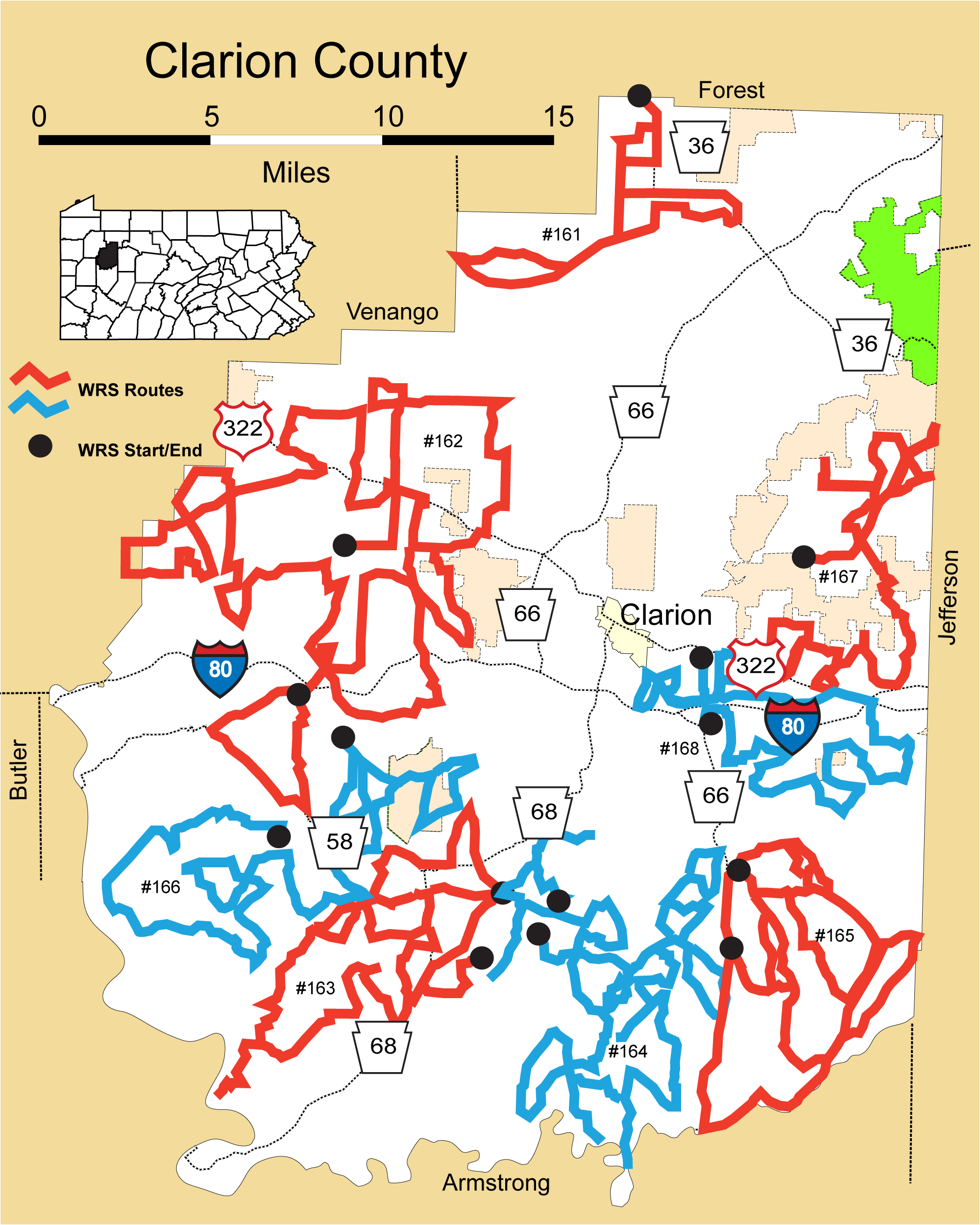
Details
Route#: 161
Route Name: North Clarion
Compiler: Eric Schill
Directions: Begin on PA 36 S at Forest-Clarion county line.
Right on Shetler Rd.
Left on Lake Lucy Rd.
Left on Washington Church Rd.
Continue straight onto PA 36.
Right on Sunny Rd.
Right on Putnam Rd.
Left on PA 208.
When 208 turns left, continue straight onto PA 157.
Sharp right on Gowdy Rd.
Road name changes to Bell Rd.
Left on PA 208.
Left on Lake Lucy Rd.
Right on Wolf Corners Rd.
Left on PA 36 back to county line.
Route#: 162
Route Name: West Clarion
Compiler: Michael Leahy
Directions: Begin at the intersection of PA 338 & Culbertson Road in Beaver Township just north of Knox, PA.
Proceed east on Culbertson Rd
Left on Ogden Rd
Right on US 322
Right on Fulton Rd
Left on PA 208
Right on US 322
Left on PA 208
Right on Allaman Rd
Left on Hearst Rd
Right on PA 208
Left on Millerstown Rd
Right on Pine City Rd
Left on Etzel Rd
Left on Cotton Rd
Left on Golf Course Rd
Right on Pine City Rd
Right on US 322
Left on Oak Grove Rd which turns into Ashbaugh Rd
Right on Bus Mong Rd
Straight across US 322 onto Kaber Rd
Left on Golf Course Rd
Left on Camp Coffman Rd
Left on US 322
Right on Saint Marks Rd
Straight across PA 338 onto Ninevah Rd
Straight on to Crossroads Church Rd
Left on Community Rd
Right on Neeley Rd
Left on County Line Road onto Kahle Lake access road.
Proceed back out from the lake to a left on North Kahle Lake Road
At this point we enter into Venango Co. for a short time in order to get around the lake.
Go left on PA 38.
Go left on South Kahle Road.
Left on Lake View Rd (now back in Clarion Co.)
Left on Community Rd
Right on Snively Corners Rd
Straight on Dog Leg Rd
Left on PA 208
Left on Nickelville Rd
Right on Ron McHenry Rd
Left on PA 208
Left on South Forty Rd
Right on Overlook Rd
Left on Cropps Corners Rd
Left on Kline Rd
Right on PA 208
Right on Rhea Lane
Left on Mehrten Rd
Right on Knox Rd
Right on Twin Church Rd
Left on Little Germany Rd
Right on PA 338
Left on Tippecanoe Rd
Left on Popetown Rd
Right on Shettler Rd
Right on Amsler Rd
Right on Huckleberry Ridge Rd
Left on Beaver Furnace Rd
Left on Buckhorn Rd
Left on PA 208
Left on Huckleberry Ridge Rd
Right on Tippecanoe Rd
Left on Knight School Rd
Right on Eagle Furnace Rd
Right on PA 338
Left on Ritts Station Rd
Right on PA 58
Left on Blairs Corners Rd
END - At the intersection of Blairs Corners Road and PA 38 in the village of Blairs Corners.
Route#: 163
Route Name: SW Clarion
Compiler: Carole Winslow
Directions: Route starts in the village of Curllsville, intersection of Huckleberry Ridge Rd and Curllsville Rd.
Start NW on Huckleberry Ridge Rd towards PA 68.
Straight through intersection with PA 68 and continue on Huckleberry Ridge Rd.
Turn Left on McEwen Rd.
Continue back to PA 68 and turn right.
Turn Right on Shamrock Rd.
Follow back to PA 58 and turn R
Turn Left on Morris Rd
Turn Left on Shannon Tipple Rd.
Turn Right on PA. 68
Turn Right on Huey Rd.
Turn Right on Mt Airy Rd.
Turn Left on Cherry Run Church Rd.
Turn Right on McCall Hollow Rd.
Turn Left on Callensburg Rd.
Turn Left Cherry Run Rd. at Y
Turn Left on Cherry Run Church Rd.
follow to intersection with McCall Hollow Rd and then return.
Turn Right back on Cherry Run Rd and follow to Bela, (staying on the road to left at next two intersections)
Turn Left on Dunlap Hill Rd at third intersection (pine plantation)
Turn Right on Monterey Rd.
Stay Right (straight) on Stahlman Rd.
Turn Right on Conneration Rd.
Turn Left on Sarah Furnace Rd. - follow to No Winter Maintenance Sign (road heads down through forest to Allegheny River) and then return to intersection.
Turn Right back on Conneration Rd.
Turn Left on Kissinger Mills Rd.
Turn Right on Monterey Rd and stay on this road through all intersections until reaching Summerville Rd.
Turn Left on Summerville Rd.
Turn Right on Toby Shed Rd.
At intersection with Cherry Run Rd, go straight (jogs to right) across on Thompson Rd.
Follow Thompson Rd up hill to intersection with Henry Rd and then return back to intersection
Turn Left on Cherry Run Rd. and follow into Rimersburg and intersection with PA. 68
Turn Left on PA. 68 and proceed through Rimersburg ,past cemetary and bear Left on Carwick Rd.
Follow Carwick Rd through to Tower Rd.
Turn Right on Tower Rd. and follow back to PA 68
Turn Left on PA 68 to proceed to Sligo
Turn Right on Logue Rd.
Follow to intersection and proceed straight (slight R, not hard Right on Campbell !) on McCall Rd.
Turn Right on Curllsville Rd.
Turn Left back on PA. 68
head back towards Rimersburg and turn Left on Reigel School Rd.
Stay Left at intersection with Switzer Rd
at next intersection turn Left on UP Church Rd ( Right is Kline Rd)
Follow UP Church Rd to 90 degree turn in road
At this area turn Right on Hilltop Rd. This is the Curllsville Strips area, follow road out over strips area to pond and route is complete
Route#: 164
Route Name: South-Central Clarion
Compiler: Carole Winslow
Directions: This Route starts at 159 Moggey Rd, Sligo 16255
head north on Moggey Rd.
left on Tintown Rd
Right on Borovick Rd.
stay to R on Over Rd at Y
Right on Five Points Rd
follow Five Points to S. Reidsburg Rd. and return
follow Five Points back past Over Rd and continue to Borovick
left on Borovick
Right on Kahle Rd.
follow Kahle Rd into Curllsville
in Curllsville left on Curllsville Rd
Right onto New Bethlehem/Curllsville Rd.
at first bend stay R (straight) onto Mud Rd. (may be Courson Rd in Google)
follow this road to Locker Rd.
Right on Locker Rd
follow to Twp Line sign and turn around
Follow Locker Rd back to intersection with Curllsville/New Bethlehem Rd.
left on New Bethlehem/Curllsville Rd
Right on Hill Rd
cross bridge and stay to the R on Hill Rd
follow Hill Rd past Moggey and up to T intersection
left on Magness Rd. (may be Bug Rd)
Right on Burns Rd and follow to intersection with S. Reidsburg Rd
Right on S. Reidsburg Rd.
Right on Rankin Rd
left onto Bug Rd
left onto Packing Rd.
Right onto Frosty Rd.
at farm stay R on Frosty
follow to Sheriden Rd
left on Sheriden
left on Henry Rd.
follow Henry Rd back to farm and intersection with Frosty Rd.
turn back R on Frosty Rd and back to Packing Rd.
Right on Packing Rd.
left on S. Reidsburg Rd.
Right on Brinkerton Rd.
follow to intersection with Olean Trail and go straight onto Swartfager Rd.
follow Swartfager Rd and Right on Champion Rd.
follow Champion Rd to PA 66
left on PA 66
left on Swartfager Rd.
Right onto Olean Trail
left on Skyline Rd.
Right on McMahon Rd
Right on Stoney then
Right on Ridge Rd. back to Olean Trail
on Olean Trail left
Left on Hoover Rd.
left on Stoney Rd.
left on Ridge Rd.
Right on Stoney Rd then quickly L on McMahon Rd.
Right on Skyline then very quickly L on Bus Rd.
follow Bus Rd to Brinkerton Rd.
Right on Brinkerton Rd.
left on Delp Rd.
Right on Olean Trail
Right on Church Rd.
left on S. Reidsburg Rd.
Right on Huber and follow to intersection with Old Maid Rd on L, turn around and return
back at intersection with S. Reidsburg stay straight on S. Reidsburg and follow to T with Olean Trail
Right on Olean Trail and follow to PA 861
Right on PA 861 and head west towards Rimersburg
left on Climax Rd.
follow Climax Rd to dead end sign/sharp right turn down to Redbank Creek- turn around and return
return on Climax Rd and at Falls Rd left
follow Falls Rd back to PA 861
left on PA 861
left on St Charles Rd, follow to Redbank Creek and county border, return to PA 861
left back onto PA 861
follow to Pyne Rd and left
follow Pyne Rd to Blair Rd
Right on Blair Rd and follow back to PA 861
cross over PA 861 onto Summit Ridge Rd.
at first intersection stay to R on Summit Ridge
follow Summit Ridge and Right on Squirrel Hill Rd.
left on Linwood Rd, just before PA 861
follow Linwood to New Bethlehem/Curllsville Rd
left on New Bethlehem/Curllsville Rd.
Right on Bug Rd
left on Packing Rd and back to New Beth/Curllsville Rd.
Right back onto New Beth/Curllville Rd (watch for the snowy owl on the L !) and proceed to intersection with Locker Rd on L, route ends here !
Route#: 165
Route Name: SE Clarion
Compiler: Carole Winslow
Directions: Route starts at Frogtown, intersection of Olean Trail and PA 66
Head east on Olean Trail into Frogtown
at Y in Frogtown stay Left on Olean Trail
continue to intersection with Shannondale Rd and turn Right on Shannondale
continue to PA 28 and go straight across
after crossing PA 28 will be on Macadam Rd.
continue on Macadam to Dairy Rd.
turn Right on Dairy Rd.
follow to PA 28 and turn L
follow PA 28 through New Bethlehem and turn Right onto Rt 66
follow PA 66 north back to Frogtown
turn Right on Olean Trail
in Frogtown turn Right at Y onto Frogtown Rd.
stay on Frogtown at 90 degree turn to left (straight is Windmill)
turn Left onto Townline Rd
follow Townline Rd to Shannondale Rd then turn around
return on Townline and turn Right on Megnin Rd.
go to Shannondale and turn back around on Megnin
turn Right on Conner Rd and go to end of road at intersection with Olean Trail, turn around and return
back at intersection with Megnin turn back R
then turn back Right on Townline and continue back to Frogtown/Truittsburg Rd.
turn Left on Truittsburg Rd
turn Left on Carriage Rd.
turn Left onto Pine Run Rd.
Turn Right on Shannondale Rd and go back to PA 28
turn Right on PA 28 and proceed to Longview Rd
turn Right on Longview Rd
turn back Right on Truittsburg Rd
turn Left on Windmill Rd.
follow to intersection with Frogtown Rd and turn back
proceed back on Windmill and turn Right onto Pumptown Rd.
follow to Hickory Ridge Rd and turn Left
follow Hickory Ridge back to Truittsburg Rd and turn back
back to intersection with Pumptown Rd and continue straight
after crossing Pumptown stay on Hickory Ridge Rd.
follow Hickory Ridge Rd back to PA 66 and route is complete
Route#: 166
Route Name: West-Central
Compiler: Michael Leahy
Directions: The route begins on SR 3007, Canoe Ripple Road at the bridge over the Clarion River and proceeds South on Canoe Ripple Rd
2.9 mi. Right on Whitmer Rd.
4.1 mi. Stay left at Y on Canoe Ripple Rd
5.4 mi. Right onto Elliot Rd
6.6 mi. Left on Mt. Zion Rd
7.6 mi. Right on Limestone Flat Rd
9.3 mi. Left on Wyman Rd
10.5 mi. Left on Stockdill Rd
12.2 mi. Left on Huckleberry Ridge Rd
12.4 mi. Left on Mt. Zion Rd
15.8 mi. Left on Hodil Rd
17.2 mi. Right on SR 58/368
19.1 mi. Left on Craig Rd
20.6 mi. Left on Mt. Airy Rd
24.3 mi. Right on Burns Farm Rd
26.3 mi. Right on Callensburg Rd
28.4 mi. Left on McCall Rd
30.0 mi. Straight onto Logue Rd
31.1 mi. Right on Spring Rd
33.0 mi. Right on Pollum Rd
33.1 mi. Right On SR 368
32.5 mi. Right on Myers Hollow Rd
33.7 mi. Right on Stephens Rd
34.9 mi. Left on Spring Rd
36.0 mi. Right on Zanot
36.7 mi. Right on Concord Church Rd
39.1 mi. Left on Doc Walker Rd
39.4 mi. Right on Terwilliger Rd
43.4 mi. Straight across SR 368 onto Lime Plant Rd
46.5 mi. Left on Pine Hollow Rd
51.0 mi. ROUTE ENDS at SR 368 & Pine Hollow Rd.
Route#: 167
Route Name: Strattonville North
Compiler: Mal Hays
Directions: Start at Intersection of US 322 and Seven Hills Road.
Go north on Seven Hills Rd
Right on Fair Haven Road
Right on Carney Road
Turn around at intersection of US 322
Go Back On Carney Road
Right on Deer Run Road
Right on Asbury Road
Left on US 322
Left on Day City Road
Right on Asbury Road
Left on North Conner Road ( No Outlet)
Turn around at "t" return to Asbury Road
Left on Asbury Road
Asbury Road Turns Into Old State Road
Right on Fisher Road
Left on Gravel Lick Road
Left on Lake View Road
Turn Around at Hindman Road
Return on Lake View Road
Left on Grave Lick Road
Right on Work Road
Right on Iron Bridge Road
Left on Fisher-Sigel Road
Turn around at Jefferson County Line
Right on Work Road
Right on Iron Bridge Road
Turn Around at Jefferson County Line
Right on Fisher Sigel Road
Left on Hinderson Road
Right on Spring Road
End at intersection of Spring Road and Fisher Road
Route#: 168
Route Name: Strattanville South
Compiler: Mal Hays
Directions: Start at Intersection of US 322 and Seven Hills Road.
Go north on Seven Hills Rd
Right on Fair Haven Road
Right on Carney Road
Turn around at intersection of US 322
Go Back On Carney Road
Right on Deer Run Road
Right on Asbury Road
Left on US 322
Left on Day City Road
Right on Asbury Road
Left on North Conner Road ( No Outlet)
Turn around at "t" return to Asbury Road
Left on Asbury Road
Asbury Road Turns Into Old State Road
Right on Fisher Road
Left on Gravel Lick Road
Left on Lake View Road
Turn Around at Hindman Road
Return on Lake View Road
Left on Grave Lick Road
Right on Work Road
Right on Iron Bridge Road
Left on Fisher-Sigel Road
Turn around at Jefferson County Line
Right on Work Road
Right on Iron Bridge Road
Turn Around at Jefferson County Line
Right on Fisher Sigel Road
Left on Hinderson Road
Right on Spring Road
End at intersection of Spring Road and Fisher Road