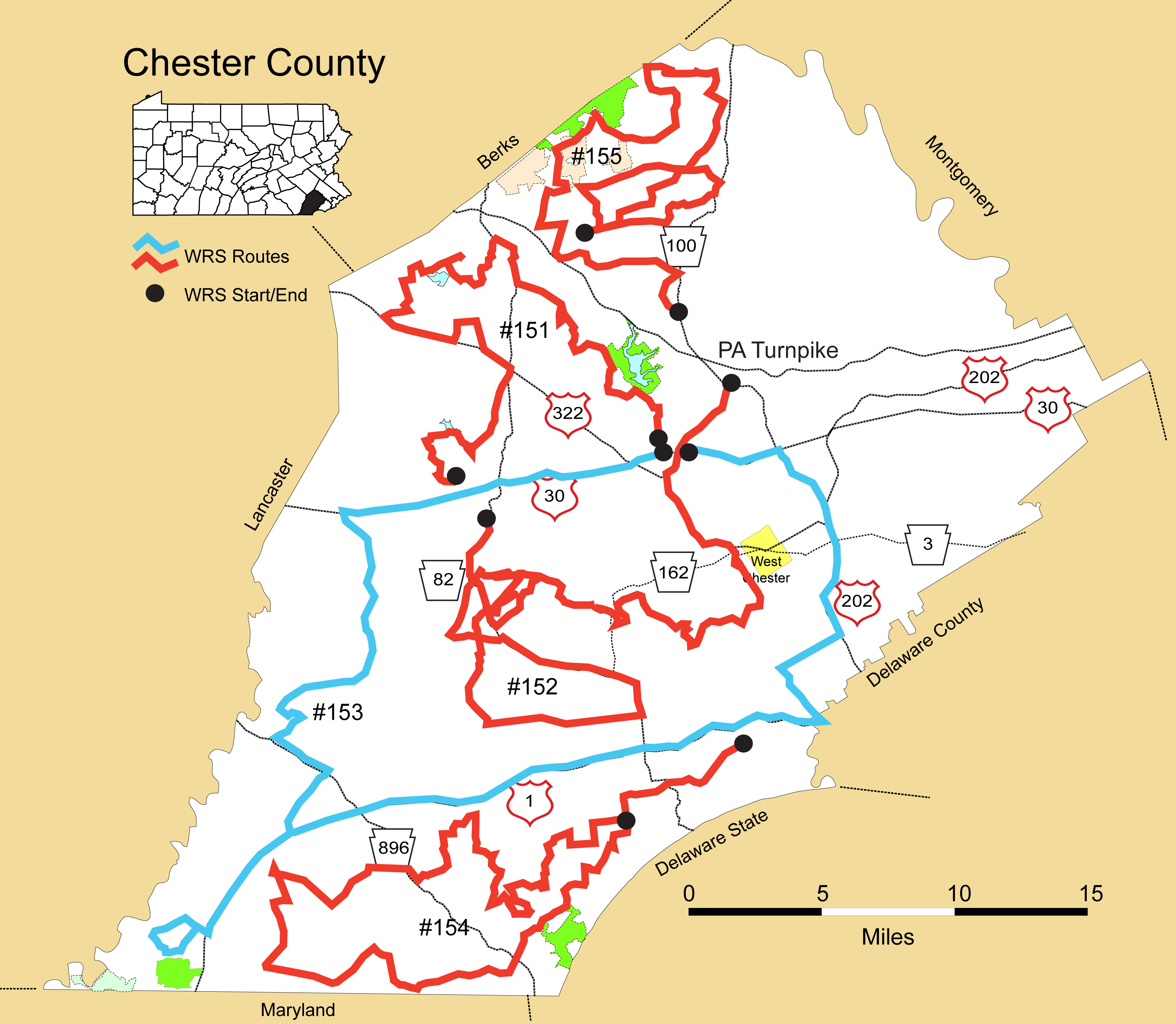
Details
Route#: 151
Route Name: NW Chester
Compiler: Rick Robinson
Directions: PA 282 North from US 30
to Fairview Rd west (vulture roost, spot check)
to Indiantown to PA 282 N
to PA 82 N to Bollinger Rd
to Isabella Road (west) --check fish hatchery for eagles, etc.
to N Morgantown Road (check struble lake for hawks, shrikes, owls)
to White school Road (will check White School to Twp line to Chestnut first before heading W on White School) West to Talbotville N
to Homestead Rd South
to Pleasantview S
to Suplee West
to PA 82 South
to Cupola North
to Grieson to
Chestnut Tree S
to US 322 S
to PA 82 S to Hibernia Road S
to Wagontown N (checking Chambers Lake)
to Martin's Corner W
to Creamery S
to Reservoir S (check Coatesville Reservoir)
Route#: 152
Route Name: West Central Chester
Compiler: Rick Robinson
Directions: From Lionville:
START: PA 113 S to US 30 East
US 322 East to Creek S
to PA 842 West
to Northbrook N
to Brandywine Dr W
to PA 162 West
to Buck Run Road
to Doe Run Station E to Chapel
to PA 841 (up and down side roads along this road)
to PA 82 South to Unionville
PA 926 West to Chatam N
to Springdell N to Rokeby
to PA 82 South to Dupont East
to PA 162 W to Frog Hollow S to PA 82
PA 82 North to US 30 by-pass East
to PA 113--END
Route#: 153
Route Name: SW Chester
Compiler: Chris Pugliese
Directions: Start: From PA 113 and US 30 by-pass West to Pa 10
PA 10 South to Homeville West
to High Point to Glenville SW
to PA 10 South
to US 1 south
to PA 272 W to Cemetery S
to Park Rd W to PA 272
to US 1 South
US 1 North to Creek Rd N
to PA 926 East
to US 202 N ( I don't think we count here)
to PA 100 N
to US 30 by pass W
to Pa 113--END Route
Route#: 154
Route Name: Southern Chester
Compiler: Scott Stollery
Directions: Start at Kennett Pike & Hillendale (between Kennett Square and Chadds Ford
Go west (turn right) on Hillendale Road (travel for 5.5 miles)
Left on Sharp Road (twists and turns for 1.4 miles)
Left on Pine Valley Drive
Right on Pyles Mountain Lane (go to the end, scan and turn around)
Left on Pine Valley Drive
Left on Sharp Road
Left on Hartefeld Drive
Right on Kaolin Road
Right on Gap Newport Pike (Route 41)
Left on Sunny Dell Road
Left on Newark Road
Right on Laurel Heights Road
Left on Walnut Run Road
Right on Landenburg Road
Left on Penn Green Road
Right on Good Hope Road
Left on Flint Hill Road
Right on Strickersville Road
Right on Appleton Road (drive up a way, scan and turn around)
Right on Strickersville Road
Right on Schoolhouse Road (drive to end, scan and turn around)
Right on Strickersville Road
Left on Lewisville (Chesterville?) Road (Route 841)
Right on Lewisville Road/Route 472 (at Elk Township Municipal Building)
Left on Lewisville Road/Route 472 (at Mateo's Pizza)
Right on State Road (4-way stop, no road sign)
Right on Chrome Road
Right on Mt. Olivet Road
Right on Media Road
Left on Mt. Pleasant Road
Right on Water Way Road
Left on 5th Street
Straight on N. 5th Street (Turns into Chase Street)
Right on Rt. 10
Left into Oxford Walmart Wetland area and scan
Turn right back onto Rt. 10
Left on Market Street (472)
Keep right onto Hickory Hill Road
Left on Little Elk Creek Road (go past Elk Creek Road!)
Right on Oxford Road
Right on 896
Left on State Road
Right on Avondale Road
Right on Pennock Bridge Road (no road sign)
Left on School Road
Right on State Road
Left on Sunnyside Road
Right on Kelton Road
Left on Valley Road
Right on S. Guernsey Road
Left on E. Avondale Road
Right on Wickerton Road (Route 841)
Right on Wickerton Road again (Route 841)
Right on Old Schoolhouse Road
Left on Chesterville Road (Route 841)
Right on Flint Hill Road
Left on Mercer Hill Road (the visible road sign after the bridge says Old Post on the right, but turn left)
Left on N. Creek Road (keep an eye out for BAEA nest on right)
Right on Route 841 (go past Mercer Mill on the right)
Left on N. Creek Road (becomes Church Hill Road and at the end of the dirt road keep right)
Left on Clay Creek Road
Right on New Garden Station Road
Left on Ellicot Road
Right on Cooper Road
Right on Penn Green Road
Left on Starr Road
Turn into New Garden Township Park on left to scan and finish survey
Route#: 155
Route Name: N Chester
Compiler: Scott Stollery
Directions: Begin Pottstown Pike and Font Rd
Left on Font Rd
Right on St Andrews Lane
Left on Conestoga Rd
Left on Moores Rd (this becomes Marsh Rd)
Left on Conestoga Rd
Left on Creamery Rd
Right on Hedge Rd
Right on Bulltown Rd
Right on Ridge Rd
Left on S Brick Lane
Left on Conestoga Rd
Left on Mansion Rd
Left on Reading Furnace Rd
Right on Mine Hole Rd
Left on Morningside Rd
Left on Warwick Rd
Right on Pine Swamp Rd
Right on Harmonyville Rd
Left on Bethesda Rd
Right on Hopewell Rd
Left on Harmonyville Rd
Left on Chestnut Hill Rd
Right on Coventryville Rd
Left on St Peters Rd (becomes Unionville)
Right on Shenkel Rd
Right on Temple Rd (bear Right on Temple at split)
Left on Catfish Ln
Right on W Cedarville Rd
Right on Sheep Hill Rd
Left on Temple Rd
Right on Laurelwood Rd
Right on Old Ridge Rd
Right on Ridge Rd
Left on Grove Rd
Left on James Mill Rd
Left on Nantmeal Rd
Left on Valley Way Rd
Right on Warwick Furnace Rd
Left on County Park Rd
Right on Mt Pleasant Rd
Right on Ridge Rd
Right on Daisy Point Rd
Right on Pottstown Pike
Right on Prizer Rd
Bear Right on Murray School Rd
Left on Coventryville Rd
Left on Coventryville Rd again
Stay Straight Nantmeal Rd
Bear Right on Nantmeal Rd
End at Pottstown Pike