Details
Route#: 021
Route Name: West Allegheny
Compiler: Mike Fialkovich
Directions: Begin at Fort Pitt Tunnel on PA 51 in Pittsburgh.
Continue on PA 51 to the McKees Rocks Boat Dock.
Continue on PA 51 through McKees Rocks and turn right onto Neville Island.
Return to PA 51 in Coraopolis and continue on PA 51 to Flaugherty Run Road.
Turn right onto Flaugherty Run Road and in about two miles turn right into Dashields Dam.
Drive to the parking area near the dam.
Return to Flaugherty Run Road, turn left and take it to Clinton. (Note when nearing the airport, the road gets a little confusing.)
Follow the sign to Clinton after crossing Business PA 60.
The road to Clinton (Flaugherty Run Road) is permanently closed from Business PA 60 to Express PA 60.
At Express PA 60, take the entry ramp to the right (there is a small sign here for Clinton (2 miles) and get on PA 60 South back towards the airport.
Take the first exit and at the end of the ramp, turn right back onto Flaugherty Run Road and follow it to US 30 in Clinton.
At US 30 in Clinton, turn left.
Turn right onto Burgettstown Road and follow it past (now closed) Point Park Road.
Turn left on Potato Garden Run Road and continue to the Truck Stop
Continue into Washington County
Turn right onto Ridge Road and re-enter Allegheny at the Toy Airport to check the fields.
Backtrack to Potato Garden Run Road and turn right onto Boggs road passing the Imperial
Land Fill and the Montour Bike Trail back to US 30 in Imperial.
Turn right onto US 30 and take it to the PA 22/US 30 Interchange.
Take PA 22/US 30 East back to the Fort Pitt Tunnel and the end of the route.
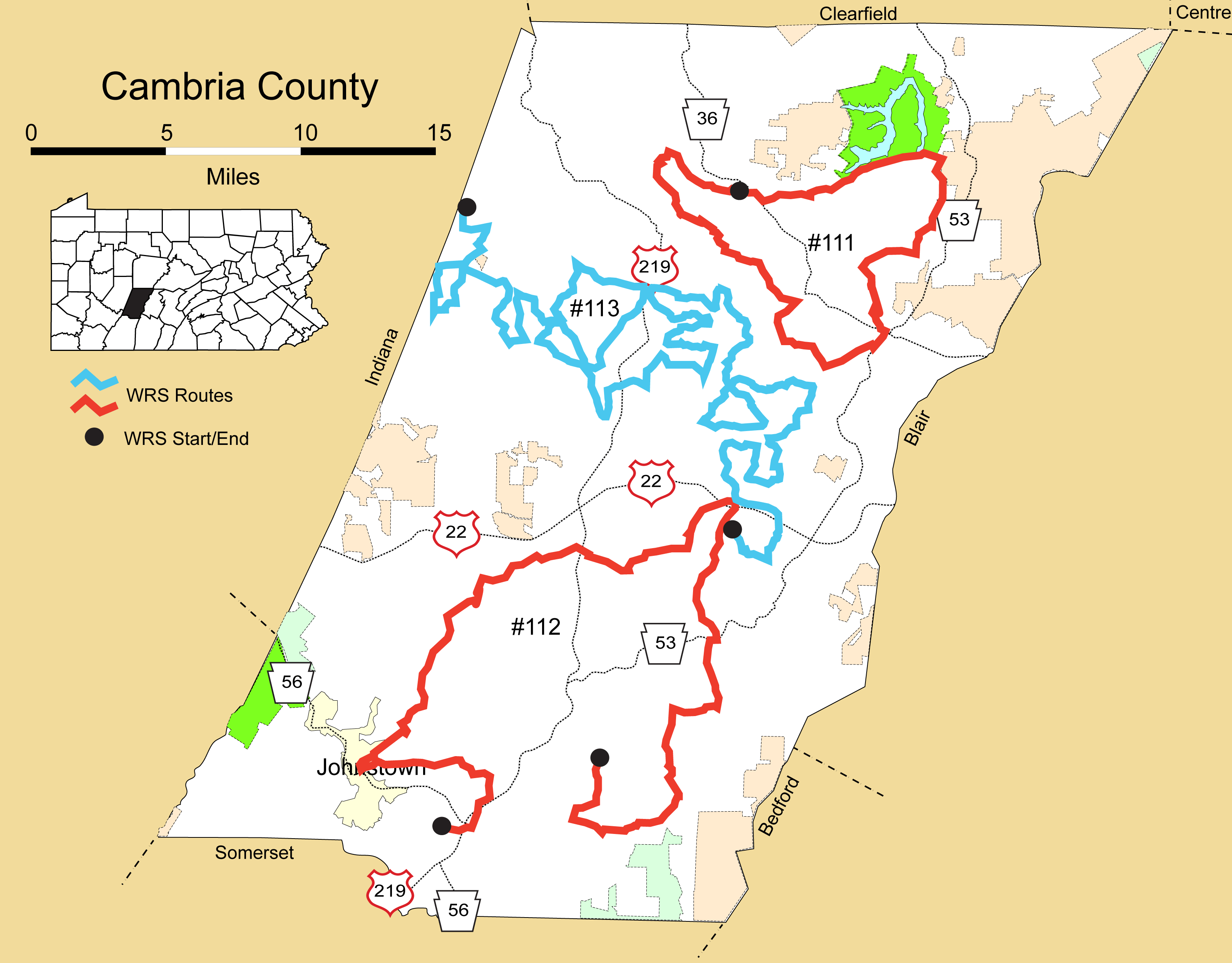
Route#: 112
Route Name: South Cambria
Compiler: Brad Romano
Directions: Start at Intersection of Bedford St and Oakridge Dr in Geistown
East on Oakridge Dr
Left on Galleria Dr
Right on Solomon Run Rd
Left on Airport Rd (SR 3031)
Left on Frankstown Rd (SR 3034)
Right on PA 271
Right on Adams Ave
Right on Ogden Rd
Left on Stagers Rd
Right on PA 160 (then bear left to stay on 160)
Left on Wilmore Rd
Right on Howell Hill Rd
Left on Kosaber Rd
Right on Spinner Rd
Right on Admiral Perry Hwy (SR 2014)
Right on PA 164
At the south end of Portage, bear right on Springhill Rd
Right on Frankstown Rd (SR 2006)
Left on Washington Ave (SR 2007)
Right on Cedar St
Left on Cameron Ave
Continue Straight on Dunlo Dip Rd
Right on Coulter St
Left on Pitcairn Ave
Continue Straight on Peaceful Valley Rd
Right on PA 160
End at Junction with PA 869
Route#: 113
Route Name: Cambria Central
Compiler: Gloria Lamer
Directions: Start at intersection of Rt. 553 and Killen School
Road. (40.624892; -78.845831)
Turn onto Killen School (SR 4001).
Left on Luther Road (T 523)
Right on Waterfalls Road (T 507)
Left on Log Road (T 513)
Right on Water Plant Road (T 506)
Straight on Killen School Road (SR 4001)
Left on Killen School Road
Sharp left on Elzi March Road (T 496) which, at the
township line becomes:
Dutch Run Road (T 496)
Right on Amadei Road (T 509)
Straight on Rt. 271 - Duman Road
Right on Wolfe Road (SR 4007)
Bear right on Priesser Road (T 490)
Left on Snake Road (SR 4002)
Left on Wolfe Road (SR 4007)
Right on Farabaugh Road (T 500) which becomes
Lute Road at the township line
Straight on Lute Road (rt around the corner) (T 801)
Left on Vetera Road (T 494)
Right on Vetera which turns into Stevens Road at
twp. line (T 495)
Left on Lieb Road (T 494)
Right on Rt. 553
Right on Rt. 219
Right on Colver Road (SR 4005)
Right on Tripoli Road (SR 4002)
Right on Lute Road (T 801)
Left on Vetera Road (T 494)
Left on Snake Road (SR 4002) to Tripoli (SR 4002)
Right on Gresh Road
Lunch
Left on Colver Road (SR 4005)
Right on Friend Lea (SR 1002)
Left on Plank Road (SR 4031)
Right on Lemon Drop Road (SR 1007)
Right on Cunningham Road (T 481)
Left on Campbell (T 454)
Left on Lemon Drop Road (SR 1007)
Right on Buck Road (T 486)
Left on Old Brick Road (T 465)
Bear left on VFW Road (T 511)
Right on Twenty Mine Road (T 484)
Right on 219
Right on Old Brick Road (T 465)
Left on Kane Road (T 512)
Left on Farabaugh (T 468)
Right on Dutch Road (SR 1007)
Right on Beck (T 486)
Left on Brick (SR 1007)
Straight on Loretto (Brick) Road
Turns into Manor Drive (SR 1001)
Right on Stock Road (T 462)
Straight across Brick onto Eckenrode (T 482)
Left on Columbia Street (SR 1001)
Immediate right on Sharp Road (T 481)
Right on Lincoln Road (SR 1011)
Right on Trexler Road (T 463)
Right on Syberton (SR 1006)
Left on St. Mary Street (SR 1005)
Straight on Joseph Street (SR 1005)
Bear right on Itle Road (T 442)
Left on Hoover Road (T 446)
Right on Vale Wood Road (SR 1004)
Right on Dream Road (T 444)
Straight on Metz (name change at Twp. line)
Left on Thomas (T 460)
Left on Munster Road (SR 1003)
Left on Admiral Perry Highway (SR 2014)
Right on Cooney Road (T 436)
Straight on Colonial Road (T 431)
Right on Noels Creek Road (T 433)
End at Trees