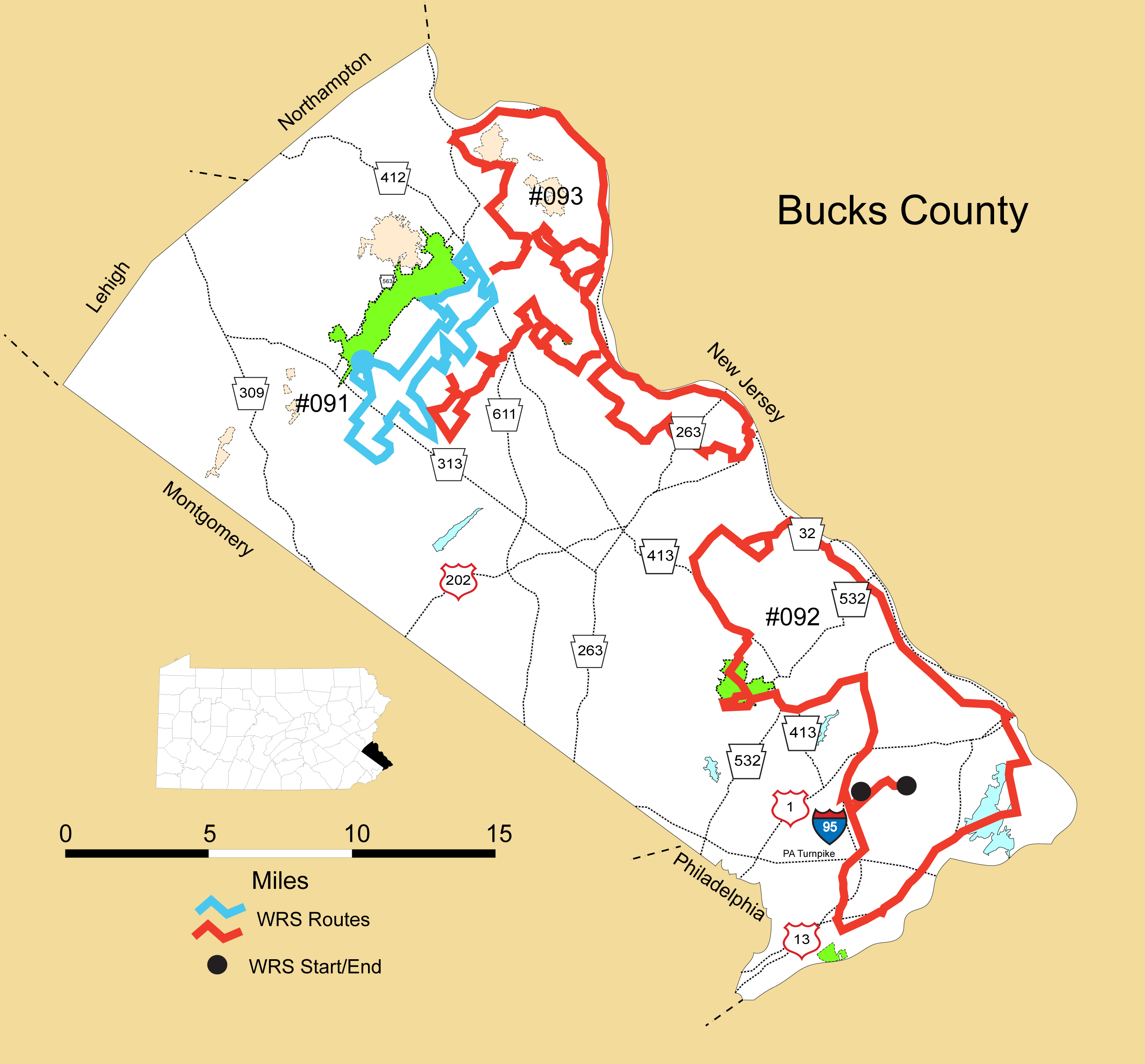
Details
Route#: 091
Route Name: Central Bucks
Compiler:
Directions: Start at St Peter's UCC on Old Bethlehem Rd
Left on Sterner Mill Rd and left on 3 Mile Run Rd.
Left on Butler Lane
Left on Ridge
Right on Old Beth
Right on 5th
Left on Schwenkmill
Right on Branch
Left on Blooming Glen (stop at Mennonite Church to scan)
Left on PA 113
Left on Minsi (map shows loop off Minsi onto Schwenkmill Rd to R. on Blue School & back to Minsi)
Right on PA 313
Left on Schott
Right on Bucks
Right on Blue School
Left on Bucks
Left on Elephant
Right on Center School (stop at farm to scan)
Left on Fretz Valley
Stay on Fretz Valley past Keller's Church Rd. about 1500 feet (edge of fields) and reverse back to Keller's Church
Left on Keller's Church/Creamery Rd.
Left on PA 113
Left on Rolling Hills
Right on Farm School
Left on Durham
Left on Tohickon Valley
Right on Creamery
Left on Durham merge on PA 611 North and continue to light at Tower Rd. and reverse back to Foellner Ln.
Right on Foellner Ln
Right on Fink to Tower Rd. and reverse back down Fink Rd.
Right on South Park
Right on Mink Rd(Google map says Fairview Rd. but sign says Mink)-Go to end and return.
Right on gravel state park rd that loops back out to South Park(becomes Yost School Rd. on south side of South Park)...cross South Park and follow Yost School Rd.
Left on Mink Rd. (this may say Fairview Rd. on road sign but Mink on Google?) short distance and R on Yost School Rd.
Right on Yost School Rd. to Sweetbriar Rd.
Left on Sweetbriar
Right on Rolling Hills Rd.
Right on Fretz Valley Rd
Right on Perry Rd.
Left on Sweetbriar Rd.
Right on Elephant
Left on Creek Rd.
Left on Old Bethlehem back to St Peter's UCC.
Route#: 092
Route Name: SE Bucks
Compiler: Linda Rowan
Directions: Start at home S. on Hawk Road (in Highland Park section of Levittown, in Middletown Twp),
Right on Trenton Rd,
Left on New Rogers Rd,
Right on New Falls Rd,
Left on Newportville Rd,
S on Bristol Pike (PA 13),
Left on Cedar Ave (in Croydon),
Left on State Road,
Left on Durham Road (PA 413)
Right on Old Route 13 ((Bristol)
Right Canal's End Rd, through Mill St Parking Lot, exit onto Radcliffe St, (name changes to Main St. in Tullytown, continues as Bordentown Road,
Left on New Ford Mill Rd,
Right on Tyburn Rd,
Left on Pennsylvania Ave (name changes to Yardley-Morrisville Road, then name changes again to Main St. through Yardley, then name changes again to Taylorsville Road,
Left on River Road,
Left on Lurgan Rd,
Left on Street Rd,
Left at Thompson Mill Rd,
Left on Eagle Rd,
Left on Lurgan Rd,
Right on VanSant Rd thru covered bridge, turn around & back to Lurgan Rd,
Right on Street Rd. (Street Rd makes a 90 degree turn to the right, but we kept straight onto Ridge Rd,
Right onto New Rd, Left onto Pineville Road, Left on Durham Rd (PA 413), Right through Tyler State Park
Left onto Richboro Rd which continues on to become Newtown Bypass then Newtown-Yardley Rd,
Right onto I 95,
Left on Lincoln Hwy,
Right onto New Rogers Rd (PA 413),
Left onto Trenton Road,
Right on Olds Blvd.
End at Oxford Valley Rd.
Route#: 093
Route Name: Northeast Bucks
Compiler: Katherine Martens
Directions: LEG 1
Start at Route 32 (River Rd.) and U.S. 202. North on Route 32 (A) à do at the end of Leg 6
Left on Cafferty Rd. (B) à Duncan!
Right on Twin Lear Rd. (C)
Left on Mt. Airy Rd. (D)
Left on E. Dark Hollow Rd. (E)
Right on Cafferty Rd. (F)
Right on Hollow Horn Rd. à 3 way intersection, Hollow Horn still called Cafferty here on G. Maps, covered bridge, G in wrong spot?
Right into Van Sant Airport. Return to Hollow Horn, turn right (H)
Right on Headquarters Rd.
Bear Right on Tinicum Creek Rd.
Left on Route 32 North (I)
LEG 2
Along 32 north divert to Sand Castle Winery, Geigel Hill Rd., Tinicum County Park, and Giving Pond (Delaware Canal State Park) (A, B, C, D)
Continue on Route 611 South (E)
Left on Kintner Hill Rd. (F)
Left on Lake Warren Rd. (short distance) (G)
Left on Natures Way to Lake Warren, and return to Lake Warren Rd., turn left (H)
Right on Marienstein Rd. to end (I)
LEG 3
Left on Beaver Run Rd. (J)(A)
Bear right on Bunker Hill Rd, then return to Beaver Run Rd. and turn right (B)
Left on Clay Ridge Rd. (short distance)
Left on Geigel Hill Rd. (short distance) (C)
Right on Cafferty Rd.
Left on Headquarters Rd. (D) à don't bird between here & Center Rd./August Mirabella
Left on Center Rd.
Right on Rope Walk Rd. (E)
Left on Geigel Hill Rd. (F) BREAK in Ottsville (G) à Brig O'Doon – closed Mondays
LEG 4
RESUME at Route 113 (Bedminster Rd.) and Hill Rd, head south on Hill Rd. (A)
Right on Irish Meetinghouse Rd. (B)
Left on Elephant Rd. (C)
Left on Twin Oaks Rd.
Left on Deep Run Rd.; Pass Keller's Church Rd., continuing on Deep Run Rd. (D)/(E)
Left on Quarry Rd. (F) à then R. on Creek Rd.
Left on Rolling Hills Rd. Continue to Fatima House then turn around (G)
Left on Creek Rd. Continue across Route 611 (H) on Randt's Mill Rd. (I)(J)
LEG 5
Continue on Oak Grove Rd. (A) à Gruver Rd.?
Right on Gruver Rd.
Left on Ervin Rd. (B)
Right on Hollow Horn Rd.
Right on Red Hill Rd. (C)
Right on E. Dark Hollow Rd. (short distance) (D)
Left on Stover Park Rd. Go nearly to end, turn around at covered bridge (E)
Left on Iron Bridge Rd. Go to end, turn around at Tohickon Creek (F)
Continue Turn left on Stover Park Rd.
Left on E. Dark Hollow Rd. (bear left to stay on road across bridge) à near Stover-Myers Mill
Across covered bridge bear left on Tohickon Hill Rd. (a.k.a. Covered Bridge Rd.) à L. to stay on Covered Bridge Rd./Tohickon Hill Rd.
Right on Toll Gate Rd. (G)
Left on Groveland Rd. (pass Shull Family Farm) (H)
Slight right on Tohickon Hill Rd.
Right on Point Pleasant Pike (I)
LEG 6
Left on Toll Gate Rd. (A)
Left on Sladek Rd. Continue to dead end at farm, turn around. (B)
Turn/Continue left on Toll Gate Rd. (short distance)
Right to stay on Toll Gate Rd.
Left on Wismer Rd.
Left on Carversville Rd. then quick right on Aquetong Rd. (C)
Left on Mechanicsville Rd. à 4 way stop
Right on Creamery Rd. (D) à Solebury Orchards
Left on Upper York Rd.
Quick right on Creamery Rd. (divert into Honey Hollow Preserve) (E) à Bucks Co. Audubon Society
Left on Meetinghouse Rd.
Right on Sugan Rd. (bear left to stay on Sugan)
Left on Lower York Rd (Route 202) (F)/(G) à Bird all the way back to Pt. Pleasant