Details
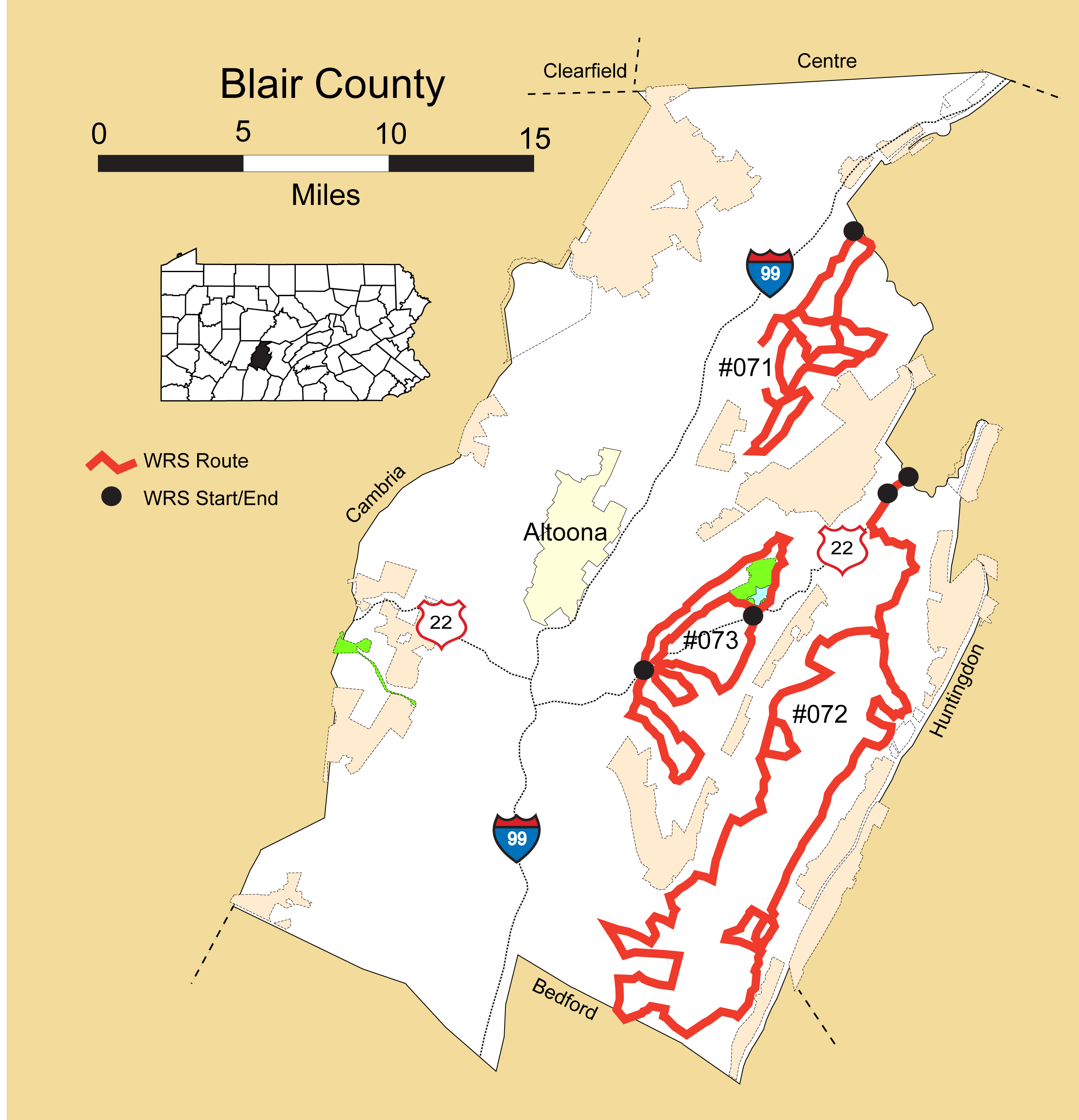
Route#: 071
Route Name: NE Blair
Compiler: Duog Wentzel
Directions: Follow PA 453 E 1 mile from Tyrone, turn left after sewer plant onto SR1015 into Tyrone Forge, the north end of Sinking Valley.
Follow SR 1015, Quarry Rd., 3.7 mi. SW to intersection with SR 1008, Skelp Mountain Road, and continue straight 0.7 mi. through Skelp.
Left, SW, on Hobbit Hollow Rd., T 603, and follow it 1 mi. to the turn around. Retrace to Skelp Mt. Rd. and turn right.
Retrace east 0.3 mi. on SR 1008 and turn right on Golf Course Rd., SR 1015), SE 0.5 mi. then S 2.5 mi. to Culp intersection.
Turn right, SW, on the Kettle Rd., SR 1013, drive 0.7 mi. to Ft. Roberdeau Rd. and turn right. Drive 0.4 mi., take right fork into fort area, and retrace to Kettle Rd.
Turn right, SW, on the Kettle Rd., SR 1013, follow it 1.8 mi. to Sickles Corner, and turn left on Sickles Corner Back Rd., T 484
Follow Sickles Corner Back Rd. NE 3.1 mi. back to the Kettle Rd., SR 1013.
Turn left, SW, on the Kettle Rd. for 0.5 mi. to Culp intersection, right on Golf Course Rd., SR 1015, retrace for 0.1 mi., and turn right, NE, on T 526, Stevens Hill Rd.
Follow T 526 NE 1.1 mi. to Sinking Valley Lutheran Church, turn right, E, on T 596, Lime Kiln Rd. and drive 1.1 mi. to Kettle Rd., SR 1013. Turn left.
Follow the Kettle Rd., SR 1013, NE for 1.3 mi. and turn left on T 495, Morrow Rd.
Follow T 495 W for 2.1 mi., nearly to Lutheran Church; turn right on T 496, Crawford Rd.
Follow T496 NW 1.4 mi. to intersection with Golf Course Rd, SR 1015 and go straight.
Retrace on SR 1015 0.5 mi. NW into Skelp, turn right, retrace on SR 1008 east 0.4 mi., then fork right, continuing E on SR 1008, Hileman Rd. for 1.5 mi.
Turn right, S, on T 489, Burket Rd., drive 1.1 mi. to intersection with T 495, Morrow Rd., turn left, E, and retrace 0.9 mi. to Kettle Rd.
Turn left, NE, on Kettle Rd. drive 1.0 mi. to Arch Spring Presbyterian Church and turn left, West, on SR 1008, Hileman Rd..
Follow SR 1008 W 1.8 mi. and turn right, N on SR 1017, Silver Barn Rd.
Follow Silver Barn Rd. N 3.0 mi. to PA 453, the north end of Sinking Valley and end of raptor survey.
Route#: 072
Route Name: SE Blair - Clover Creek
Compiler: Greg Grove
Directions: Start on US 22 at Blair/Huntingdon county line.
Left on SR 2015
Left on Cross Valley Rd T459
Right on SR 2017
Left on SR 2015 to Williamsburg
From Williamsburg – Cedar Hill Rd T443
Right on Lower Clover Creek Rd T454
Left, uphill, at Yield sign
Right on Biddle Rd T397
Left on Mill Hill Rd T395
Left on SR 2011 Clover Creek Rd
Left on Fairview Rd T385
Left on SR 2011 Clover Creek Rd
Left on Rebecca Furnace Rd
Right on Mill Race Rd T341
Right on SR 2011 Clover Creek Rd
Left on Claybank Rd
Left on Fair Valley Rd T344
Left on PA 164
Right on SR 2001
Right on Auction Rd SR 2005
Left on Crossroads Lane Rd T309
Right on SR 2001 Henreitti Rd
Right on PA 866 Curryville Rd
Left on Drake Rd T309 (in Curryville)
Right on PA 36 (0036)
Right on Kensinger Rd T318
Right on Carper Rd T319
Right on Cove Lane Rd SR2006
Left on PA 866
Left on Cross Cove Rd SR 2004
Right on Cove Lane Rd SR2006
Right on Frederick Rd T343
Left on Nicodermis Rd T339
Right on PA 164
Left on Agway Rd
Right on Lock Mountain Rd
Left on PA 866
Right on Sportsmen's Rd T537
Left on Poverty Hill Rd
Right on PA 866
Right on Royer Rd
Left on Miners Lane
Right on PA 866
Left on Short Cut Rd T375
Right on Lower Piney Creek Rd T378
Right on Airport Rd T441 -> Williamsburg
North on SR 2015
End at US 22 (Yellow Springs)
Route#: 073
Route Name: Canoe Creek Area
Compiler: John Carter
Directions: Start at intersection US 22 and Reservoir Rd/Lock Mt Rd (east of Holidaysburg)
Bear to Right onto Reservoir Rd
Left on West Loop Rd
Left on Lock Mt.
Left on Telepower Rd
Right on Reservoir Rd Rd (repeating a short section)
Right on Lock Mt.
Left on East Loop Rd
Return to US 22 at starting pt.
Cross US 22 to Frankstown Rd. (uphill)
Right on Scotch Vallley Rd
Right on Beaver Dam Rd
Right on US 22 (very briefly)
Right on Turkey Valley Rd Optional <–> into Canoe Creek SP
Continue west on Turkey Valley Rd
Right on US 22 (very briefly)
Left on Juniata Valley Rd
end at US 22