Details
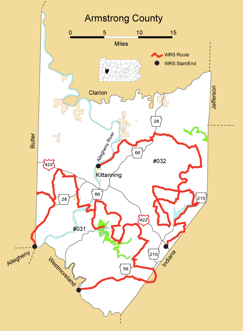
Route#: 031
Route Name: SW Armstrong
Compiler: Mark McConaughy
Directions: Take PA 356 across bridge into Freeport on the southern edge of Armstrong County.
Follow PA 356 out of Freeport and up to PA route 28.
Turn right onto Route 28 and go north to the Slate Lick Exit and make the right onto the exit ramp.
At the end of the exit ramp turn left onto Route 128 and go a short distance into Slate Lick.
Turn left onto SR 3004 in Slate Lick.
Make an immediate right onto SR 3011 (Worthington-Slate Lick Road - but no named road sign at intersection).
Then make an immediate left onto SR 3015 (Winfield Road on my Garmen - no named road sign on road).
Take SR 3015 to the Butler County line. Then turn around at the cement factory just past the Butler County sign and go back into Slate Lick.
In Slate Lick turn left at stop sign onto SR 3011 (Worthington-Slate Lick Road - but no named road sign at intersection). Follow SR 3011 up to US 422 at Worthington.
Turn right onto US 422 at light.
Turn right at next light onto Claypoole Road (SR 3009).
Take Claypoole Road to its intersection with Fox Hollow Road (SR 3002).
Turn left onto Fox Hollow Road (SR 3002).
Take Fox Hollow Road to its end where it intersects with SR 3007 (Glade Run Road - no named road sign at intersection).
Turn right onto SR 3007 (Glade Run Road) and follow it to its intersection with Route 128 .
Turn left onto PA 128 and follow it across the Ford City Veteran's Bridge across the Allegheny River.
Just after crossing the Ford City Veteran's Bridge, turn right onto Ross Avenue.
Take Ross Avenue to Rosston and turn right onto Ross Ctr (that's what is on the road sign), and take it to the Rosston Boat Ramp. Check the Allegheny River for eagles.
Turn around and follow Ross Ctr back out to Ross Avenue and turn right back onto Ross Avenue.
Go up Ross Avenue over the river bluff to US 66.
Turn right onto Route 66 and take it south to Crooked Creek Dam Road.
Turn left onto Crooked Creek Dam Road and go into Crooked Creek State Park. Check for eagles if the lake isn't totally frozen over and look for other raptors around the area.
Get back onto Crooked Creek Dam Road and go back out to Route 66.
Turn right onto Route 66 and go north to Ford City. Turn right onto Bailey Avenue.
Go straight on Bailey Avenue and it becomes Stitt Hollow Road.
Turn right onto Smeltzers Flat Road when the road comes to a T.
Turn right onto Smeltzers Flat Road.
At a Y in the road bear left onto Schall Hollow Road.
Take Schall Hollow Road to SR 2018 (Campbell Run Road).
Take SR 2018 (Campbell Run Road ) to where a left takes you to a bridge over the creek that is on the left side of the road.
Turn left and go over the bridge onto Little Germany Road (according to my Garman - Note: the roads are poorly marked down to Garretts Run Road).
Little Germany Road eventually becomes Campbell Lane.
Campbell Lane eventually runs into Campbell (no Road on sign)(SR 2015?).
Follow Campbell to its intersection on the right with Kerr Road.
Go left at this intersection and it still is call Campbell (SR 2015?).
Take the road to its intersection with SR 2025 (Garretts Run Road )
Turn left onto SR 2025 (Garretts Run Road).
Take SR 2025 (Garretts Run Road) to its intersection Shale Road (T603).
Turn right onto Shale Road (T603).
Take Shale Road to stop sign at its intersection with SR 2020.
Turn right at top sign onto SR 2020 (Pyra Road).
Stay on Route 2020 (Pyra Road) to a stop sign at its intersection with SR 2024.
Turn right onto SR 2024 and follow it to a stop sign at its intersection with SR 2027 (Girty Road).
Turn right onto SR 2027 (Girty Road).
Take SR 2027 (Girty Road) to a T where SR 2026 is a right turn, but SR 2027 goes left.
Go left at the T and stay of SR 2027 (Girty Road).
Follow SR 2027 into Girty where it makes a 90 degree turn to the right and continue to follow SR 2027 (Girty Road).
SR 2027 (Girty Road will cross a bridge over Crooked Creek and end at PA 26.
Turn left onto PA 56.
Take PA 56 east to its intersection with Montgomery Hill Road (TR 692).
Turn right onto Montcomery Hill Road (TR 692) and head toward West Lebanon. You will enter a small
piece of Indiana County at West Lebanon. The hawks seen here are counted with that county's totals.
Turn right onto a short dirt cut off just before going into the village of West Lebanon.
At the stop sign at the end of the cut off, turn right onto SR 3056 and bear right at the next curve.
Follow SR 3056 back into Armstrong County and follow it west to a stop sign at its intersection with PA56/156.
Turn left onto PA 56/156 at the stop sign.
Go straight and follow PA 56 where PA 156 goes off on the left.
Follow PA 56 back into Apollo. Go across the bridge over the Kiskiminitas River into Westmoreland County and the end of the count.
(Note. I sometimes take an alternate route at the last stage as follows -
Turn left off of PA 56 at Garver's Ferry Road. Follow Garver's Ferry Road over to its intersection with PA 66. Turn left onto PA 66 and follow it into Apollo and its intersection with PA 56. Turn right and go across the bridge into Westmoreland Co.).
Route#: 032
Route Name: Armstrong East
Compiler: Margaret Higbee
Directions: Begin at intersection of US 422 and Kimmel School Road (T 667)
Continue on Kimmel School Road. Turn right onto Dutch Run Road (T880)
Follow Dutch Run to Gress Road; turn left; Gress becomes Barks Hill Road (T666)
Turn lft onto Copper Valle Road (SR 2004)
Turn right onto PA 210
Turn left onto Fisher Farm Road (T666)
Turn left onto Sagamore Road (T718)
Turn right onto Sagamore Road (T718)
Turn left onto PA 85
Turn left onto White Oak Farm Road (T690)
Turn right on Ridge Road (T671)
Turn left on Black Road (T688)
Turn right on Reefer Cove Road (T477)
Turn right onto Cessna Run Road (SR 2001)
Continue straight on 2006
Turn left onto SR 2003
Turn left onto Reefer Hollow Road (T678)
Turn right onto Cessna Run Road (SR 2001)
Turn right on SR 2003
Continue straight on Cribbs Road (T375)
Turn right onto Gibson School Road (T668)
Go straight on Upper Cherry Run Road (T670)
Turn left on St. Paul Road (T475)
Turn right on Church Road (T652)
Turn left on SR 2003
Turn right onto Margaret Road (SR 2005)
Turn right on PA 85
Turn left on White Oak Farm Road (T690)
Go straight on Powder House Road (T744)
Turn right on Meadow Road (T579)
Turn left on Sgros Road (T746)
Turn left on Bucktail Road (T747)
Turn right on Bryan Road (SR 1039)
Turn right on Bryan Road (SR 1028)
Stay straight on SR 1041
Turn right on Russell Road (T851)
Continue straight on Mac Road (T547)
Turn left into Dayton (PA 839)
Stay straight on N. State St. in Dayton (SR 1023)
Turn left onto Pasture Road (T764)
Turn right onto SR 1018
Continue straight on SR 1025
Continue straight on Calhoun School Road (SR 1016)
Turn left on PA 28/66
Turn right in Goheenville on Houser Road (T850)
Turn left on Houser Road (T822)
Turn right on Powell Road (T539)
Go left/straight on Houser Road (T850)
Go straight on Adams Road (T693)
Go straight on Mountain Trails Road (T566)
Go straight on Schawl Road (T581)
Turn left on Nichols Road (T689)
Turn left on SR 1031
Go straight on SR 1034
Go straight/left on Johnston Avenue (SR 1033)
End at Kittanning Borough line