Details
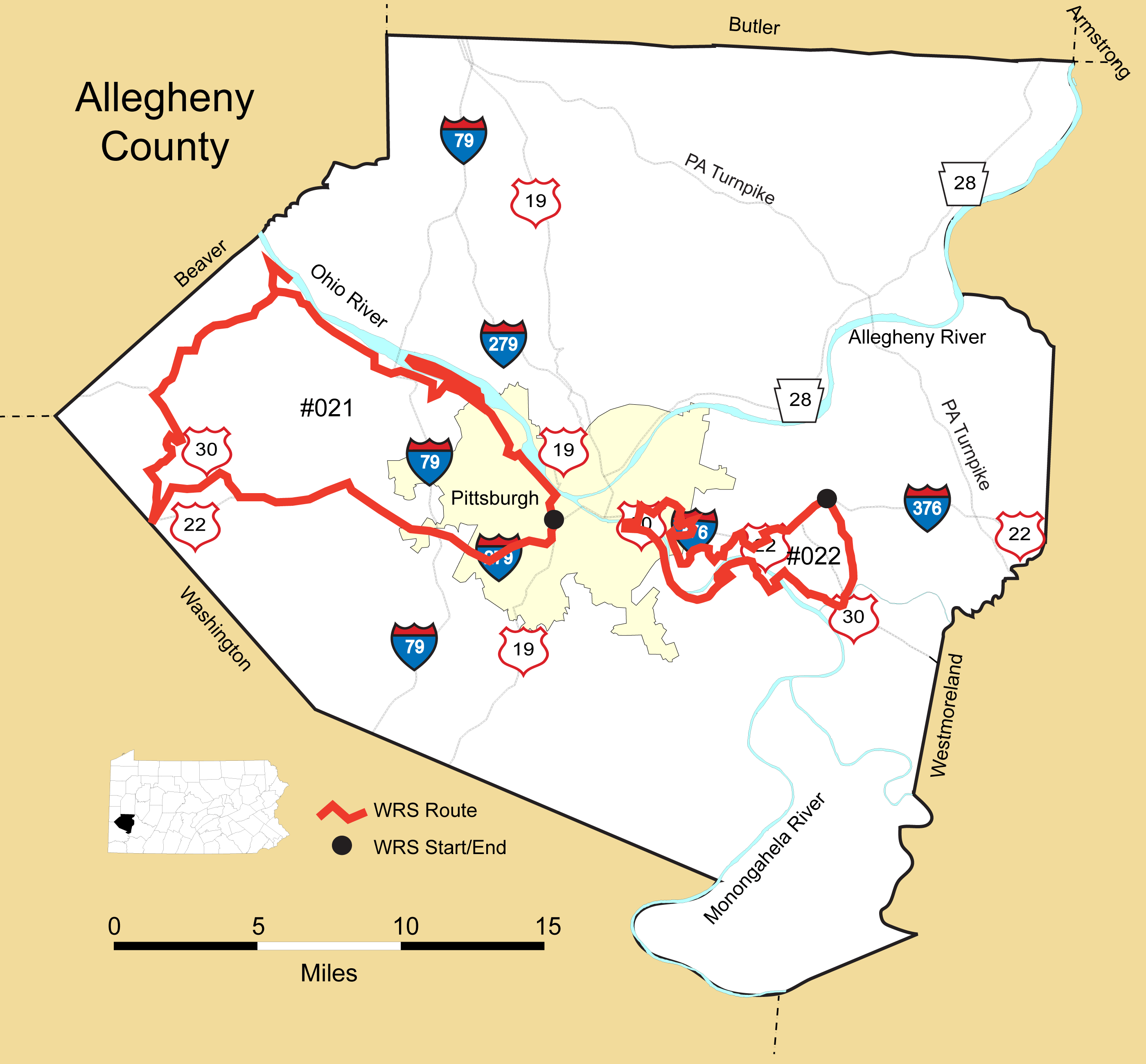
Route#: 021
Route Name: West Allegheny
Compiler: Mike Fialkovich
Directions: Begin at Fort Pitt Tunnel on PA 51 in Pittsburgh.
Continue on PA 51 to the McKees Rocks Boat Dock.
Continue on PA 51 through McKees Rocks and turn right onto Neville Island.
Return to PA 51 in Coraopolis and continue on PA 51 to Flaugherty Run Road.
Turn right onto Flaugherty Run Road and in about two miles turn right into Dashields Dam.
Drive to the parking area near the dam.
Return to Flaugherty Run Road, turn left and take it to Clinton. (Note when nearing the airport, the road gets a little confusing.)
Follow the sign to Clinton after crossing Business PA 60.
The road to Clinton (Flaugherty Run Road) is permanently closed from Business PA 60 to Express PA 60.
At Express PA 60, take the entry ramp to the right (there is a small sign here for Clinton (2 miles) and get on PA 60 South back towards the airport.
Take the first exit and at the end of the ramp, turn right back onto Flaugherty Run Road and follow it to US 30 in Clinton.
At US 30 in Clinton, turn left.
Turn right onto Burgettstown Road and follow it past (now closed) Point Park Road.
Turn left on Potato Garden Run Road and continue to the Truck Stop
Continue into Washington County
Turn right onto Ridge Road and re-enter Allegheny at the Toy Airport to check the fields.
Backtrack to Potato Garden Run Road and turn right onto Boggs road passing the Imperial
Land Fill and the Montour Bike Trail back to US 30 in Imperial.
Turn right onto US 30 and take it to the PA 22/US 30 Interchange.
Take PA 22/US 30 East back to the Fort Pitt Tunnel and the end of the route.
******************************************************************************
Route#: 022
Route Name: Allegheny East
Compiler: Mark VanderVen
Directions: 1) Starting point: Intersection of Beulah Rd. (PA-130) and McCrady Rd., Churchill PA
2) South 3.2 miles on PA-130 (under I 376) to PA-130 and Triboro Expressway
3) South-Southwest on Triboro Expressway 0.5 miles to Triboro Expressway and Electric Avenue (East Pittsburgh PA)
4) Continue on same road 4 miles (now Braddock Avenue) South-Southwest then West Northwest to Rankin Bridge (Rankin PA)
5) South across Rankin Bridge (to Whitaker PA / River Road)
6) West on River Rd 0.7 miles to East Waterfront Drive (Munhall PA)
7) North over rails and 2.4 miles along East Waterfront Drive (overall westerly direction) to W. 5th Avenue (by Costco)
8) Double back eastward on W. 5th Avenue 0.8 miles to West Street.
9) Right (south) on West Street 2-3 short blocks to W. 8th Avenue.
10) Right (westward) on W. 8th (PA 837). Continue 1.6 miles on W. 8th/W.7th to interchange at intersection of PA 885 and 837.
11) Take interchange ramp to E. Carson Street (continuation of PA 837 in general westward direction) to S. 18th Street/E. Carson St. intersection
12) North (0.5 miles) on S. 18th Street to Wright Way. Short right (east) on Wright Way. Turn around under bridge and return to S. 18th Street and E. Carson tracing same route
13) East (0.4 miles) on East Carson to base of Birmingham Bridge.
14) Left (north) on Birmingham Bridge and cross.
15) Follow signs to Oakland/Forbes Avenue, staying to right on bridge.
16) In general East-northeast direction take Forbes 1.2 miles to Schenley Drive catty-corner from Cathedral of Learning (gothic skyscraper). Careful : Forbes reintersects with Schenley Drive much farther on).
17) Right (South-southeast) 0.8 miles on Schenley Drive (becoming Panther Hollow Road at intersection - careful NOT to go left on Schenley Drive at intersection w/ Panther Hollow Road – stay on Panther Hollow Road and cross bridge!)
18) Nearing Boulevard of the Allies continue STRAIGHT through interchange, making sure NOT to bear right towards downtown. Go under Boulevard of Allies near Schenley Park swimming pool to Overlook Drive.
19) Winding southerly course then abruptly shifting northeast on Overlook Drive for a little over 1 mile to Overlook Drive and Greenfield Avenue.
20) South on Greenfield Ave (through Schenley Park then over I-376 on bridge, then turning sharply right / westerly), remaining on Greenfield Ave. After 1.4 miles, come to Greenfield Ave and Second Avenue.
21) 0.2 miles northwest on Second Avenue to Blair Street.
22) 1.3 miles generally south on Blair Street (parallel to river) to Hazelwood Avenue
23) 0.25 miles (make left) on Hazelwood Avenue to Second Avenue
24) 0.3 miles south (make right) on Second Avenue to Johnston Avenue
25) 1.7 miles on Johnston Avenue (becoming Desdemona Ave briefly, then, becoming
Imogene Rd).
26) Make right (south on Browns Hill Rd.) 0.2 miles. Stay to left!
27) Make left on Parkview Boulvard and a very quick right onto Old Browns Hill Rd. Make immediate right (first right) onto Garetta St. and do loop around Riverview Homes/Jewish Association on Aging grounds.
28) Return to Old Browns Hill Road and make a right, going northeast then southeast and under railroad trestle till reaching DUCK HOLLOW. Survey from Duck Hollow parking lot then retrace route up to Parkview Boulevard.
29) Proceed northeast one mile on Parkview Boulevard to intersection of Parkview and
Summerset Drive.
30) 0.25 miles north on Summerset to Forward Avenue and make a left.
31) 1.1 miles on very winding Forward Avenue (which becomes Commercial) down through Frick Park, under I-376 bridge, and up Commercial till intersection with Blackhawk St.
32) Left/East on Blackhawk in general eastward direction to S. Braddock for 0.7 miles : Blackhawk to Nevada, very short left. Quick right onto Harrison. Right onto Oak Grove/Aurelia. Left on Schoyer Avenue until S. Braddock.
33) Left/North onto S. Braddock for 0.25 miles. Stay to right and get onto I - 376 towards MONROEVILLE.
34) 3.1 miles going west on I-376 to Churchill Exit. Get off at Churchill Exit to finish route.
******************************************************************************