| Crawford |
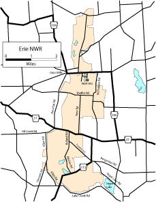
| DESCRIPTION: Established in 1959, the Erie National Wildlife Refuge covers 4,961 acres and lies in a narrow valley which runs north and south. Woodcock Creek flows north out of the refuge. Lake Creek flows south and when it leaves the refuge empties into Sugar Lake, a deep water lake left by the glaciers. Habitats include upland fields, hardwood forests, mixed hardwood and coniferous forests, ponds, stream bottoms, and swamps. These varied habitats make for interesting birding, especially in the summer. From mid-May to the end of July a calm, warm, sunny morning will net a good collection of birds. During migration almost anything can show up. Winter is another interesting season. In the last twenty years, Pine Grosbeak, both crossbills, Common Redpoll, and Snowy Owl have been sighted. A map of the refuge and advice about which areas are open to the public (these change with the calendar) can be obtained at the headquarters. There is also a 1-mile nature trail near the headquarters that makes a good start on the day's birding. Along the route you can do all the birding from the road, but if you wish, you may walk down any woods road unless entry is prohibited. |
DIRECTIONS: From the intersection of PA 77 and PA 27 in Meadville, go east on PA 27 for 5.9 miles. The road makes a sharp right, but instead go straight on Guys Mills Road. Proceed for 2.8 miles to the intersection with PA 198. Go straight (east) on PA 198 for 0.7 mile and turn into the Refuge Headquarters on the right. The following route will provide a good sampling of the refuge, but there are other roads and trails worth exploring. From the Headquarters, go east on PA 198, 0.4 mile and turn right (south) on McFadden Road. Go 1.65 miles (past Shaffer Road) and check the ponds on the left (east). Turn around and go back up to Shaffer Road and turn left (west). From the intersection, go 0.9 mile to the stream crossing and check the wetlands here. Turn around, go east on Shaffer Road for 0.3 mile and turn right (south) on New Road. At 0.2 mile stop at the stream crossing. Continue south 0.9 mile and check the pond on the east side of the road. Then go another 0.1 mile or so and walk back the road on the west side of the road (if open to the public). This leads back to a wetland. Continue south to the T intersection and turn right (west) on PA 27. Go 0.4 mile and turn left (south) on Boland Road. At the intersection with Fowler Road (0.4 mile) check the fields on the west. Continue south on Richie Road 0.7 mile to a pond on the east and a road on the west (if open). Continue another 0.6 mile to the intersection with PA 173 and a large wetland on the west. Turn right (west) on PA 173 and go 0.5 mile to the stream crossing. Continue south for 0.25 mile and turn left (east) on Lake Creek Road. Go 0.7 mile to a large wetland on the north. Then continue east for 1.45 miles to Sugar Lake. Continue on Lake Creek Road another 0.75 mile and turn left (north) on Sugar Lake Road. Go 1 mile and stop for another view of the lake. Go 1 mile and turn west on Bogardus Road to PA 173 for the end of this tour. This route may be adequately covered in a half day. |
|
Maps - other than Google (Click on map for larger view)
|
|
Sub-sites |
Photos |
| Posted: 2009-10-24 00:00:00 Updated: |