| York |
| DESCRIPTION: Brunner Island is on the west bank of the Susquehanna River in York County, about 15 miles downstream of Harrisburg. It is mostly open fields and grasslands, but contains a bird-rich wetlands and several good stands of mature trees. Regular birds: Any bird likely to be seen in or along the Susquehanna river can be found here in season. The ponds produce migrating songbirds, shorebirds, waterfowl, and long-legged waders as well as nesting Wood Duck and Orchard and Baltimore orioles. Prothonotary Warbler and other woodland species, including Wild Turkey and Pileated Woodpecker, can be found along Gut Road. |
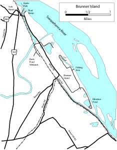
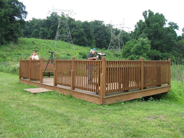
DIRECTIONS: From I83, take Exit 32 (Newberrytown). Take PA 382 east into York Haven. At the intersection of PA 181, go straight for one block (do NOT take Route 181). Bear right onto Locust Street and take this across the railroad tracks. The road is now named Wago Road. The first left after the railroad tracks will take you into Hydro Park. Hydro Park is a community park set on the premises of the York Haven Hydro Station powerplant. (York Haven Power Company owned by Olympus Power) There is a boat launch there. Public porta-potties on site. Start by walking out onto the catwalk (don't miss this exhilarating experience as you feel the rumble of the turbines beneath your feet and the smell of the jet-thrust discharge spray) on the east face of the plant to get a great look at the Susquehanna River. You have to walk through a maize of chainlink fences to get out onto the on-the-river catwalk. The deck is an iron grate which allows you to look straight down into the water. It is open to the public even though you have to practically feel your way as if blindfolded to find it. You are likely to encounter fishermen on the catwalk over the water discharge area. You may expect to see geese, ducks, gulls, herons, cormorants, etc. from the catwalk. Great numbers of Northern Rough-winged Swallow nest in holes in the irregular east face of the stone-sided building. Flocks may be seen circling over the river. Walk back to the community park. From here you may see Osprey, which nest at the top of the plant. Normal park songbirds may be found there, such as Chimney Swift, swallows, Eastern Phoebe, etc. If you need more gulls, a walk to the back of the park will give you a better view of the west side of the river and reservoir that is obstructed from the catwalk. A scope is required. Return to Wago Road and turn left over the concrete bridge. This puts you on Brunner Island, owned by the Pennsylvania Power & Light Company. Take the very first left (less than 0.1 mile) and go down to the Conowago boat ramp. During the dry months, you will find a concrete boat ramp at the end of a stony peninsula that extends about 50 yards into the river. On a good day you may pick up a few shore birds on this peninsula. The trees on shore hold the usual songbirds as you would expect. Not much different than the Hydro Park. Various waterfowl can be found in the creek. Go back to Wago Road, turn left and proceed another 0.1 mile. Turn left into Hibiscus Trail. This meanders from an open field habitat into a stand of mature trees. (NOTE: There is currently construction occurring in the immediate area and it looks as if the trail has not been maintained.) There are many American Kestrel nest boxes at several locations on the island. Prothonotary Warblers nest in the swampy area and Blue Grosbeak can be found in the open areas. Back on Wago Road, go left approximately another 0.2 mile. Turn right (opposite the main powerplant entrance) onto a dirt road. Follow it around to the Duck Pond Wetland Area. (Clean, large porta-potties are available.) The wetlands is a series of five man-made ponds that are encircled by connected trails. Red-winged Blackbird are everywhere and this is a good spot for Orchard and Baltimore orioles, Field (and other) Sparrow, swallows, Eastern Bluebird, Northern Mockingbird, Willow Flycatchers, Blue Grosbeak, Brown Thrasher, Yellow Warbler, Prothonotary Warbler, shorebirds (when water levels are low), woodpeckers, etc. On the ponds proper you may find herons, egrets, ducks (especially Wood Duck), Eastern Phoebe, and turtles galore. NOTE: The Wetlands may be closed on weekends and holidays. Return back to Wago Road. Turn right and drive slowly past the pond on your right about 0.1 mile down the road. The trees serve as good perches for hawks, etc. Continue straight down Wago Road. Stay straight at the big right-bend (where Wago Road leaves the island), and continue straight along the service road parallel to the railroad tracks, until the road forces you to make a sharp left. Proceed about 0.1 mile until you come to a Y in the road just in front of the huge transmission tower which carries the lines over to Haldeman Island. Bear right at the Y and park right along the wide shoulder. You will have a good elevated look at a second-growth habitat on your left from this spot. This area is good for finches, Yellow Warbler, Common Yellowthroat, and in season, several species of sparrows flit around in the grasses and saplings. If the gate is open, you may proceed south along this dirt road until you get near the end. There you will find a large filtration pond that is good for assorted ducks, geese, and swans. Several American Kestrel nesting boxes are on the west side of this pond. NOTE: This area is closed on weekends and is hit-or-miss during the week. Turn around and return to the Y at the Haldeman tower. Bear right at the Y and turn right into any or all of the various river/fishing pullouts. This heavily treed area along the river can yield a good variety of songbirds. A short walk out to the river may yield more water birds. The roadside in this area is usually full of Gray Catbird, Orchard and Baltimore orioles, American Goldfinch, sparrows, chickadees, titmice, vireos, etc. Continue down to the main fishing area. (Porta-potty available.) You can walk out to the shore and look all the way up the tailrace. Belted Kingfisher, both orioles, herons, gulls, ducks, etc. may be found either on the river or up the tailrace. You can continue further along this road if you wish. If you need more waterfowl, there are a few additional ponds along the entrance road to the main gate, which you passed on your way to the wetlands. A side trip to Gut Road can yield Prothonotary Warbler and other woodland and swampy habitat species. Gut Road is a dirt road that runs for a couple of miles along a slow moving, wooded stream that occasionally spreads out to form swampy areas. To get to Gut Road from the power plant, go south on Wago Road. Wago Road bends to the right as you leave the island and passes under a railroad bridge. Just before the bridge, Gut Road goes off to the left. |
|
Maps - other than Google (Click on map for larger view)
|
|
Sub-sites |
Photos 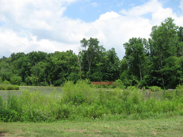
|
| Posted: 2009-10-24 00:00:00 Updated: 2009-11-20 00:00:00 |