| Washington |
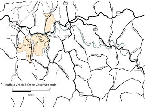
| DESCRIPTION: This Important Bird Area is approximately 5000 acres in the middle of the Buffalo Creek watershed. There are no named trails in the area, though there are many places to explore by car and foot. The water in Buffalo Creek and it's tributaries is rated high quality and Louisiana Waterthrush are abundant. There are two active Great Blue Heron rookeries, one of which is visible from Lake Road. The mature second growth forest along streams such as Buck Run Road (T-376) are great places to find breeding neo-tropical migrants, including Cerulean and Yellow-throated warblers, American Redstarts, Acadian flycatchers, vireos, Scarlet tanagers, Rose Breasted Grosbeaks and orioles. Buffalo Camp Road, (closed to cars), which follows Buffalo Creek, is a nice walk that starts at a restored covered bridge on PA 221, and has a variety of habitats and bird species. The grassland and shrubland areas along SR-4024 and T-541 have many sparrows, Yellow-Breasted Chats, Blue-Winged Warblers, and Bobolinks. Early Spring and Fall bring many migrants including waterfowl and shorebirds to the three main wetlands. The wetland on Greencove Road just off of PA 221 is the largest with a walking path around it for viewing. |
DIRECTIONS: Note: most of the roads in this area do not have street signs, so note the Township (T) and State Road (SR) designations below. From exit 11 of I-70, take PA 221 north 3.3 miles to Taylorstown, where PA 221 makes a 90-degree right turn. From here continue on PA 221 another 2.5 miles and turn right on Green Cove Road SR 4061). Go 0.2 mile to the parking area on the right for the Green Cove Wetlands. Return to PA 221 and turn right (north) and go 0.7 mile and turn left (west) on Pole Cat Hollow Road (T 427) to the Sawhill Covered Bridge. Park here and walk the closed road to the west and north along Buffalo Creek. The first section is along Pole Cat Hollow Road. At 0.2 mile, go right on Buffalo Camp Road. This road follows Buffalo Creek for 2.5 miles and ends at PA 231 near Acheson. From PA 221 and Pole Cat Hollow Road, continue north of PA 221 for 2.7 miles to PA 231. Go left (south) on PA 231 for 0.3 mile and turn left (east) on Buck Run Road (T 376). Immediately on the left is the northern end of Buffalo Camp Road. Walk down Buffalo Camp Road a short way to check out the wetlands on the south side of the road. Go back to PA 231 and go left (south) for 0.2 mile to an unnamed dirt road to the right. Park here and walk back this road about 0.25 mile to get to another wetlands area. Continue south on PA 231 for another 1.8miles and bear left on Ramage Road (T 541). Follow this road for 1.5 miles to Buck Run Road (T 376), watching for field and edge species. Turn right (south) and go 2.1 miles to PA 231 and turn left (east). Go 0.4 mile and turn left on Claysville/Taylorstown Ridge Road (SR 4024). This returns to Taylorstown in 4 miles. Watch for field and edge species along this stretch. SGL 232, in the western portion of this area, is mostly forested, but has open food plots as well. |
|
Maps - other than Google (Click on map for larger view)
|
|
Sub-sites |
Photos |
| Posted: 2009-10-24 00:00:00 Updated: |