| Tioga |
| DESCRIPTION: Cowanesque Lake, along Pennsylvania's northern border, is a magnificent area to bird for inland water birds, raptors, warblers, and more. This lake can be readily enjoyed by kayak or canoe. Its 1,085 acres of water were impounded for flood control purposes by the USACE as a response to the 1972 flood caused by Hurricane Agnes. |
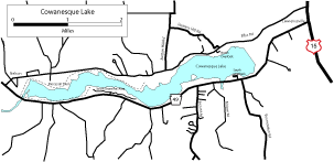
DIRECTIONS: From the US 6/PA 287 junction drive PA 287 north 14 miles to a stop sign in the village of Tioga. Turn left to continue on PA 287, which shortly changes to US 15. Follow US 15 north another 8 miles to the village of Lawrenceville. Turn left (west) onto PA 49 to Cowanesque Lake. The following route takes you on a 16-mile loop around the Lake and brings you back out to US 15, just 3.5 miles north of the PA 49/US15 intersection. All mileage around the loop is based from this Lawrenceville intersection. From this intersection in Lawrenceville, go 0.5 miles on PA 49 west to Weaver Street to see a Bald Eagle nest. Look north, across the field. The nest is in a white pine almost in the center of the mountain. New US 15 is being constructed at this time, quite near the nest, and it's possible this nest will become abandoned. Note: upon completion of the construction, the US 15 designation will be changed to I-99. At 1.3 miles from the Lawrenceville intersection, a maintenance road on the right leads to an Osprey nest and some creek-side birding. There are at least five known active Opsrey nests on or around Cowanesque Lake, this being the first. At 1.7 miles you will see Cowanesque Lake on your right. There are many good places to pull off the road and view gulls (mostly Ring-billed), geese, and ducks. Bald Eagle and Osprey can frequently be seen fishing and soaring down the lake. Common Loon, Brant, Tundra Swan, Snow Geese, and Great Egret have been seen here during migration. The entrance to the South Overlook is at 2.2 miles. Pull in for views of more Osprey nests and several species of warblers. Continuing down PA 49, at 2.7 miles, you will arrive at Erickson Road on the left. Take a short detour up this road for good grassland birding (Bobolink, Eastern Meadowlark, Field Sparrow, and Eastern Bluebird. Wild Turkey and Ruffed Grouse have been recorded here also. Another productive detour is at 3.0 miles down PA 49, at Birch Hill Road. A second Bald Eagle nest may be seen from this intersection by looking across the lake. Taking this left on to Birch Hill Road for 1.5 miles or so often produces a wide variety of woodland warblers: Black-throated Blue, Black-throated Green, Black-and-white, and Ovenbird. Scarlet Tanager, Yellow-billed Cuckoo, Wild Turkey, Ruffed Grouse, and Pileated Woodpecker as well as Black Bear, White-tailed Deer, and Bobcat have been sighted here also. The South Shore Recreational area is at 5.1 miles. Turning right at this entrance leads you to a T with choice of left to the boat ramps (gull, ducks, herons, kingfisher) or right to the swimming area. Either way, trees line the parking lot and lake where many species of flycatcher, vireo, warbler including Black-and-white, Chestnut-sided, Yellow, Common Yellowthroat, and American Redstart, have been seen, as well as Killdeer in the lot itself. Note: park only in designated parking areas in these recreational areas, not on the grass! Continuing down PA 49, at 5.9 miles pull over to the side of the road. Protruding from the lake are many stumps, excellent perching spots for Osprey, gulls, herons (Great Blue and Green), and, during migration, Great Egret and Double-crested Cormorant. The cormorants are being monitored for possible breeding in this area, so any report of your findings during breeding season would be appreciated. Three Osprey nests have been documented on these stumps. Continuing your loop around the Lake, at 7.3 miles turn to the right toward the village of Nelson. The Mocassin Trail is at 8.2 miles with a second access at 9.9 miles. This is a beautiful trail on which a Blue-winged Warbler has been sighted, along with many other warblers, woodpeckers, and flycatchers. At 10.8 miles the Tompkin Campground appears on your right and Button Hill Road on your left. Button Hill Road is a 2.3 mile loop into grasslands, where Eastern Bluebird, Indigo Bunting, Northern Flicker, Red-bellied Woodpecker, Pileated Woodpecker, Yellow-bellied Sapsucker, Rose-breasted Grossbeak, Great Crested Flycatcher, American Kestrel, Northern Mockingbird, Ruffed Grouse, Red-tailed Hawk, many species of swallows, grassland birds such as Bobolink and Eastern Meadowlark, and a Nashville Warbler have been documented. At a right curve on Button Hill Road, the name changes to Heater Hill Road. As you access the highway again, you will have traveled l.3 miles from the Tompkins Campground/Button Hill intersection. This next section will be very wooded and again full of woodland species, including Eastern Wood-Pewee. Note that the street name on this side of the lake is Bliss Road. There is a cutback on the 1.3 mile section of the highway that you'll miss if you take the Button Hill loop. On this cutback, Bank and Rough-winged swallows have been seen on the electric lines, but you will have to retrace this section of road to find them. At 12.0 miles on this loop around Cowanesque Lake, you will find the entrance to North Overlook. Yellow-rumped and Yellow warblers have been seen here. A right at mile 13.0 will lead you to a dirt road on the lower side of the dam. You can see a wooded area down this road at the base of the dam, a good place for flycatchers. If you just pull into this road and stop, look to the west. In the tree line on the floor of the valley there is a 24 nest Great Blue Heron rookery (much more easily seen in fall when the leaves are scarce!) You are now just 3.5 miles from the end of the loop where you will be joining up again with US 15. |
|
Maps - other than Google (Click on map for larger view)
|
|
Sub-sites |
Photos |
| Posted: 2009-10-24 00:00:00 Updated: |