| Somerset |
| DESCRIPTION: Mount Davis is the highest point in Pennsylvania. The area contains a public PFBC lake (High Point Lake) and a good size lake at the Deer valley YMCA camp. Both are worth checking for waterfowl and loons in migration. Bald Eagle are seen at High Point Lake more than any other place in the county away from the Allegheny Front migration corridor. The real beauty of Mt Davis is its nesting birds and their accessibility. The high elevations of Forbes State Forest have many species more commonly found further north. Warblers abound. Black-throated Green, Black-throated Blue, Canada, Black-and-white, Blackburnian, Magnolia, Chestnut-sided, Northern Parula, and Hooded are all found along the rough gravel roads. Golden-crowned Kinglet, Winter Wren, Blue-headed Vireo, and Dark-eyed Junco all breed. Hermit Thrush, Wood Thrush, and Veery may all be heard from one spot. Boggy areas can yield Willow or Alder Flycatchers. Northern Saw-whet and Barred owls are regular breeders, and Whip-poor-will are often heard at night. |
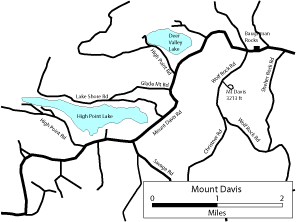
DIRECTIONS: From downtown Meyersdale on US 219B go west on Broadway for 0.85 mile and bear right on Mount Davis Road (SR 2004). Follow this road through the town of Summit Mills and then through some nice farmland for 4.7 miles where it turns right (west). From here drive 1.5 miles to St. Paul Road and stay to the right on Mount Davis Road. Watch this area for Horned Lark, Bobolink, etc. Continue on Mt. Davis Road about 2.3 miles to the top of Mt Davis and a picnic area on the left. Across from and slightly west of the picnic area is a small parking lot and a short trail at Baugham Rocks. This area is good for warblers such as Canada, Hooded, Black-throated Blue, Black-throated Green, and Black-and-white, as well as Dark-eyed Junco. A road on the left of Mt Davis Road ((with signs) leads to the highest point in Pennsylvania at 3,213 feet with a parking lot, viewing tower, and short trails. Other gravel roads on the top such as Wolf Rock Road and Shelter Rock Road can be explored for thrushes, warblers, vireos (Northern Saw-whet Owl, Barred Owl, and Whip-Poor-Will at night) before returning to Mt. Davis Road and heading west again. Descending slightly for 1.3 miles brings you to Deer Valley YMCA Camp and Deer Valley Lake on the right. The spruces at the entrance to the camp are good for Blackburnian and Magnolia warblers. The lake is seen from the road just beyond the entrance. Two miles beyond Deer Valley is High Point Lake on the right side. The lake and surrounding forest can be explored on the north side from Lake Shore Road which branches to the right and the south side by proceeding on Mt Davis Road along the south side of the lake. Surrounding fields can be viewed from the road or from the access road to the boat launch. |
|
Maps - other than Google (Click on map for larger view)
|
|
Sub-sites |
Photos |
| Posted: 2009-10-24 00:00:00 Updated: |