| Schuylkill |
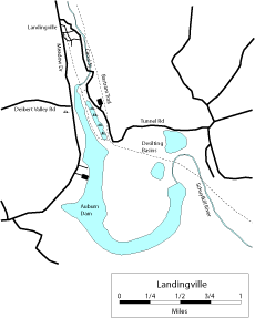
| DESCRIPTION: The Landingville area is one of Schuylkill County's best birding locations, currently with a species list of 211 birds, of which 77 have been found breeding in recent years. The best birding locations include Bartram Trail, Auburn Dam, Landingville Marsh, and the desilting basins. The newly refurbished Bartram Trail runs parallel with the Schuylkill River and the Landingville Marsh, beginning at the entrance in Landingville and currently ending at the desilting basin area. A parking area is located across from the midway point of the marsh. In addition to the Bartram Trail, a walking path circumvents the entire marsh area, enabling birders to get excellent views of herons, egrets, and occasional rails. It is not uncommon to see Bald Eagles and Ospreys fishing at the dam and marsh, and 22 species of ducks have been recorded. The desilting basin is home to the county's largest Bank Swallow colony, with at times well over 100 birds. |
DIRECTIONS: From PA 61 and PA 895 in Deer Lake, go north on PA 61 for 3.3 miles and turn left onto Adamsdale Road (two roads go left at this point, Adamsdale Road is the second (westernmost) one). Continue 0.9 mile and turn left (south) on Meadow Drive. Go 0.8 mile and turn left on Canal Street. Go through the park, along the river, and over the one-lane bridge 0.9 mile to the parking area on the left. Canal Street becomes Tunnel Road south of this point. Bartram Trail goes both ways from the parking area, either south towards the desilting basin alongside the marsh, or north towards the Landingville ballpark alongside the river. The trail at this point is on the east side of the road, but crosses over just south of the parking lot and follows the east side of the marsh. You can walk entirely around the marsh by getting off the Bartram Trail at the southern end of the marsh and circling to the right. This trail rejoins Canal Street just south of the bridge mentioned above. This loop is about 1 mile. If you continue south on the Bartram Trail another 0.5 mile instead of looping around the marsh, you will come to the desilting basin, which has a large colony of Bank Swallows. This can also be viewed from Canal Street 0.4 mile south of the parking lot. Return to Landingville on Canal Street, and turn left at the ballpark onto Meadow Drive. Continue for 0.6 mile to the intersection with Deibert's Valley Road. Turn right and pull into the pull-off immediately on the left. There is a small marsh on the southwest corner of this intersection worth checking. Across Meadow Drive, you can climb over the guardrails for a view of the river entering the lake. This can be good for shorebirds if the water is low. Continue 1.2 miles south on Meadow Drive to the entrance for the dam area on the left. There are two roads. The first goes to a small parking area used by fishermen. The other goes to the boat launching area. Both should be checked for slightly different views of the lake. |
|
Maps - other than Google (Click on map for larger view)
|
|
Sub-sites |
Photos |
| Posted: 2009-10-24 00:00:00 Updated: |