| Mercer |
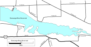
| DESCRIPTION: When (if) lake levels drop in late summer, this reservoir has extensive mudflats which are very good for migrant shorebirds. The mudflats are only exposed when the water level is below 894.5 feet. The current and forecast reservoir levels for Shenango can be obtained at the following website: http://waterdata.usgs.gov/pa/nwis/uv/?site_no=03103400. At 894 feet, West River Road will have habitat, and as the level drops lower than that, mudflats will appear at the other two locations. |
DIRECTIONS: From PA 18/PA 258 (about 4 miles northeast of Sharon), go east on PA 258 for 3 miles and turn left (north) on an unnamed road marked by a sign that says "Golden Run Wildlife Area". Go 0.5 mile to the T and turn right (east) and go 0.3 mile to the end of the road and a parking area on the left. As you approach the road's end, an active Osprey nest platform will be visible dead ahead, at the base of which there may be shorebird habitat. Check here for shorebirds and walk the short trail that heads north from the parking area for a view of the lake and shorebird flats, if any. Return to PA 258 and turn left (east) and go 1.3 miles and turn right (south) on Charlestown Road and park here. Walk back to PA 258, turn right and go 0.1 mile to an overgrown road (known to birders as"Willow Tree Road") on the left. Follow this road down to the shoreline (about 1/3 mile) to view more mudflats. Return to your car and continue east on PA-258 for 0.9 mile and turn left on West River Road (which is paved at the intersection but quickly becomes a dirt road). Go about 0.5 mile and look for a wide area on the left side of the road at the beginning of a wire guardrail. There is a trail that enters the woods at this spot, which you can follow down to the lake and mudflats. Mud boots are highly advisable at West River Road and Willow Tree. |
|
Maps - other than Google (Click on map for larger view)
|
|
Sub-sites |
Photos |
| Posted: 2009-10-24 00:00:00 Updated: |