| Lawrence |
| DESCRIPTION: This agricultural area was strip-mined for coal in the late 1980s and by 1990 this reclaimed area was already the summer home for Bobolink and Eastern Meadowlark along with Vesper, Grasshopper, Savannah, and Field sparrows. By 1992 Henslow's Sparrows were nesting at the strips. Short-eared Owl and Dickcissel have nested there. Clay-colored Sparrow and Sedge Wren have appeared at the strips. Upland Sandpiper have been noted as moving through in spring and late summer. Rough-legged Hawk have been recorded there most winters and Northern Harrier have been seen flying with Short-eared Owl. There are also ponds that attract migrant waterfowl. |
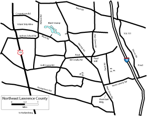
DIRECTIONS: The Volant Strip Mine Area is in Washington Township in the northeast corner of Lawrence County. To get to the "Volant Strips", start at Harlansburg at the intersection of US 19 and PA 108. Go north on US 19 for 5.2 miles and turn right (east) onto Jackson School Road. The area is bounded by US 19 on the west, Jackson School Road on the south, Nelson Road on the east, and Cooperstown Road on the north. Black Road runs through the middle of the area. Drive all of these roads to view the area. The Volant Strips is on private property and runs along US 19 for over a mile and it is about a mile or so in depth. A small humus factory sits at the edge of the strip mine and a few homes dot the landscape. Black Swamp (SGL 284) is just east of the Volant Strips so most birders take Black Road east for another 0.5 mile past Nelson Road and turn left at the first dirt road past the pines into the parking lot. Some of the wetland and waterfowl can be seen from the parking lot but most birders take a scope and walk 5 minutes into the woods for better views of waterfowl or perhaps shorebirds. You may see or hear Virginia Rail, Sora, or Common Moorhen. Listen or watch for Wilson's Snipe winnowing flight displays in April and May. To view the entire back-end of Black Swamp, continue traveling east on Black Road for 0.8 mile and turn left on Old Ash Road and go less than 0.2 mile and turn left into a parking area. This is private property, but birders are permitted. Scan the ponds from here. During migration, you will need your scope to identify the hundreds of birds on the water. |
|
Maps - other than Google (Click on map for larger view)
|
|
Sub-sites |
Photos |
| Posted: 2009-10-24 00:00:00 Updated: |