| Lawrence |
| DESCRIPTION: Sandhill Cranes have been nesting in Lawrence County since 1993. This is the best area to see them. |
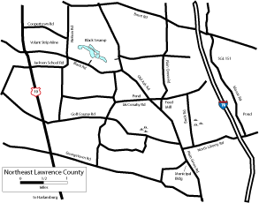
DIRECTIONS: Take US 19 North out of Harlansburg for 3.9 miles to Green Meadows Golf Course and turn right (east) onto Golf Course Road. Go down Golf Course Road for 2.2 miles to the wetland on the left (north) where a pair of Sandhill Crane nested in 2004. Beavers built a dam on private property at Taylor Run and the water flooded the farmer's pasture. Years later the dam broke and the water receded and now there is not a lot of open water left, but Taylor Run still flows through the cattails and other tall grasses far from the road. You may want to use a scope for better views. At times there are good shorebird numbers here and 30+- Sandhill Crane have gathered here before leaving to nest at other locations. This is one of several locations in Plain Grove Township to watch and listen to Wilson's Snipe winnowing flight displays in April and May. Continue east on Golf Course Road for 0.9 mile to Plain Grove Road. Turn right (south) and go 0.35 mile and look for cranes across from the Municipal Building. Red-headed Woodpecker can also be seen there. Red-headed Woodpecker are also near the Feed Mill on Plain Grove Road, which is 1 mile north of Golf Course Road on Plain Grove Road. Cranes have also been seen on Mason Road at the edge of SGL 151. This used to be a Sand and Gravel operation but they are no longer mining and the strip mine lake is a great place to bird for waterfowl and nice close-up looks of Bank Swallow nesting. To get here, from the intersection of Golf Course Road and Plain Grove Road, go south on Plain Grove Road for 0.1 mile and turn left (east) on North Liberty Road. Go 1.3 miles and turn left (north) on Mason Road. Continue 0.5 mile to the ponds on the right. SGL 151 is about another mile north. There is a nice little wetland along Book Road where Sora can sometimes be heard and seen and Virginia Rail have walked across the footpath of the trail going into SGL 151. From the intersection of Golf Course Road and Plain Grove Road, go south on Plain Grove Road for 0.1 mile and turn left (east) on North Liberty Road. Go 0.25 mile and turn left (north) on Book Road. Continue 0.45 mile to the wetland on the right (east). A pond on McConahy Road is loaded with waterfowl during migration. From the intersection of Golf Course Road and Plain Grove Road, go north on Plain Grove Road 0.8 mile and bear left on Old Ash Road. Go 0.4 mile and turn left (west) on McConahy Road and go 0.3 mile to the pond on the right. Another crane area is Bonanni Road. From the intersection of Old Ash Road and McConahy Road go north on Old Ash Road for 1.2 miles and turn right (east) on Bonanni Road. Look for cranes from here to the intersection with Plain Grove Road. |
|
Maps - other than Google (Click on map for larger view)
|
|
Sub-sites |
Photos |
| Posted: 2009-10-24 00:00:00 Updated: |