| Beaver |
| DESCRIPTION: SGL 285 in the northwestern section of Beaver County features a diverse array of habitats and supports an impressive bird list. |
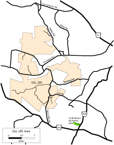
DIRECTIONS: A good starting point for a tour of the area is the intersection of PA 168 and PA 251. Begin by heading north on PA 168 for 0.3 miles to South Beaver Recreation Park on the left. The gate may be closed in the very early morning, but you can park outside the gate and walk in, or drive in if the gate is open. Proceed all the way to the end and park in a grass and dirt parking area. There are extensive shrublands and grasslands to the north that can be explored by foot, which feature Yellow-breasted Chat, Henslow's and Grasshopper sparrows, and Orchard Oriole in spring and summer, among many others. Return to the intersection of PA 168 and 251, and head west (right) on PA 251 for 1.2 miles to Watts Mills Road, and turn right. Fields on either side of Watts Mills Road here support American Woodcock and Henslow's Sparrow and a host of other grassland species. Continuing north of these fields the road winds through heavy woods including an extensive pine plantation that is good for species characteristic of those habitats. Watts Mills Road is also excellent for night birding, particularly Whip-poor-will; this is the best location in Beaver County to find this species, generally from mid-May to the end of June. One mile north of the intersection of Watts Mills Road and PA 251 is a gamelands parking lot on the left, from which a trail begins and travels generally east all the way to the Ohio State Line through extensive unbroken woods. This trail is excellent for a number of locally uncommon species including Black-and-white Warbler and Ruffed Grouse. There is also a short trail on the opposite side of the road from this parking area that goes steeply uphill for a short way to a successive shrubland area that supports the county's best population of Prairie Warbler, in addition to other shrubland specialists. Throughout this area (especially on the west side of Watts Mills Road), you can wander freely off the trails, which is difficult in some places, but worthwhile. A GPS unit can be very helpful if you wander well off the beaten path. There are a few other hikes nearby worthy of mentioning. Continue north for less than 0.1 mile on Watts Mills Road from the parking area to the intersection with Cole Road. At this corner another gamelands trail heads into the mixed pine/deciduous woodlands that can be productive. Continuing north on Watts Mills Road from the intersection of Cole Road, proceed 1.6 miles to a T intersection at Cannelton Road (note that just before Cannelton Road you will cross a metal bridge and a very sharp, poorly maintained bend to the right over railroad tracks). Turn right onto Cannelton Road and proceed for 1.1 miles to Ridge Road, and turn left. Drive another 2.1 miles to a T intersection at East Palestine Road. Turn left. After another 0.5 miles, there are good grasslands on both sides of the road that support Bobolink and Eastern Meadowlark in summer, and potentially Rough-legged Hawk, Snow Bunting, and Lapland Longspur in the winter. However, you must bird from the car here. Continue another 0.8 miles to a small parking area on the left adjacent to a large rusted gate. Hiking the trail behind the gate brings you to extensive grasslands within 300 yards of the trailhead. These grasslands should be examined for Henslow's, Grasshopper, and Savannah sparrows, and Bobolink and Eastern Meadowlark in spring and summer. Bearing left on the trail as you approach the grasslands takes you through the wooded edge of the fields and eventually will plunge you into deep undisturbed woods that are excellent for species typical of that habitat. Return to your car and turn around and head back on East Palestine Road from the direction you came. At 0.6 miles turn left onto Valley Road, and at the T intersection after 0.7 more miles, turn right. PA 51 is just ahead, turn right to head back toward PA 60 and other main roads in central Beaver County. |
|
Maps - other than Google (Click on map for larger view)
|
|
Sub-sites |
Photos |
| Posted: 2009-10-24 00:00:00 Updated: |